After a recent (last Thursday) explosion on the sun some people are seeing the Northern Lights tonight! Chances are the great display will stay just North of the Quad Cities but with clear skies maybe we'll catch a glimpse! Here's an updated Aurora forecast from Monday evening...
And to read much more about it Click Here!
Monday, October 8, 2012
Another Cool Morning in the QCA
Temperatures once again dropped into the lower 30s to begin Columbus Day in the Quad Cities. Every recording station stayed at or just above the 30° mark. These chilly lows will warm over the next few days and we will stay above freezing throughout the next 7 days. Keep the jacket handy as some afternoon highs in the upcoming days will only be in the mid 50s.
Sunday, October 7, 2012
More sights of Fall around the QCA....
Toni of Dixon, IL sent us these pictures of some beautiful fall leaves around his neighborhood this weekend.
If you have any fall pictures from your town feel free to send them to us through e-mail at weather@cbs4qc.com or search for us on Facebook: WHBF TV
Saturday, October 6, 2012
Temperatures on a Rollercoaster for the upcoming week....
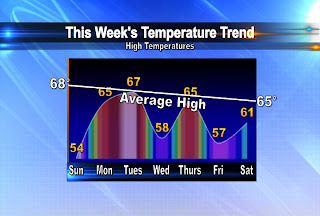
It's time again to take a look at this week's high temperature trend over the next 7 days in the Quad Cities! After a chilly weekend more seasonable, warmer air does return to the QCA on Monday and Tuesday. But, the warmer weather stick around for very long. That's because a cold front will knock our temperatures back below average into the upper 50s by Wednesday. They'll rebound for a day before another disturbance sends them back in the other direction! We'll keep you posted.
Friday, October 5, 2012
Colder and Colder and Colder...
It just keeps getting colder in the Quad Cities! The big drop started yesterday and it continues as we kick off our weekend today. Temps have been in the 40s for most of the afternoon, when the normal high is 69°! Tonight, with some clearing, we'll see lows in the upper 20s and lower 30s and that's prompted the NWS to issue a FREEZE WARNING for all of the areas shaded in blue. The only reason a few counties to the North are not included is because those areas have already seen their growing season end, when the temp dropped into the upper 20s back in September!
What a difference a day makes.....
This morning most neighborhoods started out 15 to even 25 degrees cooler.
Temperatures will stay well below average over the weekend as high temps only climb into the low to mid 50s! Stay warm and have a great weekend.
Thursday, October 4, 2012
Cold Front Moves Through...
The much advertised cold front has now pushed through the Quad Cities! Our temps earlier today were near 70° and now we're back into the 50s, with lows dipping into the upper 30s later tonight. The next few days will be much cooler than normal, with highs only in the 50s. As for the rain, we've seen scattered showers so far and from here on out most of the wet weather will be south of the Quad Cities!
Tuesday, October 2, 2012
Big Weather Changes Coming...
Soak up the sunshine and near 80° weather on Wednesday, we have big changes set to arrive later this week! A cold front passes through the region on Thursday, bringing a chance for a few showers/t-showers. While the chance for rain stands at about 50% the chance for much cooler weather stands at 100%. Count on a big October chill this weekend...as for tonight's temps? They're fine and you'll see them on Ten at 10 on CBS4!
Blizzards to be named by TWC?
USA Today announced today that The Weather Channel will now be naming blizzards and intense winter storms. Hurricanes and tropical storms have been named since the late 1800's, and now blizzards will get the same recognition.
The Weather Channel says some major storms in the past have already received a few nicknames, such as snowmaggeddon, and it would be a bit easier to distinguish those storms if they had names. They already have a list of 26 names for potential winter storms, starting with Athena, Brutus, and Caesar. The names follow a Greek/Roman theme and there are no repeats of hurricane/tropical storm names.
The names will be issued to winter storms that will have a big impact on large areas of population and the storms will only be named 3 days prior to the expected impact. However The Weather Channel has not listed or described any criteria on how they will determine if it will be a major storm. The goal is to raise public awareness of the intensity of these big winter storms.
The Weather Channel says some major storms in the past have already received a few nicknames, such as snowmaggeddon, and it would be a bit easier to distinguish those storms if they had names. They already have a list of 26 names for potential winter storms, starting with Athena, Brutus, and Caesar. The names follow a Greek/Roman theme and there are no repeats of hurricane/tropical storm names.
The names will be issued to winter storms that will have a big impact on large areas of population and the storms will only be named 3 days prior to the expected impact. However The Weather Channel has not listed or described any criteria on how they will determine if it will be a major storm. The goal is to raise public awareness of the intensity of these big winter storms.
Monday, October 1, 2012
September Climate Numbers
September has come and gone, and it turned out to be another dry month! We started off with some rainy days at the beginning of the month but overall we only ended up with 2.19" of rain which is almost an inch below normal.
As far as the temperatures went - we actually ended up below normal for the first time in several months! The average temperature was 62.7° which is almost 3 degrees below normal!
For more climate info check out this page from our local office of the NWS! Quad Cities NWS Climate stats
As far as the temperatures went - we actually ended up below normal for the first time in several months! The average temperature was 62.7° which is almost 3 degrees below normal!
For more climate info check out this page from our local office of the NWS! Quad Cities NWS Climate stats
Subscribe to:
Posts (Atom)