Saturday, July 31, 2010

Weekend Update


Here's a quick check of the forecast for the rest of the weekend, for more details check out CBS4 News at 6 (Saturday) or Ten at 10 on CBS4! Overall things look pretty good for Sunday, with a chance for rain arriving late Monday night or Tuesday.

Friday, July 30, 2010

Update on the Tropics


While we get ready for August here in the Quad Cities places along the gulf coast are getting ready for hurricane season to really get going! Officially hurricane season runs from June 1 through November 30...but there's a definite "busy time" from mid August through mid October. While September is typically the most active month in the Atlantic basin things generally start picking up in August! With that being said here's a graphic from the National Hurricane Center showing a couple areas they're watching for potential development! Here's the link to their site...

http://www.nhc.noaa.gov/

Wednesday, July 28, 2010

Sctd. T-Storms This Afternoon/Evening


We've got a few thunderstorms popping up around the QCA this afternoon. Storms are developing in a hot and humid air mass just ahead of a cold front that is moving through the area today. Once the front passes this afternoon/evening the storms will end, and humidity will be noticeably lower Thursday! In the meantime, as storms continue south of the QC a few could provide small hail and gusty winds, so there's a Svr. T-Storm Watch in effect 'til 7pm south of the QC.

Tuesday, July 27, 2010

Rock Island River Update...


While the Mississippi River has been slowly RISING today, the forecasted crest in the QC has been slowly FALLING! Right now the river looks to be cresting and should slowly fall through the end of the week.

Check out CBS4 News at 5 and Ten at 10 on CBS4 for continuing Team Coverage of the July floods.

Monday, July 26, 2010

Flooding Pics


Thanks to Kierstin Dimmick for the first 3 pics (Savanna and Mt. Carroll, IL) and to Aaron Adrian for the last 2 pictures (Galena, IL.) Check out CBS4 News at 5 and Ten at 10 on CBS4 for team coverage on the major flooding taking place around the Quad Cities!

Saturday, July 24, 2010

Big River Rising


Spared from the Worst...

In the QC we've lucked out considerably over the last few days...some cities nearby are experiencing MAJOR flooding! Milwaukee and Southern Wisconsin were hard hit a couple nights ago, and Friday night into Saturday morning Chicago and most of Northern Illinois have been hit very hard with rain. Portions of Illinois have received up to 10 INCHES of rain in the last 24 hours, and some places have picked up about 13 to 14 inches of rain in the last 48 hours! In some cases that's more rain than usually falls in a span of 4 months!

Even though river levels had been fairly low a few days ago the water is now rising extremely quickly on all rivers around the QC and for areas to the North. Even the Mississippi river will experience MAJOR flooding over the next few days in the Quad Cities. LeClaire Park, which has been hosting Bix events over the last few days, will more than likely be flooded this week according to the NWS in the Quad Cities. Check out this link to check area river forecasts:

http://water.weather.gov/ahps2/index.php?wfo=dvn

Here's the forecast image for what will happen on the Mississippi River in Rock Island in the days to come:


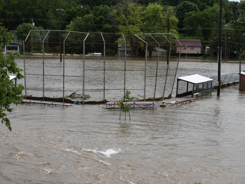
Also alarming, here are some of the storm reports from the NWS in Davenport this morning:

1200 PM FLOOD 2 W MILLEDGEVILLE 41.96N 89.81W
07/24/2010 CARROLL IL TRAINED SPOTTER

ROCK CREEK IS FLOWING OVER A ROADWAY WEST OF TOWN.

0615 AM FLASH FLOOD GALENA 42.42N 90.43W
07/24/2010 JO DAVIESS IL TRAINED SPOTTER

FIRE WATER RESCUES FOR CARS HAVE BEEN TAKING PLACE NEAR
GALENA...STOCKTON..AND SCALES MOUND OVER THE PAST HOUR OR
TWO. SPOTTER IS PART OF ELIZABETH FIRE DEPT. ALSO REPORTS
BRIDGE WASHED OUT AT LITTLE RUSH CREEK AND BETHEL ROAD.

0825 AM HEAVY RAIN SSE SHANNON 42.15N 89.74W
07/24/2010 M4.40 INCH CARROLL IL TRAINED SPOTTER

24 HOUR TOTAL. 48 HOUR RAINFALL TOTAL IS 10.45 INCHES. IT
IS STILL RAINING.

0700 AM HEAVY RAIN MOUNT CARROLL 42.10N 89.98W
07/24/2010 E7.70 INCH CARROLL IL TRAINED SPOTTER

48 HOUR RAINFALL TOTAL.

Stay tuned to CBS4 News and cbs4qc.com as this situation continues to develop over the next few days!

Friday, July 23, 2010

Heavy Rain Early Friday


From Thursday evening through Friday morning portions of Southern Wisconsin got pounded with heavy rain...Milwaukee has had all kinds of problems with flooded streets, basements, the airport there was even shut down Friday morning.

Early Friday morning the axis of heavy rain shifted a little closer to the Quad Cities and ended up flooding large portions of Jo Daviess, Carroll and Whiteside counties. Here's a map from the NWS in the Quad Cities showing rainfall totals ending at 7 am on Friday. Unfortunately there's another chance for showers/storms/heavy rain Friday into Saturday!

Thursday, July 22, 2010

Severe Weather Outbreak in Wisconsin


It's been quite a severe weather event across Southern Wisconsin tonight. About 10 tornadoes have been reported from Madison to Milwaukee. Fortunately for us in the QC the worst of the weather has stayed away, but remember a HEAT ADVISORY is in effect for Friday!

Wednesday, July 21, 2010

Weather in Your Backyard!


We're heading to West Davenport for this week's 'Weather in Your Backyard!' Check out all the fun today at 5pm with a recap later tonight on Ten at 10. If you want to host a party with a lot of free food check out the details on cbs4qc.com

Monday, July 19, 2010

Severe Weather Update


While the chance for some scattered showers/storms is still with us in the QC tonight, the main severe weather event will be unfolding SOUTH of the QC tonight. The far southern part of the viewing area will be affected though by strong thunderstorms, strong winds and very heavy rain. There's a host of warnings/watches in effect south of the QC including:


Svr. T-Storm Warnings
Svr. T-Storm Watches
Flash Flood Warnings
Flash Flood Watches

Severe Weather Chance...


We do have a 'Slight Risk' for severe weather this evening in the QC, but the longer we stay cloudy with scattered showers and weak t-showers across the area the chance for severe weather will be going down. As of 2:30 we're only looking at sctd. showers with not strong storms popping up just yet...stay tuned!

Sunday, July 18, 2010

Hometown Forecast


Sunday Nights' Hometown Forecast (Every Sunday on Ten at 10 on CBS4)
If you want your Hometown on our newscast-- send us a picture of your town to weather@cbs4qc.com or tmcinerney@cbs4qc.com and we will put it up on our blog and our 10 o'clock newscast.
CBS4 Meteorologist Ted McInerney

Thursday, July 15, 2010

Not Quite So Bad...

While it's another warm day Thursday, things aren't nearly as bad as they were about 24 hours ago. Temperatures are down, humidity is down and that means the heat index are down significantly. Notice some of the different shading Southeast of the QC...the hottest and most humid air has been pushed that way, for now!

Wednesday, July 14, 2010

Heat Index Update

Heat Index readings are soaring this afternoon as the HEAT ADVISORY remains in effect until 9pm for most of the area. Showers and t-storms will offer some relief later this evening. We do have a slight risk for severe storms with damaging winds, and there's a very good chance for a widespread severe weather outbreak through portions of Minnesota and Wisconsin, for more on that check out the NWS SPC (Storm Prediction Center) website.

http://www.spc.noaa.gov/

Tuesday, July 13, 2010

HOT HOT HOT!


Get ready for some big-time summer heat and humidity Wednesday! Temperatures will reach the lower to mid 90s and with dew points around 75 it will feel like it's about 105 for most of the afternoon. This is dangerous heat and everybody needs to be careful if you're going to be outside for any period of time Wednesday...check out this link from the NWS for tips on how to "beat the heat."


Monday, July 12, 2010

New Park in Rock Island


Have you checked out SCHWIEBERT RIVERFRONT PARK in Rock Island yet? It's a great place, with a great view of the river and Davenport. Each time I've been there the crowd has been pretty decent and the kids have been loving the fountains. I was there this Sunday and took this picture (gotta love the cell phone cameras!) just before the sunset around 8:30pm.

More July Rain


The heavy rain from this evening is now moving off to the East but it's left behind more wet yards and streets. Here's a look at some of the rain totals so far from Monday (through 9pm) and in the Quad Cities this pushes our total for July over 4 inches already!

Sunday, July 11, 2010

Friday, July 9, 2010

JDC - Round 3 Forecast


The JDC is off to a great start, weatherwise and golfwise! Things look nice for Saturday also, with more sunshine coming up at Deere Run...

Wednesday, July 7, 2010

JDC - Round 1 Forecast


One of our biggest events of the year is just about to officially kick off in the QC...It's JOHN DEERE CLASSIC time! While Thursday could be wet things do look better for Friday and Saturday. For those forecasts stay tuned to CBS4 News and cbs4qc.com! In the meantime here's what we're looking at for Thursday...


Monday, July 5, 2010


Here's a check of the forecast for the upcoming John Deere Classic! It's hard to believe our big PGA tournament is just about here again...and while the practice rounds and Pro-Am might have to dodge a few showers/thundershowers things are looking better for the end of the week and the weekend. Make sure you watch CBS4 News all week long as we bring you non-stop action from Deere Run!

Thursday, July 1, 2010

A Dry End to a Wet Month!

June 2010 is in the books! And it turned out to be one of the wettest Junes on record in the Quad Cities! Officially we ended up with 8.67" of rain, that's good for 7th place on the list of wettest Junes on record! The temperature average came in at 73.9°, which is also above average. The normal temp average is around 71.2°.

To check out more stats head on over the the NWS Quad Cities homepage located here:

http://www.crh.noaa.gov/dvn/

And to check out some of the climate records/normals for the QC go to this page:

http://www.weather.gov/climate/index.php?wfo=dvn