Tuesday, July 30, 2013

Wet and Cool in the Quad Cities

What a day!  When you think of July today's weather probably doesn't come right to mind!  Thermometers only climbed to 68°, which is almost 20 degrees below normal!  It wasn't just the temps that set today's weather apart from a typical July day in the Quad Cities...it was an exceptionally cloudy day too!  We managed some rain, and then the clouds hung around all day long!  Here are some of the rain totals from Tuesday -


It is still July (for one more day) and things will warm back up to around 80 by Wednesday afternoon!


July Chill

It's summer in North America, but if you spent any time outdoors over the past few days, you probably noticed a chill in the air.

High temperatures this past Saturday only made it up to 67° in the Quad Cities.  This past weekend was the coolest weekend since the last one in May when highs both days only made it into the upper-50s.

This is a Sky Cam shot of the Mississippi River from last Friday evening around sunset.


The average high this time of the year is 85°.  With the clouds and rain today, highs will only reach around 73°.  We typically see highs in that territory in mid-May and late September! 

So, if you want more summer heat, just think it's mid-May and it'll get warmer in the weeks ahead.

And, if you love fall weather, just imagine it's late September and more autumn chill will follow.

Enjoy your week, regardless of the weather!

CBS4 Meteorologist Anthony Peoples

Monday, July 29, 2013

'Flossie' Wreaking Havok on Hawaii

It's been relatively quiet as of late in the Quad Cities.  The biggest weather story has been the well below normal temperatures for this time of year.  We do have a chance for scattered showers on Tuesday, and a couple more chances of rain later into the week.  The story is much different in Hawaii.

Tropical Storm Flossie has her eye on our nation's 50th state.  The picture above looks like a big red blob, but it's a map of Hawaii depicting the tropical storm warnings.

While the storm has been weakening over the last couple of days, it will still pack a punch.  As the storm moves in, waves of 10 to 15 feet can be expected, as well as some torrential down pours.  Flash flooding is a threat to the islands.  Wind speeds will be between 35 and 45mph, with gusts above 50mph. 

For more information on what actions are being taken, click on the CBS News story on Tropical Storm Flossie's impact.

Sunday, July 28, 2013

Gradual Warm Up This Week

It was an unseasonable cool weekend here in the Quad Cities.  The calendar said late July, but Mother Nature decided to give us a preview of early October!  The high temperature on Saturday was a chilly 67° at the airport in Moline.  That was just two degrees shy of the record low maximum temperature for that date, which was 65° (set back in 1981).  And speaking of records, the temperature was in the upper 50s at race time for the 39th annual Bix 7 road race, which is the coldest ever!  The previous record was set back in 2004 with 61°!

Here's a look at Sunday's stats, along with a fantastic sunset!

We were just one degree shy of our record low in the Quad Cities!  Burlington, IA had a record low of 52° Sunday morning, as did Dubuque, IA with 50°.

The forecast for this week does show a gradual increase in the temperatures through much of the week, before seeing yet another cool down by next weekend.

We also have a few chances of rain in the forecast, which is good news as we are sitting just a little over 2 inches below average for this month.  Overall, we are almost 8.5 inches above average for the year!

Friday, July 26, 2013

A Cool Bix 7 Weekend

It's a busy weekend in the Quad Cities -- Bix 7 weekend, of course!  This is the 39th year for the 7 mile road race through the streets and hills of Davenport.  Normally the end of July brings temperatures in the middle 80s along with humidity.  That's definitely not the case this year.  Take a gander at this forecast:

The average high for July 27th is 85° and the average low is 65°.  As you can see from the graphic, we are going to be anything but average.  In fact, we will be within 3° of a record low temperature.  The record minimum high temperature for tomorrow is 65°.

Since we're on the topic of temperatures, the highest temperature at race time (8AM) for the Bix 7 happened in 1997 with a temperature of 83°, and adding humidity made it very uncomfortable for runners.  The coolest temperature at race time occurred recently in 2004 with a temperature of 61°, so that may very well be in jeopardy come Saturday morning.

If you're running the race, good luck!  Expect the below average temperatures to remain through the middle part of next week.

Thursday, July 25, 2013

Where do the "normals" come from?

At CBS4, we show you the daily "Almanac" that shows the temperatures observed, the normal temperatures, and the record temperatures.


Many people may wonder how the "Normal" temperature is calculated.  It's actually rather simple.  Take today (July 25th) for example.  Our normal high temperature is 86° and our normal low temperature is 65°.  These are 30 year averages.  So, all the high temperatures and low temperatures on July 25th from the years 1981 through 2010 were added up and divided by 30 to get the average.  Beginning in 2021, we will be basing our average temperatures from the years 1991 through 2020.

Lately you've probably heard us say temperatures are below average.  That is going to continue for at least the next week or so as temperatures are going to be in the mid 70s to lower 80s.  Looking ahead 8 to 14 days, temperatures should eventually reach back to normal territory.


Wednesday, July 24, 2013

Autumn Preview in July

The Quad Cities woke up this morning to an official low of 55°, which was just a degree above the record low for the date.

High temperatures through this weekend will be in the upper-70s to low-80s with overnight lows generally in the 50s.

These temperatures are more common in early-to-mid-September.

We start the month of September with highs around 81° and lows near 60°.  However, by the end of the month, temperatures drop off quickly to highs and lows around 71° and 48°, respectively.

Don't get used to the autumn preview this week because high temperatures by the end of July will return closer to average in the mid-80s.

CBS4 Meteorologist Anthony Peoples


Sunday, July 21, 2013

Last Full Week of July?

Yesterday I posted the Climate Prediction Center's forecast for the next 6 to 10 days, and the trends showed cooler than normal temperatures for the region.  I continue to see that trend in the forecast.  In fact, I have a temperature in the upper 70s in the 7 Day Forecast!

We'll see a pretty warm day Monday with temperatures reaching the mid to upper 80s.  It will also be humid, with dew point temperatures in the upper 60s to around 70°.

As mentioned, a change is on the way.  Another cold front has it's eyes on the Quad Cities, and will roll on through the area late Monday afternoon and evening, bringing with it the chance for a few more scattered showers & thunderstorms.  This won't be a widespread event, and severe weather does not look like a threat.

Tuesday, our temperatures drop to the lower 80s and the humidity drops as well.  Here's the 7-Day outlook.  Look at BIX WEEKEND!  Big contrast to last year, that's for sure!


Of course, the Bix is still about 6 days out, and newer data coming in does show the rain could be out in time for the road race.  The CBS4 weather team will keep you updated throughout the week!

Saturday, July 20, 2013

What's Ahead?

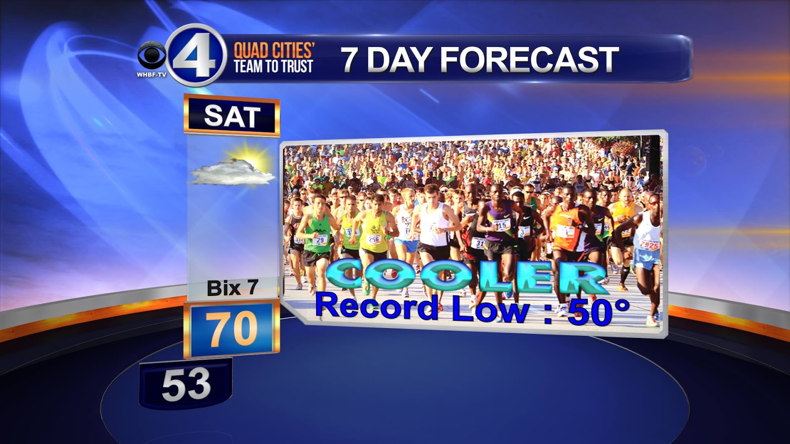
Whew, it was a hot one out there this past week!  We had temperatures in the low to mid 90s all week long, and what made it worse was the humidity!  Dew point temperatures ranged anywhere from 70° to 75°, making it feel like it was anywhere from 100° to 105°.

Fortunately the cold front that rolled through the QCA Friday dropped those humidity levels.  Temperatures were still pretty warm Saturday, with the high at the airport in Moline topping 89°.  With a dew point in the low 60s, it didn't feel so bad!

It looks like cooler, less summer-like weather is on the way!  Here is a couple images from the Climate Prediction Center on precipitation and temperatures trends for the next 6 to 10 days.
Parts of the area have a 50% to 60% chances of seeing below normal tempreatures.  Looking over the latest data, I agree with this trend.  Temperatures won't be cold by any means, but will be below average, nonetheless.
The precipitation outlook has nothing too out of the ordinary.  Areas southwest of the Quad Cities show an above normal temperature precipitation trend, and areas northeast have a below average trend.

The key word in this: trend!  Meteorologists get new, long range data in every six hours or so, and many times it's hard for models to pick up on what is exactly going to happen more than 3-5 days out.

Of course, you can check out the forecast anytime by clicking HERE!
Meteorologist Kyle Kiel

Friday, July 19, 2013

Driest Month This Year, So Far

A few showers are possible Friday afternoon along a cold front that will bring cooler temperatures for the weekend.  We could be seeing more showers and thunderstorms Sunday into early next week. 

The Mississippi and Illinois Valleys desperately need some rain.  Prior to today, it's only rained two times this July in the Quad Cities (July 8 and 9) for a total of 0.73". 

This is, by far, the driest month in 2013.


In a typical July, we pick up 4.29" of rain in the Quad Cities.

CBS4 Meteorologist Anthony Peoples

Wednesday, July 17, 2013

"Heat Advisory" Through Friday Evening

3PM UPDATE: As of 3pm the heat index has soared to 102° in the Quad cities!  The actual temperature is 94°, the hottest day we've had since last August 7th when it was 97°!


Previous Post:

Much of the Mississippi and Illinois Valleys are under a "Heat Advisory" through Friday evening as temperatures climb into the low-to-mid-90s.  Once you factor that heat with high humidity, it's going to feel like 100°-105° Wednesday, Thursday, and Friday afternoons.


While a cold front passing through the area might bring some much-needed shower activity Friday night and cooler temperatures (82°-85°) for the weekend, more heat and humidity will build next week.

NOAA's Climate Prediction Center is forecasting above average temperatures through the end of July.


So far, this July, we've only picked up 0.73" of rain, which is 1.80" below average.  It could be worse.  At this point in July last year, we had only picked up 0.21" of rain in the Quad Cities.

CBS4 Meteorologist Anthony Peoples

Tuesday, July 16, 2013

Heating Up but Still No Comparison to Last July

Things have warmed up significantly in the Quad Cities over the last couple days...and there's more warm weather coming up this week!  However, even with highs in the 90s, this is nothing compared to the first half of July 2012!  Last year we had already spiked to 104° by this time in July, that's 104° for the temperature, not the heat index!  Also, while things have dried up this month last July was bone dry!  We had less than a quarter of an inch of rain through the first 16 days of the month...

Finally, check out the average high for the first 16 days:  Last July the AVERAGE high was a whopping 93.4°, this year the average high so far has been a mere 84.9°!


Monday, July 15, 2013

Cars Heat Up Quickly

With temperatures approaching 90° for much of this week, I want to remind you not to leave your pets or your children left unattended in the car while you run a quick errand.

In just 10 minutes, the temperature inside the car can rise to 20 degrees higher than the outside air. In 20-30 minutes, it is about 30-35 degrees hotter inside the car and in an hour, it can be 40-50 degrees hotter in the car.

That means on a 70-degree day, the inside of the car can heat up to 120 degrees.

And, cracking the windows does little to keep the inside of the car safe from the heat.

About 40 children and between one thousand and two thousand dogs die inside cars each year in the United States from overheating accidents when parents run inside stores for just a few things.

Be safe out there today and this summer!

CBS4 Meteorologist Anthony Peoples

Saturday, July 13, 2013

A Touch Humid for the Final Round of the JDC

Well you couldn't have asked for better weather during the John Deere Classic!  Temperatures were in the 70s and 80s during play, and the humidity has been relatively low for this time of year, a complete turn around from last year's tournament.

Here's a look at the forecast for Sunday's final round.  Temperatures will be in the mid to upper 80s, and with dew points creeping up, it's going to be a little more humid than what golfers, volunteers and spectators have seen throughout the tournament.

Last year the tournament ended on July 15th, with a high temperature of 94°!

The humidity will continue as we head into the next work week, with dew point temperatures rising to near 70° with near daily chances for showers & thunderstorms.  Check out the 7-day forecast by clicking on this link.

If you're headed out to watch the final round, enjoy!  Don't forget the sunscreen.  And if you aren't headed out and still want to watch the tournament, it will be broadcast right here on CBS4!

Thursday, July 11, 2013

Quad Cities Anniversary Coming Up


This Sunday marks the 77th anniversary of the HOTTEST DAY EVER IN THE QUAD CITIES!  On July 14, 1936 the Quad Cities, and most of the country, baked under an unprecedented and since unmatched dome of heat!  The temperature in the Quad Cities soared to 111°!  This wasn't a one-day affair either...the summer of 1936 is the worst on record for a lot of cities throughout the Midwest.  This record is one of more than a dozen from July, 1936 that still stands! 

To this day these are current record highs set during the month...

July  Temp
5       105
6       105
7       105
8       104
9       102
10     105
11     107
12     108
13     107
14     111
15     106
17     103
26     106


I guess it could have been worst last summer when we soared up into the 100s 5 times during the month of July!


Recent Second Round Play Rains

The first round of the John Deere Classic is underway and the weather couldn't be nicer.  We started Thursday with a low temperature of 59° in the Quad Cities, which was 17° cooler than Wednesday morning's low.

Dry weather is expected today through Saturday.


Looking back at the second round play over the past five years, we experienced rain in three of the five years.  While it was just a little rain last year (0.01") and in 2008 (0.03"), it was torrential rains that we dealt with in 2009.

2.46" of rain fell in thunderstorms that halted play in the afternoon.  While that was a major inconvenience for players, spectators, and organizers, it wasn't a record rainfall for that date. 

Back on July 10, 1971, 5.08" of rain fell on that date to establish the record rainfall.

CBS4 Meteorologist Anthony Peoples


Wednesday, July 10, 2013

John Deere Classic First Round Highs

It's Pro-Am day at the 2013 John Deere Classic at TPC at Deere Run in Silvis, Illinois.  After a very humid start to the day, humidity levels are dropping thanks to a nice refreshing northerly breeze.  High temperatures Wednesday will be around 84°.

Professional play gets underway Thursday with the first round of the tournament.  It's going to be a comfortable day for players and spectators with highs around 82°.  Here's a look back through 2008 of the first round high temperatures.


The only measurable rain on the first round day in that same time period was back in 2010 when only 0.01" fell.

CBS4 Meteorologist Anthony Peoples

Monday, July 8, 2013

Severe T'Storms Possible, Another Humid Day Likely!

Here's a quick glance at part of our 7-day forecast...notice the high temperature Tuesday and the chance for strong/svr. t-storms also!  The NWS SPC has all of the CBS4 viewing area under a slight risk for severe storms.  Right now the biggest threats look to be damaging winds and hail.  This will all depend on if we can clear out the debris clouds from Monday night's storms, which would allow the atmosphere to heat up substantially! 

Slight Risk in Yellow

It will definitely be warm and muggy, with heat index values way up in the 90s!  However, unlike last July, the heat will not stick around all month - it will be much cooler for Rd 1 of the John Deere Classic on Thursday! 
Heat Index Model Forecast

Dry, But No Drought Like in Summer 2012

Thunderstorms early Monday morning brought a much needed 0.55" of rain, officially, to the Quad Cities.  There were reports of 1-3" of rain in Dubuque County, Iowa, from the same line of storms.

Before this morning's rain, we had gone eight days without any measurable rain in the metro area and the ground was starting to dry out.  Lawns that weren't being watered were becoming a little stressed.

As of last week, only about 1.7% of the Midwest is "abnormally dry" compared to 71.1% of the same area one year ago.

A "moderate" drought is currently taking place over northern Minnesota, which only accounts for about 0.7% of the Midwest.  This time last year, 45.8% of the Midwest was experiencing "moderate" drought conditions.


And, while no part of the Midwest is experiencing "severe" or "extreme" drought conditions this year, one year ago, those numbers were at 15.3% for "severe" drought and 5.3% for "extreme" drought.

More scattered showers and storms are likely later tonight and Tuesday before cooler and drier air takes over our weather.

CBS4 Meteorologist Anthony Peoples

Saturday, July 6, 2013

The Difference of One Year

I've been thinking about how much different this summer has been compared to last summer.  I am sure many of you remember we were dealing with a drought and very hot & humid weather conditions.

This year, we've been the complete opposite.  We've had below average temperatures, and way above average precipitation, with several rounds of flooding on area rivers.

I decided to do small comparison of June 1st through July 6th of last year, and compared it to the conditions seen the same period this year.

From June 1st through July 6th last year, we saw a total of 1.52" of rainfall, and 14 days of temperatures at or above 90°!   Compare that to this year.  We have seen a whopping 6.14" of rainfall, with only TWO DAYS of temperatures at or above 90°.

Here is a look at the Climate Prediction Center's 6 to 10 day outlook for precipitation & temperatures.  Nothing too extreme on one end or the other, which is some great news as we head into John Deere Classic week!

 ------------------------------------------------------------------------------------------
Meteorologist Kyle Kiel

Thursday, July 4, 2013

John Deere Classic Weather

A lot of us are used to some pretty hot weather around the John Deere Classic.  While every year hasn't been scorching for the tournament in Silvis it does tend to be warm and muggy, after all (for the last several years) the tournament is in July!  Considering how hot July of 2012 was we actually lucked out with the some of the "coolest" weather of the month centered around the JDC.  Here are the highs from last year's tournment, won by Zach Johnson!

Rd 1- 92
Rd 2- 84
Rd 3- 90
Rd 4- 96

This year's tournament looks even cooler!  Here's a 6-10 day forecast from the Climate Prediction Center showing temps in the Quad cities likely to be a little below average from July 10-14th!

.
And another look at forecated temps shows after peaking this weekend and early next week we should see a slight decline in temps just in time for the tournament! 

.

We'll keep you posted as the tournament gets closer and remember, with our 10-day forecast you can NOW SEE the JDC classic on CBS4 News!  After all, the start of the tourney is only a week away! 

Wednesday, July 3, 2013

Past Fourth of July Weather

"Red, White & Boom" will be exploding over the Mississippi River in the Quad Cities tonight.  I hope you all have a great Fourth of July planned. 

It'll be a little warmer tomorrow with highs in the low-to-mid-80s and we'll have to contend with some scattered showers and thunderstorms.


On the Fourth of July in the Quad Cities, the average high is 86° and the average low is 65°.

Since our record keeping started back in the early-1870s, only two Independence Day celebrations saw temperatures of 100° or higher.  In 1901, we reached 100° and in 1911, it was 102°!  The coolest high temperature on the Fourth was 67° in 1967.

49% of the Fourths here have been in the 80s for highs, while 26% have been in the 90s!

The heaviest rainfall on the Fourth was in 2007 when 3.56" fell in the early morning hours that day.  51% of the Fourths have featured not a drop of rain and only 5% have picked up an inch or more.

Last year, it was 96° on Independence Day in the Quad Cities.

Have a safe and enjoyable holiday!

CBS4 Meteorologist Anthony Peoples

Monday, July 1, 2013

Cool Locally, But Record Desert Heat

The first six months of 2013 are behind us and July is off to a cooler than average start in the Quad Cities.  The average high this time of the year, in the metro area, is around 86°.  High temperatures for the first three days of the month are only expected to reach the 70s to near 80°.

While we're enjoying a break from the summer heat, it's a much different story in the Desert Southwest where parts of California, Arizona, and Nevada are experiencing record heat.


Some of the high temperatures today and tomorrow will be approaching all-time record highs.


Yesterday, it hit 117° in Las Vegas, Nevada, which tied the all-time record high that was reached on two other occasions in 1942 and 2005.

No real relief in the intense heat is expected through the weekend!

CBS4 Meteorologist Anthony Peoples