Friday, April 11, 2014

Our New Website - ourquadcities.com/weather

Have you checked out the new ourquadcities.com?  It's our new website and it will now serve as the CBS4 weather blog site as well!  We hope you check it out, you'll find tons of useful info on the weather page.  Overall, the site acts as a community portal, not just a television station's website.  That means you'll find all kinds of helpful info about the Quad Cities area, do us (and yourself) a favor and check it out!


And when you're looking for blog posts that you've been finding ou this blog just head to the Weather page and click on the Weather Blog tab!

As always, thanks for looking us up!

www.ourquadcities.com.weather

Sunday, March 30, 2014

Multiple Chances for Rain This Week

We experienced a beautiful spring weekend in the Quad Cities.  Highs on Saturday were in the lower to middle 50s with plenty of sunshine.  After a chilly start in the upper 20s on Sunday, plenty of sunshine and gusty southerly winds aided in warming temperatures into the lower to middle 60s.  Typically this time of year we should be in the middle 50s.

An area of low pressure will be strengthening to our west and head northeast throughout the day on Friday.  Fortunately, we will be on the warm side of the storm with another day of temperatures in the 60s and gusty southerly winds from 15 to 25mph+.  The low pressure will have a cold front that will plow through the area later Monday evening, and that's when we have the best shot of seeing scattered showers/isolated t'storms.  Out ahead of the front during the day, there is also the threat for a few scattered showers.  Rain fall amounts will be a tenth of an inch or less as moisture is limited.
Once the front rolls through, brisk northwest winds will usher in colder temperature for Tuesday.  The cool temperatures will continue through the rest of the week, with highs averaging in the upper 40s.  We get a break from the rain on Tuesday before more chances of rain come in Wednesday, Thursday and Friday.  Rain totals could be approaching 1 inch by the end of the week.

Saturday, March 29, 2014

Warm End to the Weekend

It was a fine start to the weekend with partly to mostly sunny skies (after an overcast Saturday morning) and temperatures in the upper 40s to low 50s.  Average highs this time of year are in the middle 50s, so not too bad for early spring standards.

If you liked the temperatures during the first half of the weekend, you'll love the second half.  After a chilly start near 30° Sunday, we'll see a warmup to the 60s!
High pressure will be off to the east which will bring our winds in warmer winds from the south between 15 and 20 mph, gusting 25 to 30 mph at times.  Humidity will be low so brush fires are a possibility on Sunday.

Looking ahead, Monday temperatures will be in the middle to upper 60s with a chance of showers and even a few thunderstorms ahead of a cold front that will sweep through Monday evening.  This will usher in cooler temperatures for the rest of the week, as well as a few other rain chances.  Unfortunately, I don't see a big warmup in the next week, after Monday.

Tuesday, March 25, 2014

Cold Today, But A Warming Trend Follows

Spring is officially here, but it sure doesn't look or feel like it across the Mississippi Valley.

The 0.9" of snow that fell in Moline Monday night brings our winter total to 65.1".  That is more than double the snow we see in an average winter!  We're still 4.6" shy of the snowiest winter on record.

While it will be very cold today and tonight with temperatures running about twenty degrees below average for late March, a warming trend in on the way.

We'll see highs well into the 40s and 50s Wednesday through Saturday and highs in the 60s Sunday and Monday!

This will be the first time we've seen back-to-back highs in the 60s since back in mid-October, more than five months ago!

But, it doesn't appear that it's going to last.


The Climate Prediction Center is forecasting below average temperatures for the month of April for Illinois and Iowa.

CBS4 Meteorologist Anthony Peoples

Sunday, March 23, 2014

Where's Spring?

Spring officially began at 11:57am last Thursday, March 20th.  The high temperature that day was 52°, and the first full day of the season featured highs around 62°!  Temperatures Saturday were in the 40s and on Sunday, they were in the 30s!
Sunday's temperature of 34° was 18° below the average high of 52°.  The trend for much of the next week is below average.  By Thursday we creep close to 50, and by the end of next weekend we could be approaching the 60° mark once again.

But before that, a couple bumps.  We have a clipper-type system that is going to track southwest of the Quad Cities, bringing us a shot at some light snow.  The "heavier" snow is going to stay in southwestern hometowns, where an inch to perhaps two inches will fall.  Elsewhere, a half inch to an inch looks like a good bet.  This system isn't as organized as it looked a few days ago, and doesn't have much moisture to work with.


Behind the system?  More cold air.  Lows Monday night into Tuesday will be in the teens and lower 20s, with highs struggling to reach 30° for many areas by Tuesday.

Tuesday, March 18, 2014

More Chill To Come

While we may see some rain tonight and some light snow Wednesday, highs today, Thursday, and Friday are expected to reach the 50s in the Quad Cities!

This is good news considering that our temperatures have been below average since October 2013.

However, after Friday, we're back into the chilly air again. 

The average highs this time of the year are now above 50° in the metro area and check out these predicted temperatures through the end of March from the Climate Prediction Center.


Brrrrrrrrrrrrrrrrrrr!

CBS4 Meteorologist Anthony Peoples

Friday, March 14, 2014

A Mild Saturday, Then Snow At Night!

It's hard to believe that with high temperatures Friday in the 50s and highs Saturday near 50° that snow is, once again, in the forecast Saturday night and Sunday morning.

Early indications point to an inch with slightly higher amounts to the north.


But, it should come as no surprise when you think of how snowy its been this winter (62.4" officially in the Quad Cities).

And, it's even more fitting that the snow chances arrive on the weekend.

This winter, we've only had one weekend that a snowflake didn't fall (January 10-12, 2014) and three others featured only a trace of snow.

The Top Five snowiest weekends this winter:

7.8"  January 3-5, 2014

5.5"  December 20-22, 2013

3.9"  January 31-February 2, 2014

3.7"  February 28-March 2, 2014

3.3"  December 13-15, 2013

CBS4 Meteorologist Anthony Peoples

Wednesday, March 12, 2014

Where is the Snow?

The Quad Cities and hometowns to the northwest got cheated out of a decent accumulating snow Tuesday night and Wednesday morning.

It took longer for the rain to transition over to snow and once it started snowing, the precipitation shield was already heading out of the metro area.

Officially, 0.2" of snow fell at the airport in Moline.  That brings us up to 62.4" for the winter of 2013-2014.


Look at how close the cut-off line was at 3:45 a.m. Wednesday.

Snowfall amounts to the south and east of the Quad Cities were in the 1-3" range.  Chicagoland snow totals are around 2-7".

Flurries are possible today and tonight, but no accumulation is expected.

Highs in the 40s return tomorrow and we'll be in the 50s Friday!

CBS4 Meteorologist Anthony Peoples

Tuesday, March 11, 2014

Another Winter Storm On The Way

A late winter storm is on the way tonight and early Wednesday and threatens eastern Iowa and the northern half of Illinois with snow.

After an official high of 58° Monday, highs today should make it into the upper-40s to help melt away more of the old snow.

Light rain developing this evening will quickly change over to light to moderate snow tonight and early Wednesday.


A "Winter Weather Advisory" goes into effect tonight through Wednesday morning south and east of the Quad Cities.


Here is how much snow is expected with the storm.  Keep in mind that if the storm track shifts, the snow totals would shift also.

Right now, we're at 62.2" of snow this winter, which is just 7.5" shy of the snowiest winter on record in the Quad Cities.

CBS4 Meteorologist Anthony Peoples

Monday, March 10, 2014

Long Stretch Above Freezing

It's going to be a very nice, warm late winter day across eastern Iowa and northern Illinois.  Highs Monday will range from the mid-50s north, around 58° in the Quad Cities, and the low-60s in our southern hometowns.

The last time we saw highs in the 50s was back on December 4, 2013, when we reached 53° in the Quad Cities.

The last time we hit the 60° mark was November 17, 2013.  We also achieved another weather milestone that day, the 70° mark!  It was 71°.


High temperatures were above freezing last Friday and this weekend.  If you add those three days to the ten days in the 10-day forecast you see above, that will be, at least, 13 days above the 32° mark.

The last time we saw ten days above freezing was November 13-22, 2013. 

Those ten days would have been much longer, eight months, in fact, from March 21-November 22, 2013,  had it not been for the high temperature of 31° on November 12, 2013.

Interestingly enough, with highs near 60° today and well into the 40s Tuesday, accumulating snow is likely Tuesday night and early Wednesday!

CBS4 Meteorologist Anthony Peoples


Saturday, March 8, 2014

"Spring Forward"

It seems it came up rather quickly on us, but Daylight Saving Time begins early Sunday (2am CST/3am CDT), which means we set our clocks an hour ahead and lose an hour of sleep.
The good news?  More daylight!  The sun sets just after 6pm Saturday, and on Sunday it will set just after 7pm.  Spring begins in just 12 days!

We're seeing a warming trend in temperatures as well.  Starting on Sunday, temperatures will be in the 40s.  South of Interstate 80 where there is much less snow cover, temperature could easily reach the low 50s Sunday.  Much of the area will exceed 50° by Monday.  If we do reach 53°, it will be the warmest temperature since the 53° we climbed to back on December 4th, 2013.
We trend back to the 40s on Tuesday, which is near average.  Temperatures should average in the 40s for much of next week.  Here is the Climate Prediction Center's outlook for days 6-10, which is showing pretty typical temperatures for mid-March standards.


Friday, March 7, 2014

March is a Volatile Month

A warming trend with a few days of above average temperatures is finally on the way to the Quad Cities.

After the first six days this month, our average temperature is 12.9°, which is 20.6° below average.  It has improved slightly from three days ago when we were running 25.3° below average.

It didn't help that on March 2nd, we had the coldest daytime high on record in the Quad Cities for a March day with 7°!

Here is the 7-day forecast and those 40s and one 50-degree-plus day looks nice for the cold and snow weary.


If we achieve that 54° high on Monday, that will be the warmest day in the Quad Cities since December 4, 2013, when we reached 53°.

March can be a volatile month with temperatures.  We've been as warm as 88° in 1986 and as cold as -19° in 1960.

And, just two years ago, it was the warmest March on record in the Quad Cities with an average high of 53.3°. 

To put that into perspective, remember that the average high for the first six days this month is 12.9°!

CBS4 Meteorologist Anthony Peoples

Thursday, March 6, 2014

Another Snow Then A Big Warm-Up

The 3.7" of snow that officially fell in the Quad Cities in Moline (Davenport only picked 1.3") brings our winter total up to 62.2", which makes this third snowiest winter on record.


Slow melting will take place today with highs around freezing, but a nice warm-up Friday into the 40s will have more snow disappearing.


Another round of light snow comes in Friday night and early Saturday.  Since this is along a quick moving cold front, accumulations should be around an inch or two.

Sunday will be a nice day around 40°, but the big winner will be Monday!


If we do reach 50° in the Quad Cities, that will be our first 50° temperature in three months.  The last time was December 4, 2013, when we hit 53°.

CBS4 Meteorologist Anthony Peoples

Tuesday, March 4, 2014

Snow On The Way Tonight & Wednesday

A couple of inches of snow fell in the overnight hours last night up around Dubuque, Iowa.

Another clipper system dropping in tonight and Wednesday will bring more snow.  The snow will be heaviest along and north of Interstate 80 tonight and heaviest to the south of I-80 tomorrow. 

Here is the snowfall forecast from tonight through Thursday morning.


Officially, in the Quad Cities, we're only 0.6" away from moving up from #5 to #4 on the list of snowiest winters on record.

Milder temperatures, around 40°, are expected by Friday.  And, there's a chance of more light snow Friday night and Saturday.

CBS4 Meteorologist Anthony Peoples

Monday, March 3, 2014

Record Cold Followed By A Warming Trend

Here it is March and the bitter cold temperatures are still hanging around the Mississippi and Illinois Valleys.

As of early this morning, we had dropped to -11° in Moline, establishing a new record low for the date.


That below zero low temperature marks the 32nd time this winter season with sub zero cold in the Quad Cities.

This comes after a high of only 7° Sunday making it the coldest daytime on record in the Quad Cities for the month of March since the National Weather Service started keeping records.

Today's forecast of 12° would also break the cool high record of 14°.

Although we may see some light snow from time to time this week, a warming trend is finally on the way.


CBS4 Meteorologist Anthony Peoples

Sunday, March 2, 2014

Snow Totals & Record Cold

March has come in roaring like a lion!  We saw our 10th weekend out of the last 13 with accumulating snow in the QCA.  Generally 2 to 5 inches of snow fell across the area, with a few areas picking up a half foot of snow.  The Quad City International Airport officially picked up 3.7", making the season's total 58.5" which holds the 5th snowiest snow season on record!
With a fresh snow pack on the ground, temperatures did not recover much on Sunday.  In fact, our high temperature was reached at 2:26am at 7°---- the coldest high temperature on record for March 2nd and the ENTIRE month of March.  Record lows are also possible Sunday night into Monday morning.  In the QC, the record is -8° set 130 years ago in 1884!  With temperatures below zero and winds of 5-15mph, wind chills could be -15° to -25°.
There is a little bit of good news in the forecast.  Temperatures will gradually warm back above freezing by the end of the week, but still below our average highs in the low 40s.

Saturday, March 1, 2014

Another Accumulating Weekend Snow

This weekend marks the 10th weekend out of the last 13 that the Quad Cities has seen an accumulating snow!  Our latest snows will track through the area rather quickly tonight, but will generally drop a quick 2-5" of snow across the area.  Hometowns to our south could see a few areas of 5 or 6" totals in areas where we get "banding", an enhanced area of heavier snowfall.
With breezy north winds from 10-20mph, some areas could see a little blowing or drifting so be careful if you have to travel.

Before Saturday's snow, for the entire snow season (which runs from July to June), the QC has seen 54.8", which makes for the 5th snowiest on record.  In order to move into 4th place, we need just 4.3", so we will be very close with this event.  The most snowfall every occurred in 1974/1975 when 69.7" of snow fell during the season!

While the astronomical start of Spring is not until March 20th, March 1st marks the start of "Meteorological Spring."  In the weather world, we split seasons up into 3 different months based on average temperatures.  So, Meteorological Spring is when temperatures on average are "springlike."  Basically in between the three coolest and the three warmest months.  Just 19 more days until astronomical Spring!  Maybe we'll see some improvement in our weather by then.

Friday, February 28, 2014

Two Snow Systems Coming In This Weekend

Two weather systems will be bringing snow to Illinois and Iowa through Sunday night.

The first will arrive tonight and it will bring only light snow with most locations picking up one inch or less.


After some morning sunshine Saturday, snow re-develops in the afternoon with a stronger system.  That snow will continue into Sunday and it's this event that will bring the more significant snow totals.

Here is how much snow will fall across the Mississippi and Illinois Valleys from Friday night through Sunday night.  This DOES include the light snow that accumulates Friday night!


As of Friday morning, there are no winter advisories, watches, or warnings issued for this weekend's snow.  However, later today, I'm sure a "Winter Weather Advisory" will be issued for the Saturday and Sunday snow event, at least.

CBS4 Meteorologist Anthony Peoples


Thursday, February 27, 2014

More Snow on the Way Into The Weekend

Record or near record cold temperatures tonight will be replaced tomorrow and this weekend with more snow across the Mississippi and Illinois Valleys.

This morning, it was one degree above zero in the Quad Cities.  If we drop below zero before midnight Thursday, that will be the 31st day this winter below zero in the metro area.  With Friday morning temperatures expected to be below zero, that would be #32!

The record low for Friday is -9° and the forecast is for lows to drop to around -7°.

Now, let's talk snow because we have three days of it coming up.


A system dropping in Friday afternoon and Friday night will bring 1-2" of snow across most of the area.  Northern and northwestern hometowns could see up to 3".

We get a break from the snow Saturday morning, but snow re-develops Saturday afternoon into Sunday night.


Several more inches of snow will fall Saturday and Sunday on top of what accumulates Friday!

By later today and Friday morning, we'll be able to fine tune the weekend forecast and be more specific with the snow projections.

CBS4 Meteorologist Anthony Peoples

Wednesday, February 26, 2014

Another Below Zero Morning

We woke up to another bitterly cold morning Wednesday with low temperatures below zero and wind chills in the -15° to -25° range.


This morning's low marked the 30th time this winter that we've dropped below zero in the Quad Cities.

We could be adding another below zero reading to that tonight and tomorrow night will definitely be below zero.

If the cold weather wasn't bad enough for some of you, more snow is on the way.  We could see a few inches Friday and Friday night and several more inches are likely Saturday into Monday.

CBS4 Meteorologist Anthony Peoples

Tuesday, February 25, 2014

Cold Week Followed By Snowy Weekend?

We picked up a little snow overnight and now we have to deal with very cold temperatures over the next two weeks.


That is the scenic view of the Mississippi River early Tuesday morning.


A series of weather disturbances beginning on Friday through early next week will bring us several periods of light snow that will begin to add up.

We'll be monitoring this through the rest of this week and keep you updated.

CBS4 Meteorologist Anthony Peoples


Monday, February 24, 2014

Light Snow Likely Tonight

Unseasonably cold temperatures will dominate our weather this week into the first week of March.  Average high temperatures are around 40° this week and we'll only see highs in the teens!

Along with that, a little light snow is on the way tonight.


While this will add to our winter total of 54.3" of snow, it won't change our 5th snowiest winter ranking.

To reach #4, we have to get up to 59.1".

More light snow or flurries is possible Friday and a better chance of an accumulating snow will arrive next Sunday and Monday.

CBS4 Meteorologist Anthony Peoples

Sunday, February 23, 2014

Temperatures Taking Another Dive

It has been quite the winter here in the Quad Cities --- below average temperatures and above average snowfall.  We managed to reach 40°+ three times within the last week, and now it could be a while before we see any temperatures above freezing.
Wednesday morning's below zero temperature will be the 30th day since December 1st that we have had a temperatures dip below 0°.  An average winter in the Quad Cities will see 11 days below zero!  The record for most days below zero in a single winter goes to 1977-1978 with 43 days below zero.

For warmer thoughts, let's talk about some positives.  Day-to-day we are adding a few minutes of sunlight.  March 1st (6days from now) begins "Meteorological Spring," and actual spring is just a little over 23 days away.  Lastly, Daylight Saving Time begins in just 2 weeks, which means an extra of sunlight and an extra hour of sleep!

As you can see from the 7 day forecast, the first day of Meteorological Spring will be anything but springlike.  In fact, I don't see any signs of a huge pattern change over the next two weeks or so.  Climate Prediction Center has the area well below normal for days 8 through 14.  Cue the "sighs."


Friday, February 21, 2014

3 Records Possible With One Week Left In February

There's one week left in February 2014 and two monthly records are guaranteed and a third is almost certain.

With 21.8" of snow accumulating this month, this will go down in the record books as the snowiest February on record in the Quad Cities.

The 1.29" of rain with the thunderstorms Thursday pushed us up to 2.83" of precipitation for the month.  This now ranks as the 10th wettest February on record.


While we could see some flurries or light snow this weekend and a light accumulating snow Monday, below normal precipitation is forecast for the rest of February across eastern Iowa and northern Illinois.

As of yesterday, the average temperature for February in the Quad Cities was 13.1°, making this the third coldest February on record.


Very cold temperatures, about 15°-20° below average, are forecast through much of next week!

CBS4 Meteorologist Anthony Peoples

Thursday, February 20, 2014

Heavy Rain Followed By Wind & Snow

It's going to be a crazy day of weather with more showers and thunderstorms, strong winds developing, and rain changing to snow by evening.

The first thunderstorms of 2014 moved through the area overnight and this morning dropping 0.86" of rain in the Quad Cities in Moline, Illinois.


Our next round of showers and thunderstorms will move in this morning through early afternoon.  Another one-half to one inch of rain is possible.  A "Flood Watch" is in effect through this afternoon.


If you're traveling to central and north-central Iowa today, a "Blizzard Warning" is in effect there for anywhere from 3"-12" of wind-blown snow.

Our winds will pick up to around 50 miles-per-hour this evening and the rain will change over to snow.  A "Wind Advisory" will go into effect this evening through tomorrow morning.

CBS4 Meteorologist Anthony Peoples

Wednesday, February 19, 2014

Thunderstorms & Blizzard Conditions Thursday

Here in the weather department, we've been very busy this winter talking about snow.  We're now up to 54.3".  The winter of 2013-2014 is now the 5th snowiest on record in the Quad Cities.

More snow melt will take place today through Friday thanks to highs in the 30s and 40s.  Tuesday's high of 49° in the Quad Cities was the warmest daytime temperature is more than two months!

Rain and a few thunderstorms are likely late tonight and Thursday.


Rainfall amounts will generally be in the one-half to one inch range with heavier totals off to the south and east.

However, if you're traveling a few hours to the west and northwest Thursday, heavy snow and high winds will cause blizzard conditions.  The red shaded area in Iowa are under a "Blizzard Warning" from Thursday morning to Friday morning.

Those high winds that will cause the blizzard conditions Thursday will also move into the Quad Cities by evening with the rain changing over to snow.  We could see some light accumulations, especially across the north.

Keep up on the latest forecast with the quickly changing weather Thursday afternoon.

CBS4 Meteorologist Anthony Peoples


Monday, February 17, 2014

Heavy Snow Monday

Heavy snow is on the way today.


Here is how much snow we're expecting to fall by afternoon.


Before we add in today's snow totals, this is the 10th snowiest winter on record in the Quad Cities with 48.4".  Last year at this time, we had only picked up 10.7" of snow!

Also, this is the 10th snowiest February on record before today's snow at 15.9".

Warmer temperatures are on the way tomorrow.

CBS4 Meteorologist Anthony Peoples

Sunday, February 16, 2014

Monday Storm Update

 Monday 11PM Update
Looking over the latest radar trends and guidance, I see no reason to make any major changes to the forecast.  Still looking like a good chance for some sleet to mix in with snow especially south of the Quad Cities, where temperatures a few miles above the surface will be above freezing.

Original Post
Our next storm system is expected to roll into the area Monday morning, causing some slick road conditions.  The morning commute will become tricky around 8 o'clock for the immediate Quad Cities, and just a little bit earlier off to the west.  A "Winter Weather Advisory" goes into effect at 3am Monday for Jefferson, Johnson and Washington counties [IA], while the rest of us will get in on the advisory starting at 6am.
Earlier in the weekend, we were a little concerned about freezing rain along and south of Interstate 80.  Fortunately, the storm system has been trending southward, meaning more cold air will be filtering into the system which will limit any freezing rain to far southern hometowns.  For those of us who live along and south of Interstate 80, I anticipate starting out with a sleet/snow mix around 8am (a little earlier off to the west).  Once the precip starts falling, it will cool the air just above the surface, changing all precip over to snow by mid morning.  Snowfall could be moderate to heavy at some points, reducing visibility drastically.  Travel will be difficult late morning and early afternoon.


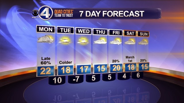
Snow amounts will range 1-3" inches in southern hometowns where there will be a longer period of sleet mixed in.  Again, a little freezing rain is possible (esp. along and south of Hwy 34).  3-5" can be expected in the northern 2/3 of the viewing area, with a few areas picking up more than 5".  Any shift in the track in either direction could change these totals slightly.
Presidents' Day 2014 (Washington's Birthday)
Again, the bulk of the snow should be done by middle to late afternoon (west to east).  Travel may be difficult Monday night, as area road crews work to get the snow cleared off.

Tuesday is shaping up to be a nice day with mostly sunny skies and temperatures near 40°.  We'll keep temperatures near or above 40° through the rest of the week, so some of the snow that is on the ground will melt.  The bad part?  Temperatures will still drop below freezing during the overnight hours, so re-freezing could become and issues, as well as fog.  We'll cross that road when it gets here.

Thanks for checking out the CBS4 Weather Blog!