You'll see some of these stats in Anthony's earlier post A Warm Start to October and here are a few bonus October climate numbers for the Quad Cities. We'll start off in the temperature department:
Average Temps
1st - 70°/47°
31st - 58°/38°
Overall average for the entire month - 53.2°
Hottest - 95° on October 3rd, 2006
Coldest - 11° on October 28th, 1925
Precipitation Stats
Average Rainfall - 2.97"
Average Snowfall - 0.00"
Wettest October on record - 9.41" in 1941
Driest October on record - 0.01" in 1964
Snowiest October on record - 6.6" in 1964

Monday, September 30, 2013
A Warm Start To October
September 2013 will be remembered for above average temperatures (more than two degrees) and below average rainfall (more than two inches).

October will get off to a very warm start with high temperatures for the first two days about 15 degrees above average in the mid-80s.
October ranks behind November (first) and September (second) and just ahead of December (fourth) as the month with the biggest drop in average temperatures from the beginning of the month to the end of the month.
In October, the averages on the first day of the month are 70° and 47°. By Halloween, those drop to 58° and 38°.
A typical October sees about 2.97" of rain in the Quad Cities.
CBS4 Meteorologist Anthony Peoples
Sunday, September 29, 2013
What Causes Leaves To Change?
Fall is here and leaves are rapidly beginning to change colors on some tress across the area. Here is a map showing the peak fall foliage across the midwest. Here in the QCA, we've got our peak colors coming up in the next few weeks!
So, what makes these leaves change color? All leaves have color pigments within their "body." Carotenoids, Anthocyanin and Chlorophyll are the three pigments which give leaves their colors. Carotenoids give leaves the yellow, brown and orange color you see in Autumn. Anthocyanin is the pigment that gives off the vibrant reds. Chlorophyll is what keeps the leaves green during the Spring and Summer. This means that the breaking down of chlorophyll causes the other pigments to take over. During night time, chlorophyll production slows and stops. Production is halted even more during Autumn when night time is longer and cooler, leading to a fast breakdown of chlorophyll.
How does the weather affect the leaves? Warm days with sunshine and cool night (not freezing) are the perfect formula for vibrant Autumn colors. If spring-like weather occurs a little later than usual or there is a severe summer drought, leaves may change a little later than usual and may not be as colorful. An unusually wet spring can also lead to awesome Fall colors. Here in the QC, we've dealt with both a wet Spring and drought conditions in Summer, so it's hard to determine at this point. But I can tell you I've noticed color on some trees across the area.
For a little more in depth on why leaves change, and to see what colors you can expect for your tree...CLICK HERE.
 |
| Times to expect peak color on trees. |
How does the weather affect the leaves? Warm days with sunshine and cool night (not freezing) are the perfect formula for vibrant Autumn colors. If spring-like weather occurs a little later than usual or there is a severe summer drought, leaves may change a little later than usual and may not be as colorful. An unusually wet spring can also lead to awesome Fall colors. Here in the QC, we've dealt with both a wet Spring and drought conditions in Summer, so it's hard to determine at this point. But I can tell you I've noticed color on some trees across the area.
For a little more in depth on why leaves change, and to see what colors you can expect for your tree...CLICK HERE.
Saturday, September 28, 2013
Latest Rain Totals
Saturday started off mostly sunny with warm, southerly winds. The high temperature was 81°, recorded at 10:56AM. From there, clouds began to move into the picture, cooling temperatures down. Clouds then gave way to rain just ahead of a cold front that swept through the metro around 6:30 Saturday evening.
The heaviest of the rain fell west of the Mississippi River, with a general tenth of an inch to third of an inch. As the cold front continued its trek to the east it began to lose some of its forcing, allowing some of the rain to dissipate, hence the lower rain totals.
While we didn't receive a beneficial rain this time around, there are promising signs of a good rain by the end of next week. Here's WPC's outlook valid through next Sunday.
The cause of the rain will be another cold front. This is still 5 to 6 days away, so we'll keep you updated through the next week on CBS4 and cbs4qc.com.
 |
| Rain through 9PM September 28th, 2013 |
While we didn't receive a beneficial rain this time around, there are promising signs of a good rain by the end of next week. Here's WPC's outlook valid through next Sunday.
 |
| WPC shows over an inch of rain possibly across the are through next Sunday. |
Friday, September 27, 2013
Weekend Rain Chances
On Thursday, Anthony showed you the updated drought conditions for eastern Iowa and western Illinois, and they showed little improvement. We do have a chance of rain later Saturday afternoon with a passing cold front.
As you can see, the QCA is under the 0.25" to 0.50" area. I am leaning toward the low end of the stick on this one. We won't have much forcing or instability to deal with as the cold front treks through the area, but with ample moisture available we will still manage to get anywhere from a tenth to a quarter of an inch of rain.
As far as our rainfall deficit goes, we are running 1.95" below average for the month of September, and a deficit of 5.79" since June 1st. However, with the abnormally wet spring, we still run a surplus of 3.50" for the entire year.
Looking beyond Saturday---another cold front will bring rain next Thursday & Friday, bringing a cool down next weekend. Of course, that's still a week away and leaves plenty of time for fine-tuning. We'll take what we can get!
 |
| QPF (Quantitative Precipitation Forecast) from the Weather Prediction Center ending 7PM Sunday |
As far as our rainfall deficit goes, we are running 1.95" below average for the month of September, and a deficit of 5.79" since June 1st. However, with the abnormally wet spring, we still run a surplus of 3.50" for the entire year.
Looking beyond Saturday---another cold front will bring rain next Thursday & Friday, bringing a cool down next weekend. Of course, that's still a week away and leaves plenty of time for fine-tuning. We'll take what we can get!
Thursday, September 26, 2013
Another Record High?

We've set and/or tied several record highs over the last month in the Quad Cities, and we'll be fairly close to another record on Friday! The record high for Friday is 90, set back in 1990. We'll more than likely fall a little short of that, but there's been no shortage of record breaking weather over the last month...check out all these records!
August 28th - 97° - broke the old record
August 30th - 98° - tied the old record
September 9th - 99° - tied the old record
September 10th - 97° - broke the old record
September 14th - 39° - tied the record low
September 19th - 93° - tied the old record
That's right - 5 record highs tied or broken and a record low tied for good measure, all since August 28th!
Drought Conditions Worsen This Week
The updated U.S. Drought Monitor report just came out today and it shows that a moderate and severe drought is still taking place across much of Illinois and Iowa.

In western Iowa, conditions have even worsened to the "extreme drought" category. That covers 2% of the state. Meanwhile, the "severe drought" coverage has dropped about 5% over the past week, but 79% of the state is now experiencing a "moderate drought", up 6% from last week.
In Iowa, 95% of the state is still "abnormally dry".

Across the Mississippi River in Illinois, 87% of the state is "abnormally dry", which is up 6% over the past week.
41% of the state is in a "moderate drought" and the area covered by a "severe drought" increased from 10% to 15% this week.
While rain is expected across Iowa and Illinois Saturday and Saturday night, amounts are only expected to be around one-quarter to one-half of an inch.
Needless to say, next week when these numbers are updated, the drought will likely worsen.
CBS4 Meteorologist Anthony Peoples
Wednesday, September 25, 2013
Is It Too Early To Snow???
High temperatures since autumn started Sunday have been in the 70s. The highs today through Saturday will likely be in the 80°-83° range, which is about ten degrees above average. It was much different this week last year.
 By this time in 2012, we already had our first "Freeze Watch" (the blue shading) and a record low of 30° on September 24th.
This September, the coldest temperature, officially, in the Quad Cities is 39° back on the 14th.
If that doesn't put a chill in you and make you thankful that it's still nice and warm out there, it was on this date back in 1942 that the Quad Cities experienced its early measurable snowfall on record of 0.1"!

While only 0.1" accumulated in the Quad Cities, some parts of Iowa saw up to 4" of snow!
Rain is possible Saturday and Saturday night, but no snow is in the CBS4 7-or-10-day forecast.
CBS4 Meteorologist Anthony Peoples
Monday, September 23, 2013
Folklore Forecast For the Next Three Months
If you believe in folklore or if you just find it interesting, the weather late last week and this past weekend may tell us what to expect in October, November, and December.
We just experienced "Ember Days", a religious period that occurs four times a year that includes fasting and prayer.
It's said that the weather on September 18th will tell us what kind of weather to expect in October; the weather on September 20th forecasts November's weather; and December's weather is based on September 21st weather.
If that's the case, here's what you can expect based on folklore.
October would be very warm and wet, November would be dry with average temperatures, and December would be colder than normal and dry.
Again, this is folklore and not an actual forecast.
CBS4 Meteorologist Anthony Peoples
Sunday, September 22, 2013
Autumn is Here!
Fall officially began today (Sunday 9/22) at 3:44pm. That time is the exact moment the sun's rays were shining directly over the Equator, giving equal sunlight to both the Northern Hemisphere and Southern Hemisphere. This occurs when the Earth's 23.5° axis is tilting neither toward or away from the sun. This is where seasons come into play! When the axis points toward the sun, we have Summer. When Earth's axis points away from the sun, we have Winter. When it is pointing neither toward or away, you have your Vernal (Spring) and Autumnal (Fall) Equinox (appx. equal day & night). For more on the Autumnal Equinox, click here.
From now until December 21st, the hours of daylight will be getting shorter, which means the temperature will be getting cooler. I put together a graphic showing the averages for the first and last day of Fall, as well as the average first day of frost in the Quad Cities.
While temperatures usual cool during Fall, the first full week of the new season will feature a gradual warm up, with temperatures near 80° by the end of the week. Catch your full forecast online anytime at www.whbf.com/weather.
From now until December 21st, the hours of daylight will be getting shorter, which means the temperature will be getting cooler. I put together a graphic showing the averages for the first and last day of Fall, as well as the average first day of frost in the Quad Cities.
 |
| High temperatures on average drop 41° over the next three months, while lows cool 34°! |
Saturday, September 21, 2013
Cool Start for QC Marathon
Sunday marks the 16th annual Quad Cities Marathon. The 26.2 race course covered all four cities, three bridges, two states and one island! Whether you're taking part in the one mile run, 5K, 5 person relay, half or full marathon, the weather looks ideal for running with temperatures in the mid and upper 40s by race time at 7:30am!
 I decided to look up the conditions for the last 5 years of the race and compare to what runners will face tomorrow. Here are the low temperatures, high temperatures, and peak wind speeds during the last five marathons:
2012: 33/63-- 30 mph (Just one degree shy of a record low!)
2011: 44/61-- 12 mph
2010: 47/65-- 24 mph
2009: 50/79-- 41 mph (That must have made for an interesting time on the bridges)
2008: 54/76-- 15 mph
Overall it's not a terribly cool start to the race, and the winds look to be from the east at 5 mph or less! If you're running any leg of the race...good luck and more importantly, HAVE FUN!
Friday, September 20, 2013
Any Rain is Good News
Another rain event is in the books, and while any rain is good new, it didn't do much as far as our deficit goes.
The showers & thunderstorms brought damaging winds and small hail across some hometowns, especially northwest of the Quad Cities, as well as heavy rainfall in some spots. The storms formed ahead of a cold front that swept through the area Friday, leaving us with a cooler, more fall-like pattern.
Check out the some of the rainfall totals from across the area:
 Since June 1st, the airport in Moline has seen 10.34" of rain, and that is just over 5 inches below average, which is why we are still classified under a "Severe" drought. Right now, the next six days are looking dry. There is another chance for rain along a cold front that rolls in NEXT weekend. Of course, timing of that system will be key.
Here is an area-wide plot of the Thurs. night/Fri. morning rainfall totals:

The showers & thunderstorms brought damaging winds and small hail across some hometowns, especially northwest of the Quad Cities, as well as heavy rainfall in some spots. The storms formed ahead of a cold front that swept through the area Friday, leaving us with a cooler, more fall-like pattern.
Check out the some of the rainfall totals from across the area:

Here is an area-wide plot of the Thurs. night/Fri. morning rainfall totals:

Unprecedented Iowa Weather!
It's Friday and I have to share something that might make you smile as we head into the weekend.
Automated weather observations make gathering weather information much easier and quicker to analyze when putting together a forecast.

All Friday morning during "CBS4 News This Morning", I wondered why there was a big darkish blog over northeastern Iowa. These are "isotherms", contour lines on a map showing locations with the same temperature. And, on this map, the green indicates cooler temperatures and the closer to red you get, the warmer.
There was no real explanation for it since the temperatures were in the upper-50s and low-60s. However, upon closer inspection, I found the problem. Here is a snapshot of the Monticello Municipal Airport weather conditions.

At 8:15 a.m. Friday, the weather sensor was reporting a temperature of 129°! Take that, Death Valley, California. If that wasn't bad enough, the dew point was reported at 127°!
A dew point that high has never been achieved. The world record highest dew point was 95° on July 8, 2003, in Saudi Arabia. When combined with the high temperature of 108° that afternoon, the heat index reached 174°.
However, with Monticello's automated malfunction, its heat index was 459° Friday morning!!!!!!! Good thing it's a malfunction.
Just a little weather humor to share today. Have a great weekend!
CBS4 meteorologist Anthony Peoples
Thursday, September 19, 2013
Drought Getting Worse in Illinois
While some much needed rain is on the way later today and tonight, the drought is worsening across Illinois while it's about the same as last week across Iowa.
The U.S. Drought Monitor shows that 81% of Illinois is experiencing "abnormally dry" conditions compared to 66% last week.
42% of the state is now in the moderate drought category up 2% from last week, while 10% of Illinois is now going into a severe drought. Last week, only 4% was in a severe drought.
 In Iowa, all of the drought numbers are within a percentage point of last week.
97% of Iowa is "abnormally dry", 73% is experiencing a moderate drought and 42% is in the severe drought category.

An inch or more of rain is expected through Friday morning.
CBS4 Meteorologist Anthony Peoples
The U.S. Drought Monitor shows that 81% of Illinois is experiencing "abnormally dry" conditions compared to 66% last week.
42% of the state is now in the moderate drought category up 2% from last week, while 10% of Illinois is now going into a severe drought. Last week, only 4% was in a severe drought.

97% of Iowa is "abnormally dry", 73% is experiencing a moderate drought and 42% is in the severe drought category.

An inch or more of rain is expected through Friday morning.
CBS4 Meteorologist Anthony Peoples
Wednesday, September 18, 2013
Warm Tomorrow, But No Record
More rain is on the way to the Mississippi and Illinois Valley through Friday, but so are warmer temperatures. Highs today will make it into the low-to-mid-80s and the upper-80s Thursday.

That 88° projected high Thursday in the Quad Cities will fall short of the 93° record high for the date.
From this point on, the record high temperature in the Quad Cities is 99° and that occurred on September 29, 1953.
For October, the record high is 95°. That was achieved on October 3, 2006.
In the Quad Cities, the record high for the month of November is 80° and that was reached on two occasions, both on the first day of the month -- the first time was in 1933 and the second time was in 2000.
And, for December, the record high in the Quad Cities is 71° on December 4, 1998.
CBS4 Meteorologist Anthony Peoples
Tuesday, September 17, 2013
Rain in the Forecast
It sure was nice to pick up some rain over the weekend, and now there's another good chance for wet weather coming up this week! While there's a slight chance for showers and t'storms late Tuesday night and early Wednesday, then again late Wednesday and early Thursday, the best chance for rain this week is Thursday night and Friday. A strong cold front will slam into the area late Thursday, creating a very good chance for showers and t'storms which could end up dropping close to an inch of rain.
Here are a couple forecasts from the NWS WPC - one shows rain totals from Thursday evening through Friday evening while the other shows rain totals for the next 5 days...
While this certainly won't end our drought it would at least stem the tide from the last couple months!
Here are a couple forecasts from the NWS WPC - one shows rain totals from Thursday evening through Friday evening while the other shows rain totals for the next 5 days...
 |
| Thursday night/Friday |
 |
| 5 day total |
Monday, September 16, 2013
The Weekend Chill Eases
In just the past week, the Quad Cities tied a record high of 99° last Monday and then tied a record low of 39° Saturday morning.
For the first half of September, temperatures at the Quad City International Airport in Moline, Illinois, are running 3.2° above average.
After a couple more cooler than average days today and tomorrow, the heat returns midweek with highs back into the 80s.
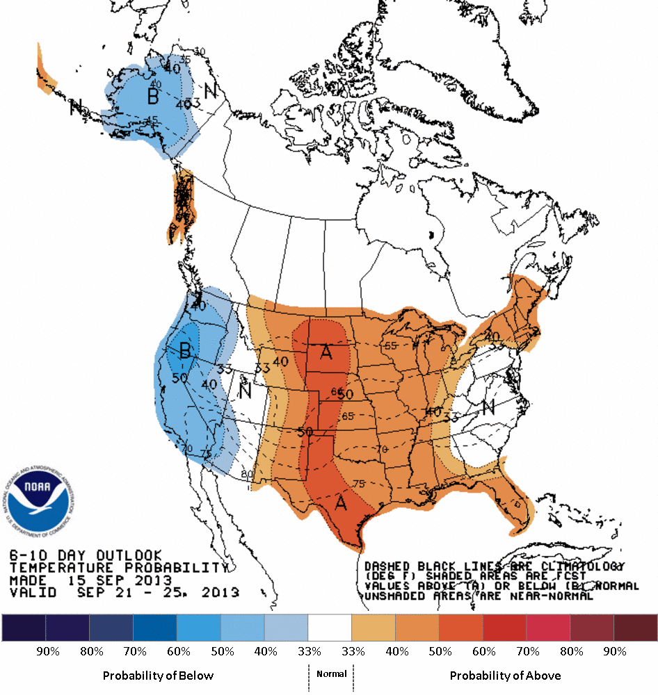
My 10-day forecast shows average or above average temperatures continuing through September 25th and NOAA's Climate Prediction Center seems to agree.
This first map is for September 21-25, 2013.

And, looking out through September 29th, the warmth will stick around for us.

So, for those of you that broke down and turned the heat on this past weekend, you'll be able it off and maybe open the windows.
As for 2013, only January and May saw above average temperatures. Through the end of August, 2013 temperatures are running about 1.4° below average.
CBS4 Meteorologist Anthony Peoples
For the first half of September, temperatures at the Quad City International Airport in Moline, Illinois, are running 3.2° above average.
After a couple more cooler than average days today and tomorrow, the heat returns midweek with highs back into the 80s.
My 10-day forecast shows average or above average temperatures continuing through September 25th and NOAA's Climate Prediction Center seems to agree.
This first map is for September 21-25, 2013.
And, looking out through September 29th, the warmth will stick around for us.

So, for those of you that broke down and turned the heat on this past weekend, you'll be able it off and maybe open the windows.
As for 2013, only January and May saw above average temperatures. Through the end of August, 2013 temperatures are running about 1.4° below average.
CBS4 Meteorologist Anthony Peoples
Sunday, September 15, 2013
Finally...Much Needed Rain!
Finally, a widespread rain event for the viewing area! We had an area of low pressure and associated cold front move through the area Sunday, bringing some beneficial rainfall.
Here are a few other reports from across the area: Elizabeth, IL (Jo Daviess Co.)-- 0.19"; Mount Carroll, IL-- 0.92"; Davenport, IA-- 0.81"; Dubuque, IA--0.35".
WHERE WE STAND
For 2013 (through 9/15), the airport in Moline has seen 33.12" of precipitation. Normally we should only have 28.79". That puts us at a 4.33" surplus for the year! BUT, since June 1st (through 9/15) we've seen 9.97" of rain. The average amount for the same period is 14.93", so that puts us 4.96" below avg. for the 3.5 month period. Fortunately for lawns, farmers' crops, and gardeners' plants -- there is a good chance for rain late Tuesday night through early Friday morning! Here is the Weather Prediction Center's QPF (quantitative precipitation forecast) valid 7PM 9/15 through 7PM Wednesday.
While that is not set in stone, it certainly looks like a possibility! We'll keep you updated throughout the week on CBS4 and www.whbf.com/weather
 |
| As expected, the heaviest rain fell north of I-80 & most areas saw 0.25" to 0.75" |
WHERE WE STAND
For 2013 (through 9/15), the airport in Moline has seen 33.12" of precipitation. Normally we should only have 28.79". That puts us at a 4.33" surplus for the year! BUT, since June 1st (through 9/15) we've seen 9.97" of rain. The average amount for the same period is 14.93", so that puts us 4.96" below avg. for the 3.5 month period. Fortunately for lawns, farmers' crops, and gardeners' plants -- there is a good chance for rain late Tuesday night through early Friday morning! Here is the Weather Prediction Center's QPF (quantitative precipitation forecast) valid 7PM 9/15 through 7PM Wednesday.
 |
| This graphic indicates 0.50"-0.75" of rain area wide! |
Saturday, September 14, 2013
One Extreme to the Next
It has been quite the week of weather in the Quad Cities. Monday & Tuesday met or broke their respective record highs (99° Monday & 97° Tuesday). Wednesday, the Quad City International Airport saw its first measurable rain in 36 days, tied for the 3rd driest stretch on record (longest stretch was 45 days)! Burlington also ended their longest dry stretch of 42 days on Wednesday. More beneficial rain is expected across much of the area Sunday.
The rain was associated with a cold front on Wednesday, which slowly cooled temperatures into the 70s to round out the week. Friday night was a clear night, allowing for all the radiation from the day to escape back into the atmosphere, cooling temperatures off in the upper 30s to lower 40s all across the area! The Quad Cities tied the record low temperature of 39° set back in 1974!
The average high for this time of year is 78°, while the average low is 55°. By the end of the month those averages go down to 71°/48°.
The rain was associated with a cold front on Wednesday, which slowly cooled temperatures into the 70s to round out the week. Friday night was a clear night, allowing for all the radiation from the day to escape back into the atmosphere, cooling temperatures off in the upper 30s to lower 40s all across the area! The Quad Cities tied the record low temperature of 39° set back in 1974!
 |
| A 60° temperature swing in just five days in the Quad Cities! |
Friday, September 13, 2013
Soaking Rain Possible Late In The Weekend
Even as a moderate to severe drought is taking place across parts of Iowa and Illinois, the Quad Cities are still running more than four inches above average on precipitation in 2013.
That's deceiving because we had 21.32" collectively for the months of April, May, and June. That means for the other five months and the first part of September, we've only had a total of 11.38"!
In the first six months of 2013, we had a total of eighteen days with 0.50" or more of rain. Okay, to be technical, 17 daily rain events and one rain and snow event that melted down to 0.50" or more.

On Sunday, we could have another rain event that might bring one-half inch or more. This is big news because we only had four days in July with 0.50" or more of rain and none in August or the first part of September.
Of the 22 daily events with 0.50" or more of precipitation in the Quad Cities in 2013, eight were more than one inch! One was in March, three in April, three in May, and one in June.
The one in June, on the 24th, was an incredible 4.46"!
Have a great weekend!
CBS4 Meteorologist Anthony Peoples
Thursday, September 12, 2013
Latest Drought Monitor Released
Parts of the Quad Cities area saw measurable rainfall along & behind a cold front Wednesday, which ended the stretch of abnormally dry weather. While the QC Airport saw measurable rain, it was only 0.09", which barely does anything for drought conditions.
Here are the latest drought conditions for Iowa & Illinois (information valid through September 10th):
 Moderate and severe drought have increased in coverage across the state of Iowa. Last week, 63.24% of the state were classified as D1 (Moderate); this week 72.30% of the state is classified in "Moderate." Areas in "Severe" drought increased from 32.07% last week to 41.79% this week.
 The situation isn't much better in Illinois. As you can see, parts of the QC area are classified as "Severe" drought. The Severe, Moderate and Abnormally Dry categories saw an increase within the last week.
Fortunately, there is some rain in the forecast later this weekend and early next week. Early indications show some areas could see at least a quarter of an inch, and there may be a little more coverage across the area. Of course, we'll fine tune that forecast as the date gets closer.
Here are the latest drought conditions for Iowa & Illinois (information valid through September 10th):


Fortunately, there is some rain in the forecast later this weekend and early next week. Early indications show some areas could see at least a quarter of an inch, and there may be a little more coverage across the area. Of course, we'll fine tune that forecast as the date gets closer.
Wednesday, September 11, 2013
Finally, Some Measurable Rain in the Quad Cities
We saw a few rain drops falling from the skies across eastern Iowa and northern Illinois Wednesday afternoon. Some of you saw nothing, some a few sprinkles, and some a few downpours.
0.02" of rain officially fell at the Quad City International Airport in Moline, Illinois, ending our 36-day stretch with no measurable rain.

However, in Burlington, Iowa, while you may get a shower this evening or tonight, as of 4 p.m. Wednesday, you were were still dry. If you make it to midnight with no rain, this will be the 43rd consecutive day with no measurable rain there.
If you miss out on the rain this time around, hang on. There's still a decent chance of showers coming in late Saturday night and Sunday.
CBS4 Meteorologist Anthony Peoples
Record September Heat
The record heat that the Quad Cities area has seen in the last few days will finally come to an end as a cold front sags through the area on Wednesday, bringing with it the chance for some scattered showers and t'storms.
 As you can see, the record was tied on September 9th, and broken on September 10th. Factoring in the humidity, it felt more like 100° to 105°!
Burlington also saw record highs on September 9th & 10th. The record high was tied at 100° on 9/9, which was previously set in 1912. On 9/10, the mercury reached 98°, beating the old record of 97° set back in 1933!
Once the cold front moves through, temperatures are going to cool down into the lower 70s by the weekend, which will feel nice and refreshing! No 90 degree temperatures in site.
Tuesday, September 10, 2013
Quiet Hurricane Season (So Far...)
While we are making the top 5 list of the longest dry stretch (today will be the 36th consecutive day---tied for #3), that Atlantic hurricane season is nearing its latest first date to have a named hurricane. The average first hurricane occurs on August 10th. The latest hurricane on record to form in the Atlantic Basin was "Hurricane Gustav", which was named a hurricane on September 11th, 2002.
There are currently two named storms spinning about; Tropical Storm Gabrielle near Bermuda & Tropical Storm Humberto near the Cape Verde islands. Neither have a threat to make landfall in the United States. However, Humberto has a good chance of becoming a hurricane later today (courtesy of the National Hurricane Center).
 If Humberto does NOT strengthen into a hurricane today, then there is a possibility to tie the latest first date if the storm strengthens tomorrow.
Being that today is the "peak" of the season, there is still plenty of time left for tropical systems to develop in the Atlantic. Hurricane season runs through November 30th.
The last hurricane to make landfall in the United States was Hurricane Wilma on October 24th, 2005 in Cape Romano, FL; at one point, the strongest hurricane every in the Atlantic Basin with a central barometric pressure at 882milibars and winds of 185mph!
Monday, September 9, 2013
90s in September?
So far this September, we have had one day where it was 90° or warmer, and that was on September 6th when the mercury reached 92°. Today & Tuesday will feature temperatures in the mid to upper 90s, and with the added humidity it will feel closer to 100°.
So how common are 90s in September? The average number of days in September where the temperature reaches 90° or above is 2.1; statistics taken from 1981-2010. Here's a look at 90° temps over the last six years:

So how common are 90s in September? The average number of days in September where the temperature reaches 90° or above is 2.1; statistics taken from 1981-2010. Here's a look at 90° temps over the last six years:
2013: 1; 9/6, 92° (as of 9/8)
2012: 2; 9/3, 95°; 9/4, 93°
2011: 2; 9/1, 90°; 9/2, 92°
2010: 2; 9/6, 90°; 9/21, 90°
2009: No days at or above 90°
2008: 2; 9/1, 90°; 9/2, 91°
As you can see, it isn't unheard of to see 90s in September. By Wednesday, we should have three 90 degree days for the month under our belt.
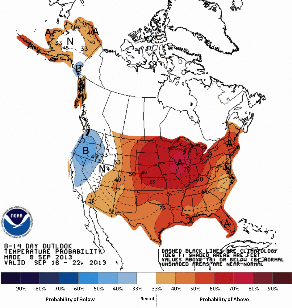
This weekend temperatures will drop into the mid 70s, and we could have lows in the upper 40s in some spots! But, the 8-14 day temperature outlook shows temperatures could be above average for much of the period:
As far as rain goes...nothing to get too excited about, unfortunately. Monday (9/9) will mark the 35th consecutive day with no measurable rainfall at the Quad City International Airport.
Sunday, September 8, 2013
Heavy Storms Early Sunday To The South
Sunday marked the 34th consecutive day with no measurable rain in the Quad Cities at the Quad City International Airport.
This is the 5th longest stretch without measurable rain in Quad City weather history. A rainless Monday will push us up to number four and if we don't see measurable rain Tuesday, that would put us in a tie for third place.
While we can't get more than a few drops of rain in the Quad Cities, it was a much different story early Sunday morning in our southern hometowns.

This picture here was submitted by Ethan Schisler of the intense lightning around Galesburg, Illinois.
Officially, Galesburg picked up 1.18" of rain. However, some parts of McDonough and Warren counties in west-central Illinois, picked up three to four inches of rain!
Our next chance of showers and thunderstorms arrives Tuesday night and Wednesday.
CBS4 Meteorologist Anthony Peoples
Saturday, September 7, 2013
When Will it Rain?
Saturday (September 7th) marked the 33rd consecutive day without any measurable rain at the airport in Moline. We did receive a trace of rain on August 7th---one month ago. Either way you slice it, drought conditions are not getting any better. This ranks as the 5th longest dry streak in recorded QC weather history! Will we break that record?
 Looking at the latest guidance, we do have a slight chance of rain along a cold front by the middle of the work week. The question is; Where? When? How much? Here is a comparison between 4 different models. The bottom two and top right are all valid at 1am Wed. morning. The top left is an older run of the ECMWF (European) model, showing the best chances of rain around 1pm Wednesday. As you can see, all four models are not exactly in agreement on how much rain we will get, as well as when & where it will occur. The CBS4 weather team will keep you updated as the system gets closer. As for the long range (8 to 14 days out)? Here's what the Climate Prediction Center has to say:
 Prior to the front moving in, temperatures will soar back into the lower and mid 90s to start the work week. Once the front moves through (rain or no rain), temperatures will cool back into the 70s by next weekend, which will be quite the refresher!


Thursday, September 5, 2013
Drought Is Getting Worse
The drought conditions across Illinois and Iowa are worsening. If it doesn't rain in the Quad Cities today, it will be the 31st consecutive day without measurable rain.

In the update from the U.S. Drought Monitor, 39% of Illinois is now in a "moderate drought", which is up from 21% last week.
2% of the state, including Hancock, Henderson, and Mercer counties are now in a "severe drought". Last week, no part of Illinois was in that category.

In Iowa, while the percentage of the state in a "moderate drought" increased slightly this week to 63% from 60% last week, the big story is the spike in the percentages under a "severe drought".
This week, 32% of the state falls into that category, which is depicted in the darker shading in the map above. Last week, only 22% of the state was in a "severe drought".
CBS4 Meteorologist Anthony Peoples
Tuesday, September 3, 2013
Lack of Rain Is One For The Record Books
Tuesday marks the 29th consecutive day with no measurable rain at the Quad City International Airport in Moline, Illinois, the official reporting station for the Quad Cities.
Our last measurable rain was on August 5, 2013, when 0.49" fell.
So, where does this place us in the record books?
# of days with Streak ended on:
no measurable
rain
1. 45 11/15/1952
2. 40 01/23/1944
3. 36 11/21/1999
4. 35 01/06/1940
5. 32 09/17/1893
6. 31 02/05/1919
7. 30 12/10/1904
8. 29 **2013** (still going on )
9. 28 07/10/1989
9. 28 09/23/1979
9. 28 01/19/1954
While there are very slight chances of rain (less than 10%) in the forecast, it looks like the best bet of seeing rain is not until the middle of next week. If it doesn't rain before then, that could push us up to #3.
CBS4 Meteorologist Anthony Peoples
Monday, September 2, 2013
September Stats

I hope everyone enjoyed the beautiful weather on Labor Day, temps were very close to normal for early September. Now that we're into the 9th month of the year here's a look at some September climate stats for the Quad Cities:
Temperatures
Avg on the 1st - 82/60
Avg on the 30th - 71/48
Hottest Sept temp ever: 100° on September, 6, 1922 and September 15th, 1939
Coldest Sept temp ever: 24° on September 28, 1942
Last September's overall average temperature was 62.7° compared to the normal Sept average temperature of 65.4°.
Precipitation
The average rain in the month of September is 3.09". In September 2012 we picked up 2.19" of rain as we continued the drought of 2012. The wettest September ever in the Quad Cities was in 1970 when we received 14.18" of rain! The driest September ever? That was 1979 when it barely rained at all (0.02"!)
Sunday, September 1, 2013
August: A Look Back
As we wrap up the 8th month of the year, it's time to take a look back at the month, weather wise!
August 2013 will go down as the 9th driest August in the Quad Cities, with only 0.76" of rain. The rain came in two rounds; 0.27" on August 2nd, and 0.49" on August 5th (which was also the coolest day of the month, with a high of 74°). A trace of rain was recorded on August 7th, but that does not qualify as "measurable" (a trace of rain is less than one hundredth of an inch of precipitation). That puts as at -3.76" below avg!

The Quad Cities wasn't the only area with dry weather, many folks to the south also saw little, if any rain in August. Burlington saw just a TRACE of rain, making August '13 the driest August ever! Other areas seeing a trace or less of rain include (via National Weather Service QC): Mt. Pleasant, IA; Muscatine, IA; Ft. Madison, IA; Lone Tree, IA; New Boston, IL; Dallas City, IL. The map below is from the Midwest Regional Climate Center showing areas in yellow-orange that saw less than 0.01" if rain in August.

Back in the metro area, the warmest maximum temperature was 98°, which occurred this past Friday, Aug. 30th! The coolest minimum temperature was 47° on Aug. 14th.
September 1st marks the first day of Meteorological Fall, which spells the end to the 3 hottest months of the year. Fall is just 21 days away, beginning at 3:44pm on September 22nd (Autumnal Equinox). Looking at the first 10 days of September, temperatures will be at or slightly above average. As far as precipitation is concerned...still looking dry! Get your 7 Day forecast online anytime at www.whbf.com/weather!
Subscribe to:
Comments (Atom)