Monday, February 28, 2011

Tied the Record


We only needed .1" of snow over the last 24 hours to BREAK the record for February snow, instead we'll have to settle for a tie with 1994. On the strength of the early month blizzard we ended up with 20.7" of snow in the QC during February!

A Nice Day


After all the sleet and freezing rain last night it's been nice to soak up some sunshine today! Clear skies can be found all across the area, and tomorrow looks very nice as well! Not only can we count on more sunshine, temperatures should be a little warmer Tuesday!

(Back into the 40s tomorrow!)

Saturday, February 26, 2011

We Tied The Record For Snowiest February!

NWS: RECORD MONTHLY SNOWFALL SET AT MOLINE IL... THROUGH 6 PM...THE SNOWFALL TOTAL AT MOLINE IL TODAY WAS 0.3 INCHES.THIS BRINGS THE MONTHLY SNOWFALL TOTAL TO 20.7 INCHES. THIS TIES THEOLD RECORD OF 20.7 INCHES SET IN FEBRUARY 1994.

More Wet Weather On The Way!


Friday, February 25, 2011

Snow Reports


With more light snow on the way for this weekend here's a quick look back to the snow from Thursday night. In the QC the official total was 1.9". Most places picked up between 1 and 2 inches, with a few places closer to 3 inches! Have a good weekend, and be on the lookout for a little more light snow Friday night and Saturday, and then heavy rain is possible by Sunday!

Snow Update


Here's the latest as the snow begins to pull East tonight. It took a little while for the snow to saturate the lower levels of the atmosphere and that's why the onset of the snow was delayed by just a bit this evening. It's looking like most places will pick up a quick couple inches of snow, with a few reports of up to 4 inches not out of the question. Another round of light snow could develop Friday night and Saturday. Snow totals can be found Friday on CBS4 News at 5!

Thursday, February 24, 2011

Snow Forecast Update


With snow set to begin this evening I've settled on a forecast of 3-5 inches of snow in the QC through Thursday night and early Friday. Heavier snow will fall around Galesburg, Peoria, Monmouth and Kewanee...where we can expect 5-8 inches of snow! Advisories and warnings are in effect for tonight so take it easy if you have to be out traveling! It's looking like yet another February night to stay inside if possible...Here's the primetime lineup for CBS4 tonight:

7 -8 pm Big Bang Theory and Rules of Engagement
8-9 pm CSI
9-10 pm The Mentalist
10 pm Ten at 10

Snow Forecast Going Up...


As tonight's winter storm takes a path that's further North our predicted snow goes up dramatically! Earlier this week it was looking like the heaviest snow would stay well South of the QCA, now though heavy snow is likely from the Quad Cities to Galesburg, with lighter totals North of the QC.

Quad Cities - 3-6"
Galesburg - 5-7"

This map from the NWS HPC shows the likelihood of picking up more than 4 inches of snow...in the QC it's a moderate risk!

Wednesday, February 23, 2011

Wintry Weather


Here's a look at active weather watches/warnings/advisories across the country...where you see the purple and blue colors around the QC that's where Winter Weather Advisories and Winter Storm Watches are in effect! All the green shadings are for Flood Warnings!

An Interesting Evening...


It was quite the evening in the QC! WE had a little bit of thunder and lightning, as well as rain, sleet, snow and HAIL! Here's a shot from our ESP:Live Radar, showing the heavy stuff has moved away from the QC. We could still see some light drizzle though, and with temps close to freezing a few icy spots are not out of the question.

Also, notice the picture taken from here at CBS4...looking across the street toward the US Bank in Rock Island, with hail/sleet covering the ground!

Tuesday, February 22, 2011

Accumulating Snow Thursday Night/Friday?


We've been tracking another winter storm that could affect the area Thursday night and Friday. Right now it still looks like we could see a mixture of rain/snow changing to all snow, with some respectable accumulations possible. If the precip falls as all snow we could see up to 6 inches or so! Here's a graphic from the NWS HPC depicting the chance for 4 inches or more of snow, the QC is included as a 'slight risk.'

Monday, February 21, 2011

Late Week Storm


After some very light snow Monday night things will quiet down for Tuesday and Wednesday...and then we need to be ready for another winter storm late this week! It's looking like the eventual track of this next weather-maker will be close enough to us that we'll see rain and snow. If the storm tracks a little further South we could be looking at accumulating snow Thursday and Friday. Here's one forecast model (ECMWF) that suggests a track that's further...SOUTH!

Friday, February 18, 2011

Quiet Start to the Weekend


After some nice weather Thursday and Friday our weekend is getting off to a quiet start. The end of the weekend will be anything but quiet though! Rain develops Saturday night and lasts off and on through Sunday. At times we could even hear a little bit of thunder mixing in! The good news is this time around most of the heavy snow will stay north of us in Minnesota and Wisconsin!

Thursday, February 17, 2011

Almost There...


The record high today in the QC is 62°...as of 2pm we are sitting at 60°! If we squeeze in just a little bit of sunshine we should break the record!


UPDATE - THE OFFICIAL HIGH ENDED UP AT 63° IN THE QC!

Almost Gone...


The snow continues to disappear around town, and by the time this map updates tomorrow the snow line (snow cover) should be well North of the QC!

Wednesday, February 16, 2011

Snow Depth Dwindling...


Snow continues to melt around the QC, and around a large part of the country as we enjoy unseasonably warm weather! Here's the latest snow depth report.

Monday, February 14, 2011

Another Nice Day


Snow continues to melt away today as we have temperatures in the 40s with sunny skies! Expect even warmer weather through the middle of the week, with a cool-down expected this weekend. Spring isn't too far away though, can you feel it?!?!

Saturday, February 12, 2011

Happy Birthday President Lincoln!


Abraham Lincoln was born 202 years ago! Here's to the Land of Lincoln!

Friday, February 11, 2011

Warmer Weather in Sight!


Finally! After a brutal stretch of cold and snow so far this season we are in for a bit of a break starting this weekend! Temperatures warm into the 30s this weekend and the 40s for the majority of next week! Let the melting begin...

Thursday, February 10, 2011

Wednesday, February 9, 2011

Tuesday, February 8, 2011

Another Wind Chill Advisory


With another very cold night on the way and light winds expected a Wind Chill Advisory has been issued again for the QC. Late tonight as temps drop below zero our wind chills will drop to about -20°! Be careful and bundle up if you're heading out late tonight or early Wednesday!

Monday, February 7, 2011

Wind Chill Advisory


A Wind Chill Advisory has been issued for the Quad Cities tonight. As temperatures drop below zero and winds continues at about 10-15 mph wind chill values will drop to -25°! This is cold enough for frostbite to form in a very short time. Be careful and bundle up if you're heading out late Monday night or early Tuesday!

Cold, Then Warming Up!


Our roller coaster ride of temperatures continues this week in the QC. The next few days look very cold, with warmer weather set to arrive this weekend. Here are a couple images showing temperatures (up above the surface, but a good guide as what to expect as far as temperature trends) from the ECMWF (European) computer model. Notice the cold weather early this week (top image) and then warmer weather starting this weekend!

Sunday, February 6, 2011

Hometown Forecast for Monday 2/7/2011


Thanks to Larry for a great shot of a train blasting its way through a snow drift last week in Yates City, IL.

Friday, February 4, 2011

More Snow?

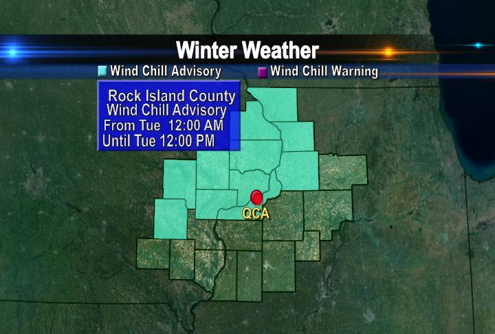
The sunshine sure has been nice the last 2 days but it looks like we could be in for some light snow late this weekend. Most of Saturday looks fine but Sunday provides another chance for some light snow. Also, it looks like the middle of February is shaping up to be very cold, as the hits just keep on coming this winter!

Thursday, February 3, 2011

Final Snow Tally

The NWS has just released FINAL snow numbers for the blizzard earlier this week...and there are some changes to the final storm totals! The NWS has added the 1.7" of snow that fell Monday to the overall storm total. This brings the 3-day storm total to a whopping 18.4" which ties the record for most snow EVER from one storm in the QC! Also, we set a record for most snow in a 24 hr period, with 16.7 inches of snow (during a 24 hr period from Tues - Wed) Here are some more numbers courtesy of the National Weather Service!

Rank Total Snow End Date
1 18.4 2/ 2/2011
1 18.4 1/13/1979
3 16.4 1/ 3/1971
4 15.1 1/19/1995
5 15.0 3/30/1972
6 14.3 1/ 3/1999
7 12.7 1/27/1967

A View From Space of Our Blizzard!

Wednesday, February 2, 2011

Send Us Your Blizzard Pics!


Feel free to send your best blizzard pics to the weather department at CBS4...the email address is: weather@cbs4qc.com

Thanks, here's one from Jenna in Bettendorf!

Early Morning QC Snow Reports!

Snow Totals from the NWS

Here are some of the latest snow reports from the NWS, check out the official total for the Quad Cities! 14.8" as of midnight!


SNOW REPORTS LISTED BY AMOUNT

INCHES LOCATION ST COUNTY TIME
------ ----------------------- -- -------------- -------
16.0 LOWDEN IA CEDAR 1222 AM
14.8 MOLINE QUAD-CITY AIRPOR IL ROCK ISLAND 1207 AM
12.0 2 WSW IOWA CITY IA JOHNSON 1154 PM
12.0 MACOMB IL MCDONOUGH 1117 PM
12.0 STRONGHURST IL HENDERSON 0850 PM
11.0 2 NNE OLIN IA JONES 1015 PM
10.8 5 S EAST MOLINE IL ROCK ISLAND 1015 PM
10.5 4 WNW SHERRARD IL ROCK ISLAND 0930 PM
10.2 DAVENPORT MUNICIPAL AIR IA SCOTT 1214 AM
10.0 DUBUQUE REGIONAL AIRPOR IA DUBUQUE 1205 AM
10.0 SOLON IA JOHNSON 1007 PM
10.0 4 SSW PRINCETON IL BUREAU 0950 PM
10.0 SW CEDAR RAPIDS IA LINN 0940 PM
9.3 IOWA CITY IA JOHNSON 0917 PM
9.0 1 SE PRINCETON IL BUREAU 0945 PM
8.2 SWISHER IA JOHNSON 1058 PM
7.0 1 WSW ELMIRA IA JOHNSON 0910 PM
7.0 SW GALVA IL HENRY 0858 PM
6.8 SE CEDAR RAPIDS IA LINN 0902 PM
6.5 SW HILLSDALE IL ROCK ISLAND 1033 PM
6.2 SWISHER IA JOHNSON 0905 PM
6.0 4 SSW PRINCETON IL BUREAU 0851 PM
5.0 QUASQUETON IA BUCHANAN 0920 PM

Tuesday, February 1, 2011

Heavy Snow


In the Quad Cities we can expect a few more hours of heavy snow, before things taper off a bit after midnight. Wednesday morning promises more light snow, but the heaviest of the snow should wind down after midnight. Totals will range from 8 inches West of the QC, to 14 to 18 inches NE of the QC...that's a slight adjustment downward due to some of the dry air working into the system from the SE...notice the Southern half of Illinois and Indiana are drying out quickly.


Remember though, winds will stay up through the night and blowing and drifting snow will continue to plague the area.

Snow Totals from the NWS

Here are some of the reports coming in to CBS4 and the National Weather Service so far...Blizzard conditions will not let up anytime soon. So far in the QC we are at 5.4" since noon!

0631 PM SNOW MACOMB 40.47N 90.68W02/01/2011
E8.0 INCH MCDONOUGH IL TRAINED SPOTTER

0623 PM SNOW 2 WSW IOWA CITY 41.65N 91.57W02/01/2011
M4.5 INCH JOHNSON IA TRAINED SPOTTER

0517 PM SNOW DAVENPORT MUNICIPAL AIR 41.62N 90.58W02/01/2011
M3.7 INCH SCOTT IA OFFICIAL NWS OBS

0557 PM SNOW 3 ENE MUSCATINE 41.44N 91.03W02/01/2011
M5.0 INCH MUSCATINE IA TRAINED SPOTTER

0600 PM SNOW MOLINE QUAD-CITY AIRPOR 41.45N 90.50W02/01/2011
M5.4 INCH ROCK ISLAND IL OFFICIAL NWS OBS PAST 6 HOURS.
SNOW DEPTH 8 INCHES.

Image of the Blizzard


Here's a picture taken from one of the doors looking out the 3rd floor of CBS4. Visibility right now is under a mile and will get worse through the evening...Feel free to send any pics from your house to weather@cbs4qc.com

Updated Snow Forecast


Few things have changed with the blizzard affecting the QC...and the changes are NOT for the better! It's looking like the storm will track a little further NW and that could bring the heaviest snows right up into the Quad Cities! From the QCs to the Southeast places could see 14 to 19 inches of snow! Refer back a couple posts on this blog and you'll see the most snow we've ever seen with one storm in the QC is a little more than 18 inches! In other words, this could end up as the HIGHEST snow total ever in the QC! Needless to say, the Blizzard Warning continues and if you travel tonight you could be risking your life...

Snow Arriving


The snow is now pushing into the Quad Cities and will continue moving North over the next few hours...The heaviest snow is still set for late this evening and overnight into Wednesday. In the Quad Cities we are still on track for more than a foot of snow and the Blizzard Warning needs no changes, as high winds and heavy snow will make travel extremely dangerous. In fact just about anything other than emergency vehicles on the road tonight will be unacceptable! More updates throughout the day coming up...

9 AM Update: Models Show More Snow For QCA!