Tuesday, January 31, 2012

2011 vs 2012


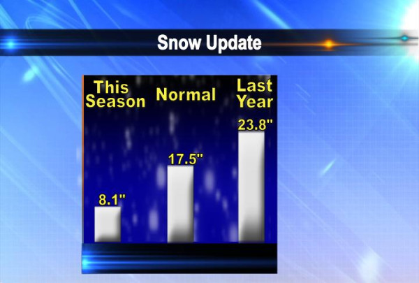
If you had to pick one or the other which one would you take? Last year's early February blizzard, or this year's beautiful early February weather? This is the forecast for this year and the recorded weather from last year when we had the BLIZZARD!

Another Record Temperature?

After a record high on Monday we fell short of the record high on Tuesday by about 10°. However, we could still set a temperature record today, it just might not be the one you think about 1st! The record warm low for January 31st is 41° from back in 1877! That means that's the warmest LOW temperature we've ever had on this date. So far today's low is 46° and if it stays above 41° thru midnight it will be another record temperature!

Will it Snow This Weekend?

9:30 PM update: The GFS is still showing its snowy scenario for the weekend, while the European model takes the storm on a track that would produce more rain for us...must keep watching!

It's still a little early to say but one of our medium range forecast models is now suggesting snow for this weekend in the Quad Cities. The GFS is suggesting a wet 4-6" of snow is possible, mainly on Saturday and winding down before the Super Bowl on Sunday. Some of you might remember the last time the Giants and Patriots played in the Super Bowl we picked up about 4-6 inches of snow during the game...Feb 3rd, 2008!

Cold Conditions for the UK


As we are having above average conditions in the QCA, our friends across the Atlantic are prepping for some colder weather. Parts of the UK are forecasted to have temperatures dropping into teens and blustery winds for the next few days. A high pressure system over Scandinavia is pushing very cold winds into the UK. The weather service has put out a level 3 severe weather warning, which prompts the military to get involved to clean roads and keep citizens safe and warm. This bout of cold weather is predicted to continue through the entire month of February. Forecasters have also predicted a few inches of snow to fall in the coming days.

The cold weather in eastern Europe has already killed 36 people with temperatures in the negative teens. This cold spell can potentially upset one of the UK's warmest winters on record. Due to the cold weather, countries in eastern Europe have had to close schools, block roadways, and loose power.

So enjoy the nice temperatures and sunny skies!

Monday, January 30, 2012

Very Cold...in Alaska

Here are the temps just before 9 pm in the QCA. Notice we're still very mild outside! I did notice the temperature in Galena, Alaska tonight, and they aren't quite as lucky as we are in the Quad Cities! It's 86° colder in Alaska's Galena than Illinois' Galena! It's very close to 3,000 miles from one to the other, so for every 30 miles the temp would drop about 1°! Any my wife would tell you, there's probably A LOT LESS shopping there also!

Record High Temperatures!

As of 2pm in the Quad Cities we've tied the record high for today! It's 59° which puts us dead even with the old record high for this date, set back in 1988! The only place where it's a little bit cooler is North of the QC, where there's still a little bit of snow on the ground...so "Goodbye" to the little bit of snow we had on the ground in the Quad Cities!

New Running Water Found in Antarctica.


Scientists from Brazil and Chili have recently traveled to Antarctica to investigate the possibility of global warming and its effects on the Antarctic ice. The 17 scientists discovered some unexpected running water about 625 miles from the south pole. Antarctica does have rivers and lakes under the ice, but this running water was a bit of a surprise as normal temperatures in that area are between 5°F and -5°F. Also the elevation in that area is about 2500', this higher elevation is another reason why they were surprised. The scientists have left a automated laboratory to monitor temperature, carbon dioxide, and other atmospheric readings. At this point they are unsure of whether the running water is from melted ice or global warming. They are working on discovering the origin of the water to make a final determination.

Sunday, January 29, 2012

Another Warm Stretch Ahead in the Quad Cities!


Temperatures this week are going to be 15-20° above average to start the week. Highs on Monday will be in the 50s for most of us! Right now, our average high is around 32° (average high is shown by the white line above).

A weak cold front moves through on Tuesday, but the front is weak and it will only drop our temps a few degrees. Temps will drop back into the 30s by Saturday, but even then highs will be a few degrees above average.

It's hard to believe that a year ago we were preparing for blizzard and 18 inches of snow!!!

Saturday, January 28, 2012

What is Mother Nature Thinking for February?


The Climate Prediction Center recently released their temperature and precipitation outlook for February.

So far, it looks as if it's going to be another month with above normal temperatures for the Quad Cities (shown above.) Precipitation is also forecasted to be above average (shown below).

Friday, January 27, 2012

Light Snow Friday Night

Light snow continues across most of the QCA as of 9pm Friday night. We're looking at another 2 hours of snow or so, with accumulations staying under 1" just about everywhere! Temperatures are right around freezing right now so there could be a few slick spots outside tonight!

Light Snow Starting

Light snow is now starting to fall across the QCA. Here's the radar from just before 4pm. We're still on track for VERY LIGHT totals up to 1" but some of the roads could be covered with a little snow later this evening. Take it easy as you head home from work and if you're heading out for your Friday night!

Thursday, January 26, 2012

Snow Update


The NAM continues to paint a snowy picture for Friday evening, with up to 2 inches of snow falling in the Quad Cities. The GFS, another reliable model, takes some of the snow North of the QC and some snow South of the QC while not spitting out any accumulations in the Quad Cities. It still looks like the most likely scenario is some Friday evening snow, with accumulations of an inch or less in the Quad Cities!

Light Snow Friday


We haven't seen much snow this season in the Quad cities and Friday won't be much different! We do have the chance for light snow Friday afternoon and evening, but totals should stay under 1" for almost all of us!

Wednesday, January 25, 2012

The Little Things


So here's a non-weather related post...and while it's not a huge deal a nice, new office chair is pretty sweet. I'm not even sure if I'll take the tag off just yet! I might even clean the place up a little bit now!

Tuesday, January 24, 2012

Northern Lights Visible in Canada


Due to the solar storm we blogged about earlier this week the Northern Lights are visible right now for some people in Canada and possibly as far South as Maine.

Read more here: http://www.swpc.noaa.gov/


Also, here's a pic that's rumored to be from Finland, tonight!

Snow Update


Here are some snow stats for the Quad Cities thru January 24th! Compared to normal, and especially last year, there just hasn't been much snow this season so far!

Monday, January 23, 2012

Solar Storm

A strong solar flare erupted within the last 24 hours and continues to affect few things here on Earth! While some people are hoping to see the Aurora this week here's a site that explains what's happening nicely!

http://www.swpc.noaa.gov/


Quiet Weather Ahead...


After some recent snow/wind/cold in the Quad cities we're looking at pretty calm weather for most of the next week or so. Here's a surface forecast from the HPC for Tuesday afternoon. Notice the large area of high pressure around the Quad Cities! That means we will see some sunshine thru the middle of the week, with storms passing either well to the south or north of our area!

Storm Glass; A Unique Weather Predictor


Storm glass was mainly used when barometers were too expensive for farmers and ship captains before the late 1800s. The liquid in the glass will change and grow crystals or flakes. Depending on the shape and movement of the crystals it is said to be a predictor of the weather. It was initially thought that barometric pressure was the cause of the change in the liquid but more recent studies lean more towards temperature, since the glass container is completely sealed. An informal study done by Cecil Adams determined that the storm glass was only as accurate as random probability. The liquid in the storm glass usually includes potassium nitrate, ammonium chloride, distilled water, ethanol, and camphor. Storm glass is still available today as a unique and different way to predict the weather.

Sunday, January 22, 2012

Another Severe Weather Day in the South...

UPDATE AS of 9PM


Here's an update on the severe storms moving through regions in the Southern U.S. late Sunday night.

So far there has been two reports of tornadoes in Arkansas with several reports of large hail.

Parts of Arkansas, Alabama, Tennessee remain under a Tornado Watch until 12am.

A new Tornado Watch has been issued for parts of Southern Illinois, Missouri, Indiana, and Western Kentucky until 2 am. So far there aren't any reports of severe weather in that region just yet.


PREVIOUS POST


Once again, the Quad Cities are dealing with some light rain and cloudy, cold conditions this Sunday.

However, our neighbors to the South are dealing with some severe storms. Just in the past hour or so the Storm Prediction Center (SPC) issued a Potentially Dangerous Situation Tornado Watch for parts of Arkansas, Tennessee, and Alabama (shown above).

A Potential Dangerous Situation means that meteorologists are forecasting for multiple strong tornadoes to develop in the region. As of 6pm Sunday night, there were no tornado warnings or any reports of tornadoes just yet.

The Storm Prediction Center has much of the region under a slight and moderate risk for Severe Weather Sunday night (shown below).

Saturday, January 21, 2012

Severe Weather in the Southeast...


While we deal with the cold and the snow here in the Quad Cities, some folks in parts of Alabama, Georgia, and South Carolina are experiencing severe storms this weekend.

As of 4pm Saturday afternoon, all of the areas shaded in red are under a Tornado Watch until 7pm (Shown Above). That means conditions are favorable for a tornado to develop.

The areas shaded in yellow are under a Severe Thunderstorm Warning (Shown Above). That means there is severe storm with strong winds and large hail moving through that county right now.

So far there haven't been any reports of tornadoes touching the ground but there have been a few reports of hail and strong, damaging winds (Shown Below).

Friday, January 20, 2012

Snow Totals (10pm update)


Updated numbers...

Snow totals so Far...


Here are some of the snow totals so far...with more updates coming up tonight!

Snow Ending this Evening


Here's the latest ESP:Live Doppler Radar image and it shows the back edge of the snow closing in on the Quad Cities. Our snow will end late this afternoon/early this evening and it looks like a cold night is ahead! The Warnings/Advisories continue for a few more hours...as for snow totals, as expected the heaviest amounts are north of the QC with a sharp cutoff south of the metro area. Snow reports can be found on CBS4 News at 5 and 6 and later tonight here on the blog!

A Cold and Snowy Friday


Wind chills this morning are fairly cold into the negative teens. Plus we have some snow on the way as well. We can expect 2-4" here in the QCA with amounts close to 5-7" in the northern counties of our viewing area. The incoming snow is the cause of the Winter Weather Advisories and the Winter Storm Warnings. These advisories and warnings will be in effect through 9pm tonight, make sure you use some caution if you are on the roadways, especially if you're heading north. Stay warm Quad Cities!!

Thursday, January 19, 2012

Quad Cities Snow Forecast

Update 7pm: Here's an updated product from the HPC showing the probability of more than 4 inches of snow. In the QC there's a slight chance while areas to the North are far still more likely to see heavier snows!


PREVIOUS POST:


As the storm closes in on the QCA it's time to put out the official forecast for Friday...the verdict is for a little less snow in the Quad Cities! A couple things that came into play with the forecast - it looks like some of the models might be overdoing the available moisture in the air. As evidenced by the very light snow that fell early Thurs morning there's just not much moisture to work with in the very cold air mass. On the other hand, with the cold air in place the storm will take advantage of what moisture it can, and we should see snow ratios averaging about 15/17:1

In the QC we're looking at 2-4" of snow, with higher amounts to the North and sharply lower amounts to the South!

Wind Chills


If you're running out to the store to pick up a few things before Friday's snow you should probably throw on the biggest jacket you've got in the closet! Gloves are a good idea too. Here are the wind chills as of Thurs 3pm...

Friday's Snow


Here's a little more evidence the heaviest snow will be falling just North of the Quad Cities on Friday. These 2 maps are from the NWS HPC and they show the probability of receiving at least 4 inches of snow and 8 inches of snow, respectively from Fri morning thru Sat morning.

Quad Cities Snow Update


Here's a quick update before lunch on Thursday...the latest model runs are suggesting anywhere from 2 inches of snow up to 10 inches of snow for the QC. While there is a big spread in the model output it looks most likely that the QC will see around 3-6" of snow, with heavier amounts falling slightly North/NE of the Quad Cities. Something to note with this storm, there will be a very sharp cutoff with the snow...some places south of the QC could see an inch or less, while places around Clinton, IA, could see 6-9"!

This should all begin Friday morning and wrap up by Friday late evening. On the bright side, winds should not be a big problem with this storm, as they'll be at a manageable 10-14 mph for most of the day!

As for today - if you haven't been outside yet brace yourself, it's very cold and blustery! The 11am temp is 9° with a wind chill of -7°!

Full details are coming up today on CBS4 News at 5 and 6!

Wednesday, January 18, 2012

Snow Update (Friday storm)

10 pm update: As things roll in tonight so far there's not much pointing to less snow on Friday, in fact some things are pointing to MORE snow on Friday...we could be in for a big one!

PREVIOUS POST: We have some very cold and blustery weather coming up with LIGHT snow late Wed night thru early Thursday...then we need to be ready for heavier snow late Thurs night thru Friday evening! An impressive storm will ride across the middle part of the country creating heavy snow for some folks around the QCA. The axis of heaviest snow will be fairly narrow, and should pass just North of the QC. Some folks could see 1-2" of light snow early Thursday, and then an additional 4-8" is possible NORTH OF THE QUAD CITIES. In the QC metro area, it's more likely we see an inch of snow Wed night/early Thurs and then another 3-6" during the day Friday!


Here's one weather model's forecast for snow thru Friday evening and a meteogram that shows a few different model outputs...


School Visit

I had a great time talking weather with Mrs. Lampe's 4th graders at Fulton elementary Wednesday afternoon! They had some great questions and some of them (surprisingly not ALL of them) are really hoping for a SNOW DAY on Friday!


Right now it looks like we're on track for 3-6 inches of snow Friday in the QCA. We'll have plenty more on that coming up over the next couple days...

Tuesday, January 17, 2012

Sunset Pictures from Tonight (Sun Dog Included!)


Check out some of these great pics! They were sent to me on FB and show a little bit of what's known as a "sun dog" (to the right of the sun on some pictures) To read more about sun dogs click on this link from wikipedia. Remember though, Wikipedia will be blacked out (temporarily) later tonight!

http://en.wikipedia.org/wiki/Sun_dog

Local Snow Totals


As expected snow totals are all very light across the area...and now that the snow is winding down get ready for a cold and blustery Tuesday night! The Moline and Davenport totals are from the Noon hour, and will be updated 1 more time at 6pm!