
Wednesday, February 27, 2013
Light snow for Wednesday
Tuesday, February 26, 2013
Winter Storm Warning Canceled
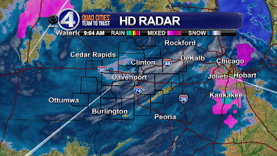
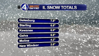
Good news for a change from the weather center here at CBS4 - the Winter Storm Warning has been canceled early and we're looking at mainly light snow through Wednesday afternoon. We'll see off and on snow showers with an additional inch of accumulation! Here are some of the totals from some of our Illinois towns so far, with the next official report from Moline due in at midnight.
And here's a link to a preliminary report from the NWS Tuesday evening.
Click Here

And here's a link to a preliminary report from the NWS Tuesday evening.
Click Here
Friday, February 22, 2013
Storm Winding Down - SNOW TOTALS
Well it wasn't the biggest snowstorm of the season, but some places definitely picked up a healthy dose of snow! In the QC the official totals are Moline with 2.8" and Davenport with 3.2". Some places ended up with half a foot of snow, including Iowa City, Burlington and Fairfield. In Illinois Macomb topped out at 5.0". Here's a map from the NWS with totals as of 9am

And a link here to the NWS summary page of our winter storm!
Click Here

And a link here to the NWS summary page of our winter storm!
Click Here
Thursday, February 21, 2013
The Fun of Forecasting Snow
UPDATED SNOW TOTALS - The official totals for the Quad cities are: Moline - 2.8" and Davenport -3.2"
Previous post -
Tonight's storm has been showing up consistently for some time now in the forecast models...and they've been consistently suggesting about 4-8 inches of snow...and while the storm would be fading as it closed in on the QC things still looked pretty safe for 4-6" of snow. The NWS sends out the Winter Storm Watch days in advance, then upgrades to a Winter Weather Advisory/Winter Storm Warning a day before and everything's all good, right? Then the day of the storm arrives and things look good on the radar and the snow's piling up, as expected in the Plains...
Then, dry air creeps into the storm from the South, winds out of the East eat away at some of the first flakes to fall...and all of a sudden what looked like a sure thing now looks questionable! The first wave of snow is about to roll into the Quad Cities and this will go a long ways in determining how much snow we pick up tonight. This first wave needs to drop at least 2 inches or so if we're going to meet the 4-6" forecast, otherwise totals will be a meager 2-4" and that won't be fun, at all!
Wednesday, February 20, 2013
Snow On the Way! (Winter Weather Advisory)
After a meager snow season so far we'll certaily add to our snow totals Thursday night and early Friday in the Quad Cities! The storm that's set to affect the Quad Cities has been showing up consistently in the weather models for the last week or so! Now that the storm is getting closer it's nice to see most models converging on a solution that means 4-6" for the Quad Cities.

And here's the official forecast from Ten at 10 on Wednesday night!


And here's the official forecast from Ten at 10 on Wednesday night!

Monday, February 18, 2013
Cooler Temperatures For Tuesday
 |
| Forecasted temperatures starting at 5 PM CST on Monday Feb. 18th |
Tuesday, February 12, 2013
Adding Daylight Every Day!
Our days are getting longer and longer now as we get deeper into the month of February! Technically the days started getting longer back in December, right after the winter solstice. Back then it was hardly noticeable but now we're adding minutes of daylight each day! This trend continues until late June when the summer solstice arrives, marking the longest day of the year in the Northern Hemisphere.
Day Sunrise Sunset
Mon 7:02 5:31
Tue 7:01 5:32
Wed 6:59 5:34

Day Sunrise Sunset
Mon 7:02 5:31
Tue 7:01 5:32
Wed 6:59 5:34
NASA Breaks World Record!

Guinness World Records confirmed that Landsat 5 holds the record for "Longest operating Earth observation satellite" with 28 years and 10 months of active use. The satellite had its share of issues throughout it's life, with 20 technical faults and it even lost the ability to store data on-board. Through these issues Landsat 5 still transmitted useable data for almost 30 years.
Landsat 5 was decommissioned on December 21st, 2012, 2 of the three gyroscopes stopped working and when the backup failed too, NASA pulled the plug. Landsat 5 made 150,000 orbits, and transmitted 2.5 million pictures back to Earth. It even outlived its replacement Landsat 6, now NASA relies on Landsat 7 for its Earth imagery.
Monday, February 11, 2013
How Windy Was It?
Now that the winds are finally fading we can take stock on just how windy it was across the area from Sunday afternoon through Monday afternoon! Basically the entire area was under a WIND ADVISORY for almost 24 hours! Look at some of the top gusts!

Here's a link to a more complete list comiled by the local NWS office Click Here

Here's a link to a more complete list comiled by the local NWS office Click Here
Not Quite as Windy Tonight
Even though it's still pretty windy outside the WIND ADV just expired for the Quad Cities at 3pm. Tonight will be breezy, but instead of winds at 30-35 mph with gusts to 50 mph we're looking at winds between 10-20 mph with gusts to 30 mph! One thing that will be nice this week - sunshine highlights the forecast through Wednesday!
Here's a Special Weather Statement just issued by the local NWS:
WINDS OF 20 TO 30 MPH WITH GUSTS TO 35 MPH WILL BE SEEN ACROSS THE
AREA THROUGH LATE AFTERNOON. THE WINDS ARE EXPECTED TO SLOWLY
DIMINISH THE REMAINDER OF THE AFTERNOON WITH A LARGER DECREASE IN
WINDS WITH SUNSET.
 |
| 3pm Winds |
Here's a Special Weather Statement just issued by the local NWS:
WINDS OF 20 TO 30 MPH WITH GUSTS TO 35 MPH WILL BE SEEN ACROSS THE
AREA THROUGH LATE AFTERNOON. THE WINDS ARE EXPECTED TO SLOWLY
DIMINISH THE REMAINDER OF THE AFTERNOON WITH A LARGER DECREASE IN
WINDS WITH SUNSET.
Sunday, February 10, 2013
A Rainy, Warm February Sunday in the QC!


Saturday, February 9, 2013
2-3 FEET of Snow in the Northeast!
 |
| Worcester, MA |
 |
| Long Island, NY |
 |
| Auburn, MA |
Thursday, February 7, 2013
Record Rain in the Quad Cities
Our steady, light to moderate rain has really added up over the last several hours...and we've broken the record for rain on February 7th in the Quad Cities! As of 6pm our total is up to 0.75" which is almost 0.20" more than the previous record.
Friday and Saturday look nicer, with plenty of sunshine and above average highs. Another chance for rain rolls in Sunday...

Friday and Saturday look nicer, with plenty of sunshine and above average highs. Another chance for rain rolls in Sunday...

Light Rain Falling This Morning

Monday, February 4, 2013
Quiet Week of Weather
After some recent snow, winds and cold temps our relatively quiet weather over the next few days will suit most people just fine I imagine! Temperatures will be a little above normal, with highs in the middle 30s for most of the week...and while there's a slim chance for flurries on Tuesday, and a light mix of rain/snow coming Thursday there are no big snowstorms in the immediate QC future! Proof of that here on a snow forecast from several models...

Andy

Andy
Subscribe to:
Posts (Atom)