Unfortunately, the news is not so great on area rivers as they continue to rise. The Mississippi River at Rock Island was at 18.94 feet at 6:00 Saturday evening. The river is expected to crest about a foot higher than that at 19.80 feet, and that is expected to occur around 7:00 Monday morning. If this crest holds true, it will be the 7th highest level ever! Below is the National Weather Service's hydrograph depicting the river's activity through next week. You can see that the Mississippi River is expected to be in the major flood criteria (in the magenta color) through Wednesday night and Thursday Morning.
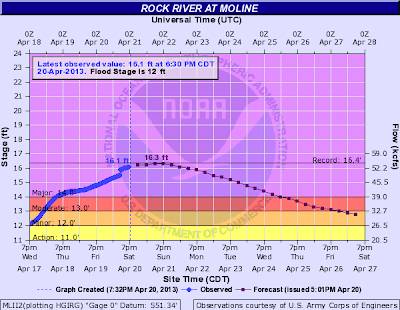
At 6:30 Saturday evening, the Rock River at Moline was at 16.10 feet and is expected to crest near an all time record level. The highest crest ever for the Rock River at Moline is 16.38 feet, which was set back on March 6th, 2008. For this event, the river is expected to crest at 16.30 feet around 1:00 Sunday afternoon. Here is the Rock River hydrograph from the National Weather Service. Like the Mississippi River, major flooding is expected through Wednesday night or Thursday morning.


No comments:
Post a Comment