Friday, January 31, 2014

Saturday Snow in the Quad Cities - Winter Storm Warning

9:30 pm Update:

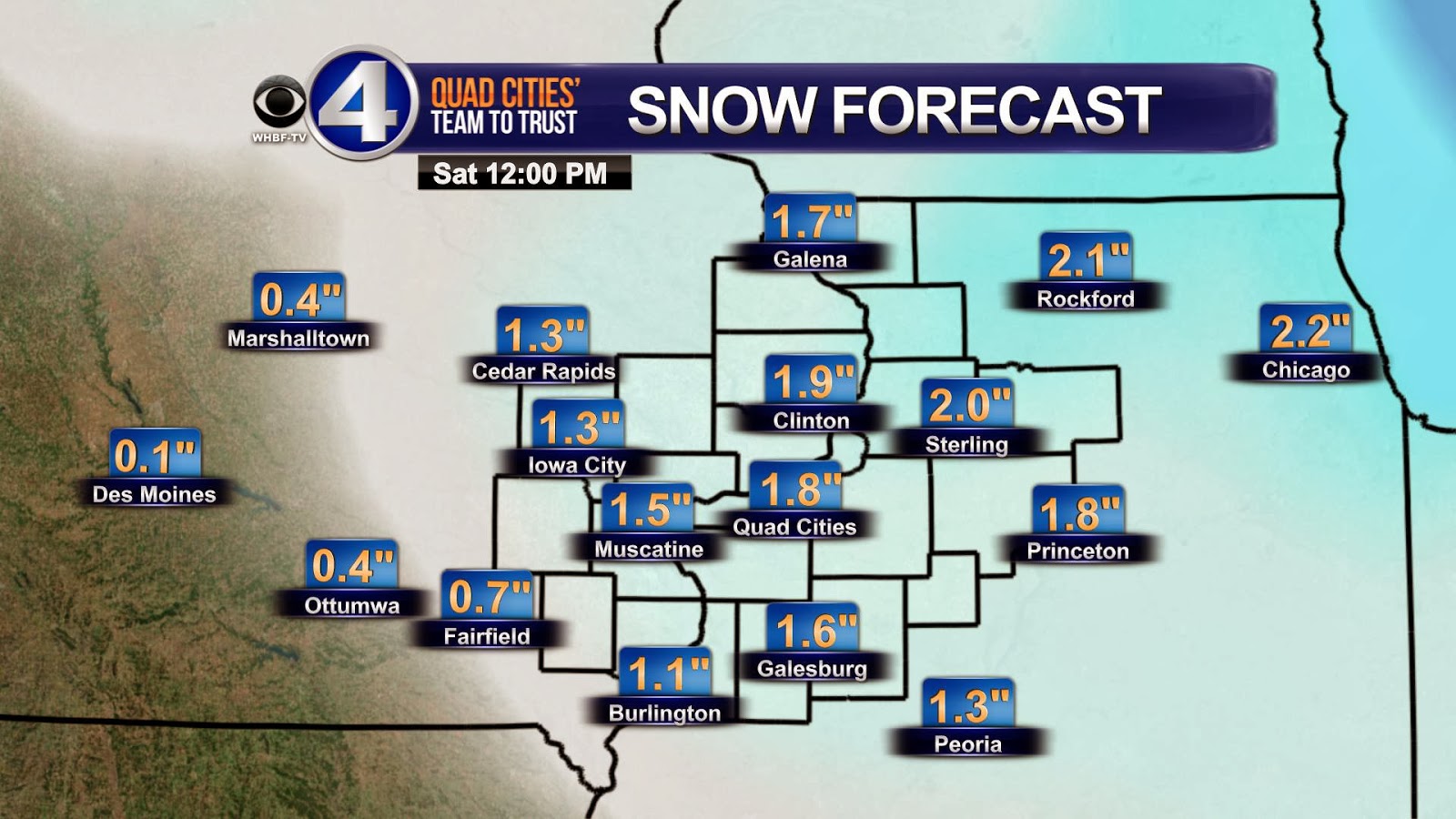
After looking at tonight's data I'm lowering the snow forecast for the Quad Cities slightly.  Quite honestly I don't like to change the forecast right before a storm arrives but I can't just ignore what I've seen so far this evening.  It will still be a decent snow in the metro area, but instead of 5-7 inches it's now looking more like 4-6".  Heavier totals are still on for areas South of the Quad cities, where there's already been 2 or 3 inches of snow today.  As of right now the Winter Storm Warning continues until 6pm Saturday...


Previous Post:
As expected meteorologists at the Quad Cities National Weather Service office upgraded the Winter Storm Watch to a Winter Storm Warning for parts of the area, including the Quad Cities.  Counties North of the Quad Cities are under a Winter Weather Advisory. 

Warning/Advisory
Things will go downhill quickly after midnight as snow starts up and becomes heavy at times.  Winds won't be terribly strong while it's snowing but could gust up to about 25 mph later Saturday evening as temperatures fall to near 0° by Sunday morning.

Now for the all-important question - how much snow?  In the Quad Cities everything is coming together for a total of 5-7" and there could be some higher amounts just down to the SE.  Conversely, slightly lower totals are likely NW of the metro area...

CBS4 Forecast

Model Forecast

Travel Impacts

Winter Storm Kicks Off The Weekend

Here is the latest on the winter storm on the way today, tonight, and tomorrow.

Light snow will spread across Iowa and Illinois today from south to north.  The snow will become heavier by daybreak Saturday through the midday hours.  It will end by late afternoon.


A "Winter Weather Advisory" goes into effect this evening through Saturday evening for the counties in the lighter shading of blue and a "Winter Storm Watch" for the blue-shaded counties.

Based on the data from early this morning, here is how much snow I'm expecting through Saturday.


Remember when you see a range, it could end up being on the low side or the high side.  Some automatically just think it'll be the high end of the range.

There are some indications the storm will track a little more to the north.  If that happens, warmer air could be drawn into the system and might cut back on the 7-9" of snow in our southern and eastern hometowns with some sleet mixing in.

Also, that would take the heavier snows more to the northwest.

The bottom line is that we're going to see a moderate to heavy snow event later today into Saturday.  Keep up on the latest forecast for any changes in the snow amounts.

Chief Meteorologist Andy McCray will have the latest this afternoon and tonight.

CBS4 Meteorologist Anthony Peoples


Thursday, January 30, 2014

Winter Storm Watch

10pm Update:  Most of the evening model runs are now in and I see no reason to change the forecast tonight.  We're still looking at a very good chance for accumulating snow late Friday night and Saturday.  the Winter Storm Watch is unchanged from the NWS...check out today's earlier post for details!  And remember, Anthony Peoples will have an important update Friday morning on CBS4 News This Morning!

Previous Post:

With more snow on the way, as Anthony blogged about earlier today the NWS has issued a Winter Storm Watch for the CBS4 area Friday night and Saturday.

Winter Storm Watch
It looks like snow will be the biggest problem with this storm, as winds shouldn't be too bad.  While there could be some freezing rain/sleet mixing in for portions of Central Illinois it should be mostly snow around the Quad Cities.  About the snow - there could be quite a bit of snow, especially SE of the Quad Cities.  Some towns like Galesburg, Kewanee and Princeton could end up with 6" or more!

Model output
Model output

And now my official forecast that you'll see on CBS4 News at 5 and 6 Thursday evening...


Snow and More Snow

This is already one of the ten snowiest Januarys on record in the Quad Cities and we have three more waves of snow on the way.

The first will arrive today and this is what it looked like on radar this morning.


Accumulations today will generally be an inch or less from the Quad Cities southward.  To the north of the metro area, an inch or two may fall.

We get a break tonight from the snow, but more arrives Friday.  The heaviest snow comes in Friday night and Saturday.

Here is how much snow could fall Friday and Saturday.


This does not include what may accumulate today.

Andy will have another update on the snow this evening on CBS4 News at 5, 6, and 10, and I'll be back Friday morning from 5-7 a.m. on "CBS4 News This Morning" with latest.  And, Kyle will be in the weather center this weekend with the snow totals and details on a potential snowstorm early next week.

CBS4 Meteorologist Anthony Peoples

Wednesday, January 29, 2014

More Light Snow

It's not a huge impact storm but light snow is looking likely for parts of the area on Thursday...especially North of the Quad Cities.  In the metro area we're looking at a dusting up to about 1" with up to 2" possible around Galena, Maquoketa and North of Sterling.

Timing - the best chance for snow in the Quad cities is from late morning through early afternoon...

CBS4 Snow Forecast
Saturday offers another chance for snow, and a chance for heavier accumulations!  A storm will be forming South of the Quad Cities this weekend and it looks like it will dump some heavier snows to areas South of the Quad Cities and possibly into portions of the metro area.  Check out this plot of some of the American weather models snow forecast for the next 7 days.  Notice the little spikes early on, with the possibility of heavier snow this weekend! 

If you're new to the weather model game remember the time translation, 18z Thursday translates to Noon Thursday in the Quad Cities...


Model forecast next 7 days
 

Tuesday, January 28, 2014

10-Day Forecast

Overall things are looking a little better over the next 7 days in the Quad Cities as far as the temps go!  We'll see a few days that are close to normal - the average high right now is 31 and the normal low is 14.  There are some snow chances coming up, including Thursday and late Friday/early Saturday.   First, check out this plot of temperatures through the next 7 days...

Check out the tail end of the 10-day forecast, it will get colder again by the middle of next week. 


 This final image shows some weather data and the departure from average for temperatures by the middle of next week, notice some colder weather creeping back down toward the Quad Cities! 

Another Below Zero Low Temperature

January temperatures in the Quad Cities are running 7.3° below average.


Here are the morning lows from Tuesday morning.

That -13° at Quad City International Airport in Moline, Illinois, marks the 20th below zero low temperature this winter.

Eight of those took place in December and twelve are from January.

The coldest temperature this winter in Moline has been -15°.

CBS4 Meteorologist Anthony Peoples

Monday, January 27, 2014

Another COLD Night

Some seasons the "coldest night of the season" might not be that big of a deal...this would not be one of those seasons!  We've already seen plenty of very cold weather this season in the Quad Cities.  11 of 27 January days have had below 0° temps and we had 8 days in December with below zero temps. 

Tonight we could see the coldest temperature of the season so far!  Here are the 6 (actually 7 because of a tie) coldest temperatures in what has been an extremely cold winter so far...Tonight I'm calling for a low of -16 in the Quad Cities! 


Record Setting Snow For January

The bitter cold is settling in for the next 36-48 hours across Iowa and Illinois after an Arctic front dropped through Sunday evening bringing some snow with it.

Officially, a combined total of 1.5" of snow fell in the Quad Cities from Friday and Sunday.  More may have fallen, but the winds made measuring it difficult.


That snow brings our January snow total to 17.4", which makes this our eighth snowiest January on record in the Quad Cities.

For the winter, we're now up to 32.2", which is now ahead of what we typically see for an entire winter (31.6").

More light snow is expected Thursday and we could see some more Friday night and Saturday.

CBS4 Meteorologist Anthony Peoples

Sunday, January 26, 2014

Blizzard Condtions, Then Dangerous Cold

The Winter of 2013-2014 is holding its own here in the Quad Cities.  An arctic front plowed through the area, dropping a quick half inch to inch of snow Sunday evening.  Combine that with very gusty northwest winds ushering in very cold temperatures, whiteout conditions have been reported across the area.  A Blizzard Warning goes until 3AM for the Quad Cities and points north.  It's important to note that a "Blizzard" does not necessarily mean heavy snow.  In fact, the snow is over.  A blizzard occurs with winds of 35mph+, with blowing (or falling) snow creating visibilities of 1/4 mile or less for 3 or more hours.

We'll start the work week with a continued chance for blowing snow, but the bigger story will be the dangerously cold temperatures.  Wind Chill Warnings and Advisories go into effect Sunday night and last through noon Tuesday.
"Wind Chill Warning" indicates wind chills could drop to -30° or colder for a significant period of time.  "Wind Chill Advisory" indicates wind chills could drop between -20° and -29° for a significant period of time.

Air temperatures Sunday night will drop between -5° and -15°.  Combined with strong northwest winds between 20 and 30 mph (gusts up to 40+mph at times), wind chills will be -20° to -40°!  Highs Monday will not make it above zero.  Temperatures won't go above zero until Tuesday afternoon for the southern half of the area.  Hometowns north of I-80 may not see positive temperatures until Wednesday!

This is dangerously cold weather, similar to the beginning of January.  Frost bite can occur to skin exposed to the cold in as little as 10 minutes to a half hour.  Keep an eye on your pets, young children, the elderly and of course, yourself.

Here's the Wind Chill Chart from the National Weather Service:


Saturday, January 25, 2014

Snow, Wind & Cold

Saturday featured mostly sunny skies, with falling temperatures and windy conditions.  A peak gust of 48mph at the Quad Cities International Airport Saturday morning.

After a sunny day, our attention focuses to the brutal winter weather headed our way.  Tonight, a "Winter Weather Advisory" goes into effect for counties along and north of I-80:
 Latest radar trends show the clipper tracking just a little farther north than anticipated, so in the Quad Cities expect 1-3" of snow, with just a little more northeast where the heavier snow will fall, and much less in our southwest hometowns.  Up to an inch in southern hometowns as the arctic cold front rolls through Sunday afternoon.

 Sunday evening a "Winter Storm Warning" goes into effect at 6pm.  This is NOT for additional snowfall, but for the strong northwest winds that will blow the fresh snowfall around, reducing visibilities.  This will cause treacherous driving conditions tomorrow afternoon and especially overnight.  Please be careful when driving.  Southern hometowns may be removed from the watch if very little snow falls (see above snow forecast).
After that, VERY COLD temperatures, possibly colder than earlier this month, are likely.  We'll see a high in the lower 30s Sunday afternoon and will drop between -10° and -15° Sunday night and Monday morning.  Wind Chills could be as cold as -25° to -35°!  Wind Chill Warnings are in effect for Knox, Stark and Lee counties in Illinois beginning Sunday night, and a Wind Chill Advisory goes in effect for Henry and Jefferson counties in Iowa Sunday evening at 6pm.

Stay tuned for more updates!

Friday, January 24, 2014

Wintry Weekend Update


There's been no shortage of wintry weather so far this month and this weekend looks REALLY BAD TOO!  We'll see a few rounds of snow, strong winds and life-threatening cold temps/wind chills late this weekend and early next week.

Friday night offers a good chance for light snow between 7pm and a little after midnight.  In the Quad Cities 1-2" is likely.  After a quiet start Saturday morning the winds pick back up Saturday afternoon and temps fall back to around 10 degrees late in the evening. 

Saturday night offers another good chance for snow.  With this system 2 inches of additional snow is a good possibility and some locations cold see more like 3 or 4 inches of fresh snow.  Most of this round of snow will wrap up by early Sunday morning. 


Then the arctic front arrives Sunday late afternoon/evening.  This front will produce snow showers, but the biggest impact by far from this front will be the temps/wind chills that drop like a rock Sunday night.  By Monday morning wind chills will be as low as 40 below and things will stay EXTREMELY cold through Tuesday night!  This Winter Storm Watch is in effect for the combination of blowing snow and dangerous wind chills! 


Two Snow Events This Weekend

It's been two days since we picked up measurable snow in the Quad Cities (0.2" on Wednesday).  With the active northwesterly flow aloft and clipper systems dropping in out of Canada every couple of days, we're in for more snow this weekend.

The first of two systems that will bring snow will arrive this evening and tonight.  Here's how much snow is expected by daybreak Saturday.


We get a break from the snow Saturday with some sunshine, a lot of wind, and falling temperatures.  By Saturday afternoon, clouds start increasing with the next system.

Snow is likely Saturday night and Sunday.  We could have around 3" of snow on the ground by 6 a.m. Sunday.  (This DOES include the snow we're expecting tonight).


When the snow is over Sunday, most of the area will have picked up 2-5" of new snow from the two systems. 

Much colder air comes in for early next week.

CBS4 Meteorologist Anthony Peoples

Thursday, January 23, 2014

Wind Chill Advisory Tonight

Here's a quick look at some of the worst wind chills from early Thursday...when several locations dipped to -30 and colder!


And tonight it's a Wind Chill Advisory for the Quad Cities.  That means wind chills be as low as -25 for portions of the area tonight.  The good news - temps bottom out late this evening and then actually go up a bit after midnight.  While there could be some delays Friday morning I do not expect widespread school closings on Friday! 

More Below Zero Cold

January temperatures are running more than 6° below average and this comes after December ended up being 6° below average.


Here are the morning lows, so far, Thursday.

That -7° low in the Quad Cities marks the 17th time this winter we've dropped below zero.  Eight of those were in December and we've had nine in January.

While I expect rising temperatures overnight tonight, it's likely that we'll still be below zero at midnight and that would add another below zero low to the count.


And, after a couple of snow events this weekend, more subzero temperatures are expected Sunday night through Tuesday night.

CBS4 Meteorologist Anthony Peoples

Wednesday, January 22, 2014

Dangerous Wind Chills Tonight

9pm Update:  As temps continue to plummet tonight the NWS has upgraded another row of counties from the advisory to a Wind Chill Warning.  The warning now includes the Quad Cities metro area and tonight's weather threat should not be taken lightly!

Updates warning product
Previous Post:
The beat goes on - another Wind Chill Advisory for the Quad Cities tonight and it'll be even worse North of the metro area!  A Wind Chill WARNING is in effect for several local counties also.  Temperatures will dip down below zero tonight, and wind chills will be as low as -30 in the metro area and could be close to -40 North of the Quad Cities.  With wind chills like this frostbite can occur in as few as 10 minutes. 

On nights like this it's best to stay inside with the heat cranked up, and if you do have to head out make sure your cell phone is charged in case of emergency.  Also, toss an extra blanket or 2 in the car and an old pair of gloves just in case your car fails you at the worst time!


Also, with winds picking up and some more light snow falling this evening visibility will be down at times.  Here's a shot from our Skycam late this afternoon...


CBS4 Skycam at 4:30 pm


Tuesday, January 21, 2014

January Snow Nearing The Record Book

Several disturbances will be moving across the Mississippi and Illinois Valleys through early next week.  Each will bring the threat of snow and a reinforcing shot of cold air.

The first will arrive late tonight and Wednesday, but accumulations will be on the light side.

A stronger system will likely bring a few inches of snow Friday night and Saturday. 


Another could be coming in Sunday night and Monday.

Officially, at Quad City International Airport, in Moline, Illinois, 2.1" of snow fell Monday night.  That brings our January 2013 total to 15.7", just one inch shy of this being one of the ten snowiest Januarys on record.

As for the winter of 2013-2014, we're up to 30.5".  In an average winter, we see 31.6" of snow.  We're still a little over a foot of snow away from this winter cracking the Top 25 list of snowiest winters!


Along with the snow, we have the cold!  Temperatures for the rest of January into the first part of February will remain below average, so there is no relief is in sight!

CBS4 Meteorologist Anthony Peoples

Monday, January 20, 2014

Wintry Weather Update - Light Snow and Wind Chill Advisory Details

After a couple of relatively nice weather days in the Quad Cities winter makes a return starting this evening.  We'll see light snow for a few hours late this evening, with totals ending up pretty close to 1-2" in most spots.

And the super cold weather makes a return tonight also.  Temperatures will be below zero by a few degrees, and wind chills will be as low as -25!  That means a Wind Chill Advisory is in effect and frostbite can occur in as little as half an hour.  Bundle up and cover as much skin as possible if/when you head out late tonight and early Tuesday.

Wind Chill Advisory

Wind Chill Effects


Wind Chill Chart

Snow This Afternoon & Tonight

The warm day Sunday melted away some of our snow, but more is on the way later today and tonight.

The heaviest snow will be around the Quad Cities and to the south.


So far, this winter in the Quad Cities, we're already up to 28.4″ of snow, which is only 3.2" shy of the average winter snowfall.

January is running 7.8" above average for this point in the month for snow.

CBS4 Meteorologist Anthony Peoples

Sunday, January 19, 2014

More Cold Temperatures in the Forecast

It was unseasonably warm day across parts of the area Sunday.  Hometowns northeast of the Quad Cities with a little more snow on the ground saw just a little bit cooler temperatures than the rest of us.
Early on Martin Luther King Jr. Day we will have a cold front move through the area that is going to cool things off through the afternoon hours.  In fact, we go below zero by Tuesday morning, and could be below a few times during the work week.

It's already been a below average (Meteorological) winter.  Here's a graphic showing the average temperature from Dec. 1st through Jan. 18th compared to the normal  average temperature, and how many nights we've been below zero.

Saturday, January 18, 2014

Saturday Snow Summary

The clipper system responsible for our snow Saturday has come and gone, and has dropped some decent snowfall amounts.  The center of low pressure tracked just to the west of the Quad Cities, leaving the heaviest snow to the northeast of the low on the Illinois side of the Mississippi River.

 While many of our Iowa hometowns did see snow showers, amounts weren't as hefty.
So, where do we stand here in the Quad Cities as far as snowfall goes?  Here's the latest stats at the Quad City International Airport through January 18th:
The National Weather Service in Davenport has put together a full list of snowfall reports, and you can take a look by clicking HERE.

Looking ahead to the week, no big snows expected.  A couple systems could bring light snow on Monday and Wednesday, and possibly Saturday.  The bigger story will be the return of the COLD!