 |
| Barometer from Delaware (11:00 p.m.EST on 10/29/12) |

Wednesday, October 31, 2012
Low Pressures Within Sandy
Tuesday, October 30, 2012
October Lunar Halo
Anybody see the nice lunar halo around the moon on Monday night? It was a sight to see! It happens when you have cirrus (high) clouds in the place and is a result of the moonlight reflecting/refracting off the ice crystals from the cloud...sometimes tough to get a good picture of, here's a shot from the Quad Cities late Monday night.


Time Lapse of Hurricane Sandy hitting New York City
I first saw this video on the WREX Weather Blog out of Rockford...and kudos to whoever made the video!
Monday, October 29, 2012
Latest on Sandy
Here's the latest Sandy SAT/RAD picture as of Monday evening...the storm packs winds of 90 mph and is now moving WNW at 28 mph. For the latest advisories from the National Hurricane Center Click Here
 Thoughts and prayers to all those affected along the East Coast, it could be a very long 48-72 hours...and even longer with no electricity.

Impacts from Sandy
 |
| Residents in Rehoboth Beach, DE watching the high surf. (Courtesy of Carolyn Patton) |
Sunday, October 28, 2012
Sandy's Impact....

Here is a map of most weather advisories,
watches, and warnings that have been issued due to Sandy! Everything from
Hurricane Warnings, to High Wind Warnings, Flood Advisories, and even Blizzard
Warnings! IMPRESSIVE to say the least! Even Chicago is under a High Wind Watch
because of Sandy!
Sandy & the Heavy Rainfall Threat....
As of Sunday afternoon, Sandy was still a category one hurricane with winds of 75 mph. Even though Sandy is only a category one, she is still a very powerful storm due to simply her SIZE! Below are rainfall forecasts for the Northeast and Mid-Atlantic. Some areas could pick up close if not more than 10 inches of rain when all is said and done!

Sandy is now forecasted to be a hurricane through late Monday. Latest model forecasts have Sandy making landfall late Monday night into early Tuesday. That's when she will make landfall over Delaware and New Jersey.

Sandy is now forecasted to be a hurricane through late Monday. Latest model forecasts have Sandy making landfall late Monday night into early Tuesday. That's when she will make landfall over Delaware and New Jersey.

Saturday, October 27, 2012
Watching Sandy's Forecasted Path...
Sandy will keep an area of high pressure from moving out of our region
over the next several days here in the Quad Cities. But, for the East Coast, Sandy means heavy rain, damaging
winds, flooding, and heavy snow.

Right now, forecasters are expecting Sandy to go from a Hurricane into an extratropical system by the end of the weekend.
Stormcast is forecasting Sandy to make landfall as an extratropical system sometime on Monday over the Mid-Atlantic states. We'll keep you posted.
Friday, October 26, 2012
With Sandy in Mind, National Weather Service Launching Extra Weather Balloons
With the threat of a catastrophically huge storm looming (Sandy) the
National Weather Service is doing all it can to come up with the most
accurate forecast possible, including launching extra weather balloons
through the lower 48 states. The Quad Cities local office is now
launching 4 weather balloons per day instead of the normal 2. These
instruments collect data such as temperature, humidity, wind speed etc
all the way up to about 90,000 feet in the atmosphere! The data
collected is sent by a radio signal back to the office, and eventually
ends up being digested and used in many ways to help with the forecast.
In the QC, meteorologists will be sending up the extra balloons through Monday morning while folks in the East and South will continue the extra balloons through Tuesday, when Sandy is expected to make landfall somewhere along the East Coast! Here are some pics from today's launch around lunchtime!


See the doppler radar in this shot!
Thursday, October 25, 2012
1 Hour Temperature Drop
It was pretty easy to tell when the cold front slammed through the area earlier today...whether it was from 12 to 1pm or 1 to 2pm temperatures crashed all across the area today! In the QC we saw 19° drop from 1 to 2pm as the temp fell from 72° to 53°! Since then the temps have fallen even further, back into the lower 40s so far! Here's a list of 1 hour temp drops from the NWS in Davenport...Click Here


Wednesday, October 24, 2012
Close to a Record High!

Tuesday, October 23, 2012
Record Highs on Wednesday?

Oh Sandy

Early Showers..

Monday, October 22, 2012
Monday Rains

Sunday, October 21, 2012
Temperatures Rise then Plunge......
Thursday, October 18, 2012
National Weather Service Winter Outlook....


Wednesday, October 17, 2012
2012: Warmest September on Record!

The united states overall did not have a record setting warm Sept, as we only had the 23rd warmest Sept. on record. Sea surface temperatures played a major role as a weak El Nino conditions are developing. Though it doesn't look likely, if El Nino were to occur, we would continue with a warmer fall and winter season.
Tuesday, October 16, 2012
More Rain On The Way....

As of Tuesday afternoon, we're thinking the Quad Cities will pick up about a quarter of an inch of rain by Thursday. Some areas could pick up close to a half inch if a thunderstorm happens to move through. Either way we'll take more rain because we are still more than 9 inches below normal for the year.
So when exactly will the rain arrive? Well there's a small chance for rain during the morning hours. But, it's between the lunch time hour through the drive home from work when we'll see the most rainfall around the QCA. So grab the umbrella before you leave home Wednesday morning for work!

Monday, October 15, 2012
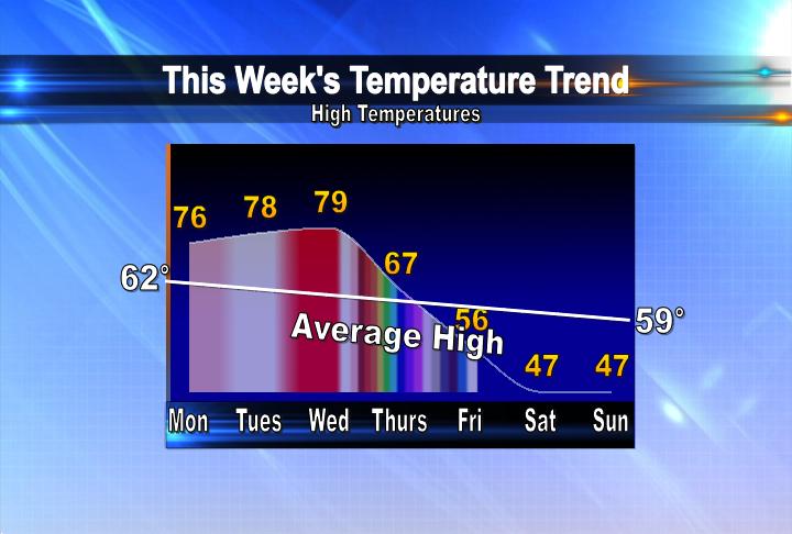
Above Average Temps for Tuesday...
A strong southerly wind from 10-20 mph with higher gusts will boost our high temperatures into the 70s. Eventually, on Wednesday, a cold front will cause our temps to tumble into the 50s for highs by week's end.
Sunday, October 14, 2012
Saturday & Sunday Rainfall Totals...

Fairfield fell shy of 3 inches while Iowa City came in just short of 2 inches. All neighborhoods picked up more than an inch of rain. More rain is on the way by the middle of the week. We'll keep you posted!
Strong cold front pushes through the QCA....


Saturday, October 13, 2012
Saturday Rainfall Totals as of 9pm....
Some much needed rain fell in the Quad Cities on Saturday. So far the Quad Cities has picked up 0.81" of rain. That brings our total for October to 1.06" More rain is on the way late Saturday night and for your Sunday. Some of the rain could be on the heavy side and some neighborhoods could pick up 2-3" of rain when all is said and done by Sunday evening.

Friday, October 12, 2012
Heavy Rain On The Way?

Thursday, October 11, 2012
Severe Weather Update
One day closer and we're still on track for showers, t-storms and perhaps some severe t-storms on Saturday. A big fall storm will be developing and moving through the middle part of the country. Late Friday night we could see a few thunderstorms but the best chance for SEVERE T-STORMS will be Saturday evening. Here's an updated graphic from the Storm Prediction Center showing the risk for svr weather on Saturday. If we see strong to severe t-storms the biggest threats most likely would be:
1. Damaging winds
2. Heavy rain
3. Isolated tornadoes

1. Damaging winds
2. Heavy rain
3. Isolated tornadoes

Wednesday, October 10, 2012
National Weather Service Survey
From time to time the National Weather Service, part of the Dept of Commerce, looks for input on how they can better serve the needs of the US public...and you can help them out by filling out their survey! Here's a link to the survey on their website... Click Here


Wow, Wind Chills!

Tuesday, October 9, 2012
Severe Weather this Weekend?
It's only Tuesday, but we're already checking things out for this
weekend in the Midwest. Severe t-storms will be possible Saturday for
portions of Illinois, Iowa, Wisconsin and Minnesota among other states! An
upper level low will be moving slowly into the area, combined with a
strong surface low forming some of the ingredients look to be in
place. This is still several days away but it'd be a good idea to check
back a little later in the week...and of course we'll keep you updated
on CBS4 News all week long! Here's an outlook from the NWS SPC
highlighting the risk for certain areas on Saturday!

To read more from the Storm Prediction Center Click Here!

To read more from the Storm Prediction Center Click Here!
Monday, October 8, 2012
Can You See the Northern Lights?
After a recent (last Thursday) explosion on the sun some people are seeing the Northern Lights tonight! Chances are the great display will stay just North of the Quad Cities but with clear skies maybe we'll catch a glimpse! Here's an updated Aurora forecast from Monday evening...

And to read much more about it Click Here!

And to read much more about it Click Here!
Another Cool Morning in the QCA

Temperatures once again dropped into the lower 30s to begin Columbus Day in the Quad Cities. Every recording station stayed at or just above the 30° mark. These chilly lows will warm over the next few days and we will stay above freezing throughout the next 7 days. Keep the jacket handy as some afternoon highs in the upcoming days will only be in the mid 50s.
Sunday, October 7, 2012
More sights of Fall around the QCA....

Toni of Dixon, IL sent us these pictures of some beautiful fall leaves around his neighborhood this weekend.
If you have any fall pictures from your town feel free to send them to us through e-mail at weather@cbs4qc.com or search for us on Facebook: WHBF TV

Saturday, October 6, 2012
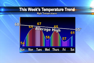
Temperatures on a Rollercoaster for the upcoming week....
Friday, October 5, 2012
Colder and Colder and Colder...

It just keeps getting colder in the Quad Cities! The big drop started yesterday and it continues as we kick off our weekend today. Temps have been in the 40s for most of the afternoon, when the normal high is 69°! Tonight, with some clearing, we'll see lows in the upper 20s and lower 30s and that's prompted the NWS to issue a FREEZE WARNING for all of the areas shaded in blue. The only reason a few counties to the North are not included is because those areas have already seen their growing season end, when the temp dropped into the upper 20s back in September!
What a difference a day makes.....

 A cold front moved through the QCA on Thursday and that system has caused a big drop in our temperatures!
This morning most neighborhoods started out 15 to even 25 degrees cooler.
Temperatures will stay well below average over the weekend as high temps only climb into the low to mid 50s! Stay warm and have a great weekend.
Thursday, October 4, 2012
Cold Front Moves Through...
The much advertised cold front has now pushed through the Quad Cities! Our temps earlier today were near 70° and now we're back into the 50s, with lows dipping into the upper 30s later tonight. The next few days will be much cooler than normal, with highs only in the 50s. As for the rain, we've seen scattered showers so far and from here on out most of the wet weather will be south of the Quad Cities!


Tuesday, October 2, 2012
Big Weather Changes Coming...

Blizzards to be named by TWC?

The Weather Channel says some major storms in the past have already received a few nicknames, such as snowmaggeddon, and it would be a bit easier to distinguish those storms if they had names. They already have a list of 26 names for potential winter storms, starting with Athena, Brutus, and Caesar. The names follow a Greek/Roman theme and there are no repeats of hurricane/tropical storm names.
The names will be issued to winter storms that will have a big impact on large areas of population and the storms will only be named 3 days prior to the expected impact. However The Weather Channel has not listed or described any criteria on how they will determine if it will be a major storm. The goal is to raise public awareness of the intensity of these big winter storms.
Monday, October 1, 2012
September Climate Numbers
September has come and gone, and it turned out to be another dry month! We started off with some rainy days at the beginning of the month but overall we only ended up with 2.19" of rain which is almost an inch below normal.
As far as the temperatures went - we actually ended up below normal for the first time in several months! The average temperature was 62.7° which is almost 3 degrees below normal!
For more climate info check out this page from our local office of the NWS! Quad Cities NWS Climate stats
As far as the temperatures went - we actually ended up below normal for the first time in several months! The average temperature was 62.7° which is almost 3 degrees below normal!
For more climate info check out this page from our local office of the NWS! Quad Cities NWS Climate stats
Subscribe to:
Posts (Atom)