Friday, September 30, 2011

A Surge of Warm Air Moves into the QC...

It's going to be a chilly weekend with temperatures about 10 degrees below average. However, on Monday temperatures will climb into the 70s and stay in the upper 70s for much of next week. So why are temps going to above normal for much of next week?

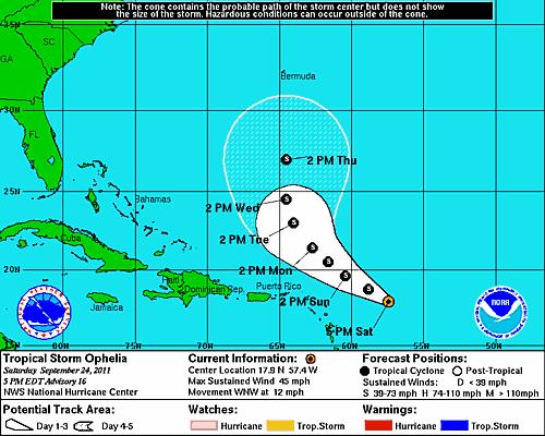
Well, next week there's going to be a trough in the jet stream (which is the upper-level winds in the atmosphere) in the Western U.S. and Eastern U.S. with a ridge located in the middle of the country. This is known as an omega block, because the winds take the shape of the greek letter, omega! An example of what the winds would look like according to the weather models in an omega block is shown below.


So this wind flow pattern means that warm air will flow into the Quad Cities from the South for much of next week until the winds in the upper-levels of the atmosphere shift.

Thursday, September 29, 2011

A Windy Thursday in the QC....


A cold front moved through the region early Thursday afternoon and that sparked some rain showers. However, the bigger weather story was the strong winds during the afternoon hours!

Check out some of the wind gusts record around 4 o'clock Thursday. Galena and Iowa City both had winds gusting close to 50 mph! While winds in the Quad Cities gusted upwards to 40 mph.

Wednesday, September 28, 2011

Strong Winds Coming Up!


Get ready for a breezy Thursday! We'll see winds picking up around lunchtime and there's a WIND ADVISORY from 1pm to 10pm Thursday! Sustained winds will peak between 25-30 mph and gusts will be as high as 45 mph!

Tuesday, September 27, 2011

More Rain!

We escaped most of the rain today in the Quad Cities but the wet weather is back tonight! Expect showers through midnight or so, and mostly dry weather (and some sunshine!) returns Wednesday...

Not Quite as Bad Today...

After a rainy, wet and windy Monday things are looking a little better today! There's still some cloud cover and a slight chance for more scattered showers but the visible satellite shows some clearing across parts of the area! There's more sunshine on the way later this week!

Hurricane Hilary moves away from Mexico.


Hurricane Hilary, a Category 3 storm on the Saffir-Simpson scale of hurricane strength, is still spinning off the west coast of Mexico, as seen by NASA's Terra satellite.

Hilary has winds of 120 mph (195 kph) and is moving toward the west, away from the Mexican mainland. At its strongest, Hilary achieved Category 4 status, with winds of 140 mph (220 kph).

Between today and early Wednesday, Hilary is expected to slow down and make a turn to the northwest as it weakens

Sunday, September 25, 2011

Several Waterspouts Over The Weekend...


There were several spottings of waterspouts over Lake Michigan near Milwaukee, WI on Saturday.

Waterspouts look similar to tornadoes. They are known as tornadoes that form over water, but they aren't as strong as regular tornadoes.

The waterspouts that developed on Saturday had winds of 40-60mph and they were short lived.

Waterspouts are common during this time of year because the waters in Lake Michigan are warmer than the air above the water's surface. So when there are thunderstorms and/or strong winds around the lake, the winds will pick up the water forming a funnel that leads to a waterspout.

Check out a time lapse of one of the waterspouts below:

Saturday, September 24, 2011

Some Activity in the Tropics....


Two tropical storms have developed in the Atlantic Ocean! Tropical Storm Ophelia and Tropical Storm Philippe are churning through the waters right now. Neither storm is projected to hit land.


As of 5pm Saturday evening, Ophelia has winds of 45 mph and the storm is moving to the West-Northwest at 12 mph. Ophelia is not forecasted to become a hurricane at this point.

However, Philippe will reach hurricane strength by Monday afternoon and the National Hurricane Center says it'll likely become a category two hurricane later in the week. Philippe has winds of 40 mph and is moving to the West-Northwest at 14 mph.

Friday, September 23, 2011

Quad Cities Marathon


Good luck to everyone running the Quad Cities Marathon on Sunday morning! It looks like temps start in the 40s and end up in the 50s for the race. There's a slight chance for a couple of sprinkles or light showers!

Thursday, September 22, 2011

Drought Continues...

Drought continues across parts of the Midwest, here's the link to read this week's local NWS report.http://www.crh.noaa.gov/dvn/?n=drought


Fall Begins Friday!


Fall officially begins early Friday morning at 4:05 am! At that brief moment the Earth's axis is not pointing toward the sun or away from the sun. The term "equinox" translates to "equal night." On this day everywhere on Earth will have 12 hours of daylight and 12 hours of darkness! However, if you look up the sunrise and sunset times for the QC on Friday you'll find the sunrise is at 6:50 am and the sunset is at 6:58 pm! One of the reasons for this is the fact that "sunrise" here in the Quad Cities is based on when you can see the tip of the sun coming up above the horizon (conversely "sunset" is when the full sun has gone down below the horizon.) It takes a few minutes for the sun to fully rise and fully set and this is the main reason the daylight doesn't add up exactly to 12 hours! For a little more feel free to check out this site:

http://www.timeanddate.com/calendar/september-equinox.html


They've got all you need to know about Friday's Autumnal equinox!

(Picture courtesy of website mentioned)

Wednesday, September 21, 2011

More Dry Weather and a Warm-up...


Some of the medium range forecasts are painting a mild and dry start to October in the Quad Cities...here are a couple products from the Climate Prediction Center. They show a good portion of the country enjoying fairly warm weather to start October! I'm sure it'll be a different story by the end of the month!

Tuesday, September 20, 2011

Fall Begins

We've had some fall-like weather lately in the Quad Cities and this Friday fall officially begins! The equinox is early Friday morning, and it'll feel like fall all day long! For the rest of the 7-day check us out on Ten at 10!

Monday, September 19, 2011

Clearing Out!


After some Monday morning clouds things have turned out pretty nice Monday afternoon! The visible satellite shows the cloud base is now well East of the QC and temps are around 70 for most of us, enjoy!

Sunday, September 18, 2011

Sunday Evening Rainfall Totals...


It was a soggy Sunday in the QC, but some much needed rain fell across the region. Here are the rainfall totals from Sunday's rain as of 7 o'clock Sunday night.

The next chance for rain arrives late Tuesday night into Wednesday, however, it's only a small chance because the cold front is rather weak!

The front will more than likely only cause our temperatures to drop below average by mid-week.

This Week's Temperature Trend...


It will feel rather nice when you step outside on Monday and Tuesday. Temperatures will be around our average high of 76° (average temps indicated by white line in the image) to begin the week.

Unfortunately, temperatures will quickly drop below average by Wednesday! It will be even cooler on Thursday as temps drop into the 60s for highs. However, temperatures will warm back up to where they should be by next weekend!

Saturday, September 17, 2011

A Rainy Sunday On Tap...

Several neighborhoods around the Quad Cities could sure use some rain! Officially, the QC has picked up 0.96" of rain for September, but we are 3.63" below where we should be for this time of year.

Fortunately, a low pressure system will move across the region Saturday night into Sunday providing us with a decent amount of rain.

Right now, a few forecasts are showing that some neighborhoods could pick up close to an inch of rain on Sunday especially for areas South of the QCA. So it looks like a good day to stay inside, read a book or watch some NFL football!

Checking The Tropics....


Things have calmed down in the Atlantic Ocean after several tropical storms developed a few weeks ago.

Right now, the National Hurricane Center is watching a weak storm system near the Cape Verde Islands (The area circled in yellow).

This disturbance only has a 20% chance of developing into a tropical system over the next 48 hours. It's moving to the West at 10-15 mph.

Thursday, September 15, 2011

October Outlook


The Climate Prediction Center has just come out with their temperature and precipitation outlook for the month of October. In the Quad Cities we could be looking at a warmer than average month, and unfortunately a month with below average rain, again!

Drought Status Update

The drought situation south of the QC got a little worse this week...as we haven't had much rain over the last several days, or through the month of Sept for that matter! Check out this link from our local office of the NWS for more...


http://www.crh.noaa.gov/dvn/?n=drought

Wednesday, September 14, 2011

A Cold Night Coming Up!

We could see some patchy frost in the Quad Cities late tonight and early Thursday...but it will be even colder just off to the North! In fact, Freeze Warnings and Frost Advisories are posted for large portions of Northern Iowa, Minnesota, Wisconsin and the Dakotas! It's a matter of time now before our temps drop off for good!

Tuesday, September 13, 2011

Another Scorcher in Dallas

Dallas hit 100° (actually 107°) again today. This in and of itself is not shocking news. What is crazy though is the fact that this is the 70th time this year they
have topped out at or above 100°! That sets a new record for number of times reaching 100° in "the Big D"


Click here for more: http://www.srh.noaa.gov/fwd/?n=danncon10

More Dry Weather...


While we ARE looking for some big weather changes this week (a significant temperature drop) in the Quad Cities - we DON'T expect a lot of rain over the next few days. We've had more than our fair share of dry weather lately, and other than a slight chance for a few sprinkles Wednesday the dry weather continues through early this weekend! By Sunday a decent chance for showers arrives...

Sunday, September 11, 2011

Temps Will Take A Dip This Week...

A major cool down is coming to the area later this week. In fact, the weather hasn't been this cool since early May. Temperatures on Monday will be in the upper 80s to near 90 degrees.

However, two weak cold fronts will pass through the area dropping our temperatures into the 70s and then the 60s by the end of the week. Temps will rebound into the 70s by next weekend!

Right now, our average high temperature in the Quad Cities is in the upper 70s. Have a great week!

Thursday, September 8, 2011

Tropical Storm Nate

Nate's getting stronger and stronger in the Southern Gulf of Mexico right now. The storm is barely moving right now and should strengthen into a hurricane this weekend. Models are having a tough time predicting where this storm will go.


Stay tuned on this one (notice the different spaghetti plots!)

Drought Continues...


Parts of the QCA are in a SEVERE DROUGHT! Here's an update that just came out today from the National Weather Service and its partners...Making matters worse is a lack of substantial rain in the next week's forecast! Click here to read more from the NWS: http://www.crh.noaa.gov/dvn/?n=drought

Wednesday, September 7, 2011

Busy Tropics...


There's a lot going on in the Atlantic basin right now, as we approach the peak of the 2011 hurricane season! Typically the peak is around Sept 10th or so, and it looks like we'll have a few things out there worth watching over the next few days! It still looks like Katia will be missing the East coast as it curves out to sea. However, Tropical Storm Nate has formed now and this storm could make landfall as a hurricane along Mexico's coast, or along the US coast sometime early next week!


Nate's path is uncertain right now!

Tuesday, September 6, 2011

Quad Cities Sunset


Here's a nice pic from our Skycam tonight! It's going to be another clear and cool night in the QCA!

Monday, September 5, 2011

A Very Cool Labor Day!


What a beautiful day in the Quad Cities! And what a perfect day to celebrate Labor Day! I'm sure lots of people are grilling out all across the QCA today with sunshine and highs in the upper 60s! This is the coolest Labor Day we've had since 1974 - when it topped at at a very chilly 57°!

Sunday, September 4, 2011

Keeping an Eye on the Tropics...


Tropical Storm Lee made landfall along the Gulf Coast over the weekend. Lee is dumping heavy rains over the same areas because the system is moving so slow.

As of Sunday night @ 9 pm, Lee was only moving to the North @ 5 mph. Late Sunday Evening Lee was downgraded to a Tropical Depression with winds of 35 mph.


However, more trouble is brewing in the Atlantic Ocean. This weekend Katia became a Hurricane and is forecasted to intensify into a major Hurricane by Wednesday with winds exceeding 110 mph.

Right now, it appears that it'll just graze the Eastern seaboard but it's way to early too be certain. We'll keep you updated throughout the week online and on-air!

Saturday, September 3, 2011

A Stormy, Soggy Saturday...


Despite it putting a damper on your Saturday plans, the rain that fell was desperately needed. Officially in the Quad Cities (As of 9pm), we picked up 0.82" of rain. However, Muscatine had over an inch of rain along with Iowa City.


The strongest storms moved through Fairfield, Burlington, and Galesburg Saturday afternoon. They also produced some strong winds and large hail.

In fact, a weather spotter reported hail the size of golf balls on Saturday afternoon in Fairfield, IA. There was one report of some wind damage in Abingdon, IL.

The rest of the holiday weekend will be quieter and drier with temperatures on the comfortable side!

Friday, September 2, 2011

Labor Day Weekend


Our Labor Day weekend is off to a hot start, and we'll see some rain over the next 24 hours...


But then we're looking just about perfect starting late Sat. night through Labor Day! Enjoy and be safe!

Updated Rain Forecast...


Here in the Quad Cities if we're lucky we'll see a nice soaking rain over the next 24 hours or so...as the HPC has us highlighted for about an inch of rain! Down to the South, along the Gulf Coast they're looking at more than a foot, and possibly 2 feet, of rain over the next 5 days! The tropical deepression I mentioned yesterday has now strengthened into Tropical Storm Lee! It's one to watch, not so much for strong winds as the heavy rain coming to Louisiana!

Thursday, September 1, 2011

Ridiculous Rain Amounts!

Here's a rainfall forecast for the country for the next 5 days. In the Quad Cities if everything works out we'll see up to about an inch of rain (let's hope we do.) Portions of Louisiana could see up to 20 inches of rain though (maybe more!) There's a slow-moving tropical depression down in the Gulf of Mexico that should become a tropical storm in the next 24 hours and as it drifts North it will drop flooding rains over some places that are very very dry right now. In all my years of looking at this forecast product I don't think I've ever seen this wet of a forecast!


Drought Worsens


The drought gripping parts of the Midwest (including portions of our area) is getting worse! Conditions are especially bad just South and SW of the Quad Cities. For an extensive report from the National Weather Service on the drought in our area check out this link:

http://www.crh.noaa.gov/dvn/?n=drought