Sunday, July 31, 2011

Sunday's Mississippi River Flood Update...


The flood warnings for Scott, Rock Island, Whiteside, and Clinton Counties was canceled by the National Weather Service early Sunday.

On Sunday, the Mississippi River dropped below flood stage in the Quad Cities.

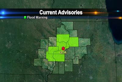
However, Flood Warnings are still in effect for Louisa, Des Moines, Henderson, and Mercer Counties until the middle of the week.

RIVER STAGES IN FLOOD WARNED AREAS AS OF SUNDAY EVENING (8 PM):

@ Keithsburg: Sunday 14.1 ft.
Flood Stage 14.0 ft.
Monday 14.0 ft.
------------------------------------
@ Gladstone: Sunday 10.1 ft.
Flood Stage 10.0 ft.
Monday 10.5 ft.
----------------------------------
The Mississippi is near flood stage at New Boston (15.0 ft.) and in Burlington (15.0 ft.) The river is forecasted to stay near flood stage in New Boston but will crest slightly above flood stage in Burlington at 15.1 ft.

Saturday, July 30, 2011

Mississippi River Flooding Update....


The heavy rains that reaked havoc across Jo Daviess and Jackson Counties late Wednesday has caused some minor flooding along the Mississippi.

The National Weather Service has issued River Flood Warnings for communities along the river in Clinton and Whiteside Counties until 7 AM Monday. Rock Island and Scott Counties until Wednesday morning @ 230. Flood warnings are also in effect for Muscatine, Louisa, and Henry, IL Counties until Wednesday.

Initially, the Mississippi River was expected to crest @ 16.3 ft in Rock Island, but now it will crest @ 15.9 ft. on Sunday. The flood stage in Rock Island is 15.0 ft so it'll go over its banks by a foot in Rock Island causing some flooding on Credit Island, LeClaire Park, and River Drive in Moline.

Be sure to stay away from flooded areas until the water recedes. Do not drive your car through high waters or play in the water!


OTHER AREAS:
@ Muscatine: Saturday Morning 14.9 ft.
Flood Stage 16 ft.
Sunday Evening will rise to 16.9 ft.
--------------------------------------------------
@ Illinois City: Saturday Morning 13.3 ft.
Flood Stage 15 ft.
Sunday 15.2 ft.
-------------------------------------------------
@ Camanche: Saturday 16.98 ft.
Flood Stage 17.0 ft.
Sunday 16.3 ft.

Friday, July 29, 2011

Flash Flooding Pics...

Here are some of the photos of the flooding in Carroll County near Mt. Carroll. These photos were taken by a CBS4 viewer Thursday evening. If you happen to come across a flooded roadway like one of these, don't even attempt to drive through the water! Just don't do it, even if the water doesn't look that deep, or if you think your car is high enough to get over the water or other drivers are driving into the water. Most flash flooding related deaths occur from drivers trying to get through the water with their vehicles. According to studies done by the National Weather Service, more than half of all people killed by floods are people who are in their vehicles. So Turn Around!


Thursday, July 28, 2011

Amazing Video of Flash Flooding....

Here's some video of the flash flooding that took place near Dubuque Wednesday night.


Monday, July 25, 2011

Even from 22,000 Miles Away it Seems Hot!

Here's an interesting read from NOAA on how satellites that orbit about 22,000 miles up are helping meteorologists predict this year's heat wave and high humidity levels! It's an interesting read if you like weather! Cool animations included free of charge!

http://www.youtube.com/watch?v=16kMdnlEDAw&feature=player_embedded


Sunday, July 24, 2011

Finally Some Rain!


For the longest time we only recorded 0.08" of rain in the QCA for July but that changed this weekend. Just last night 1.73" of rain fell in the Quad Cities bringing our July total to 2.68"!


Many neighborhoods also picked up over 2" of rain in the last 48 hours. There are even more chances for storms later this week as another frontal system moves into the area.

Video of Flooded Streets in Chicago...

Yesterday Chicago picked up 7 inches of rain. Here is some video of the flooded streets in the city. Check out a time lapse of the rain in one of our blog posts from yesterday just below this post!

Saturday, July 23, 2011

Record Rainfall in Chicago...

Chicago storms break single-day rainfall record - CBS4 RTV4 WHBF Quad Cities, IL-IA News Weather Sports

Over 6 inches of rain fell in Chicago early Saturday morning delaying flights at both Midway and O'Hare for a time!
Check out a time lapse of the rain below.

Severe Thunderstorm Watch...


A Severe Thunderstorm Watch has been issued for Des Moines, Jefferson, Louisa, Washington, and Henry Counties in Iowa until 1 AM. The main threats with storms that become severe a are strong, damaging winds and large hail. Stay with CBS 4 throughout the night for the latest!

Thursday, July 21, 2011

Another Hot Day!


It's another hot day across the QCA, especially for places like Galesburg, IL and Muscatine, IA! In the QC the humidity has gone down a bit, so even with a temp of 96° our heat index is right around 100° instead of the 110s! There's slightly cooler weather on the way for this weekend too, check out the forecast today on CBS4 News at 5pm!

Tropical Storms (Plural)

There are 2 Tropical Storms in the Atlantic right now! Thanks to the heat wave gripping a good portion of the country and the fact they won't be making US landfall they're not making much news but here's the latest anyway!

http://www.nhc.noaa.gov/

Wednesday, July 20, 2011

Not Quite as Humid Today, But Still HOT!


There's has been a drop in humidity today, so even though temps are still close to 100° our heat index numbers are not quite as bad! Here are the 4pm numbers, and by the way Thursday still looks pretty hot too!

Tuesday, July 19, 2011

Web Poll

Feel free to cast your vote for the new weather question on cbs4qc.com...just go to the weather page!


http://www.whbf.com/weather

The Century Mark!

For the 1st time in a little more than 5 yrs we've hit 100° in the Quad Cities! The last time this happened was July 17, 2006 when we topped out right at 100°. The record for today is at risk, and it's a record that's been around for a long time!


The record for today is 101° from 1934!

Monday, July 18, 2011

Dangerous Heat Continues


Here are some Iowa Heat Index numbers for 4pm this afternoon. And yes that's a 131 on the board in Knoxville, Iowa! I know it's July, but this is not your typical summer day by any stretch of the imagination!

Sunday, July 17, 2011

The Heat Spreads Across the U.S.

We aren't the only ones preparing and dealing with the heat. Many of our neighbors around the U.S. are as well! Check out this report from CBS News to see who else is trying to stay cool:


Excessive Heat Warning...


The heat is on and because of the hot temps and high humidity, the National Weather Service has issued an excessive heat warning for all the counties shaded in red.

That means temps will be in the 90s for highs and when you combine the air temperature with high humidity levels it will feel like it's 105-115° at times.

So be sure to drink water, wear light colored clothing, take frequent breaks, and check on your pets and neighbors!

Saturday, July 16, 2011

Bring on the Rain not the Heat!


We definitely need some rain to fall in the QC. Some light showers moveed through Saturday morning, but the heavier rain stayed off to our North and Northwest.

Neighborhoods around the QCA only picked up 0.05", which is not enough! Right now, we are 2.02 below normal for the month of July and 2.25" below normal for 2011.

The latest forecast from the Climate Predition Center has our area with below normal precip over the next 6-10 days (from July 22nd - July 26th) and that's not good.

It doesn't seem that long ago when we were hoping for a break from the wet weather!


Haboob expected to spike number of Arizona Valley Fever cases


The effects of the Pheonix Haboob could be felt for a while. Doctors are expecting to see more people experiencing problems with their lungs from all of the dust. Check out the story below:

Haboob expected to spike number of Arizona Valley Fever cases

Thursday, July 14, 2011

July 1936

Check out these July highs from 1936! 11 days in a row, all record highs, all over 100°!


It will be dangerously hot next week,
but it won't be this bad!

Heat Still on Track


We're still on track for some dangerous heat and humidity starting later this week, and lasting through MOST of next week! As of this afternoon the NWS has issued an Excessive Heat Watch for the QCA!

Wednesday, July 13, 2011

More 90s On the Way!

So far this season we've had 12 days in the 90s and we're looking at a whole lot more next week!


And several of the days
should be above 93°!

Tuesday, July 12, 2011

Light Rain Not Enough Right Now


We'll take any rain we can get, but we sure could use some more right now! This evening's rainfall was pretty light, except in Iowa City and Clinton where a slightly more respectable rain fell!

HOT HOT HOT!

This weekend is only the beginning as far as the heat goes! Mid 90s look like a sure thing next week, with upper 90s possible too. Factor in some thick humidity and we're looking at Heat Index readings around 110 next week! If your lawn isn't brown yet it will be next week unless you water it! Here's something from the CPC showing a good portion of the country above average next week!


This is for July 18-22.
And it doesn't look good!

Another Warm Quad City Weekend Coming Up


After a nice little cool-down for the middle of the week I expect another quick warm-up for the weekend! Wednesday and Thursday we'll see highs in the upper 70s to lower 80s and then a big jump into the lower 90s by the weekend! Here's some forecast data I've been looking at...with high temps circled. Also, the time here is Z-time...

Monday, July 11, 2011


Big storms raced around the QC this morning, sparing us from A LOT of damage! Here's a map of storm reports, and some survey results from the NWS!

NWS "Preliminary assessment:

At Garrison Iowa: straight line wind of 110 to 130 mph produced widespread damage to structures. Many roofs were partially or fully removed and the walls of some buildings collapsed. Nearly every tree was significantly damaged or snapped off . Power outages were widespread.

At Vinton Iowa: straight line winds in excess of 110 mph caused significant power outages. Numerous structures sustained minor to moderate damage and most trees were significantly damaged or snapped off."

Sunday, July 10, 2011

The Phoenix Haboob

I am sure many of you have seen the video of the massive dust storm moving through Phoenix, AZ last week, but if you haven't seen the video here it is:

The Phoenix Haboob of July 5th, 2011 from Mike Olbinski on Vimeo.


These dust storms form when rain from thunderstorms evaporates. Now when rain evaporates the air cools and when the air above the ground cools down it becomes very dense or really heavy. (Warm air is not very heavy and warm air rises while cold air is heavy and sinks towards the ground.)

So when you cool really warm air very quickly it causes the air to rush downwards towards the grounds sometimes at very high speeds. This then creates strong winds and the winds then blows the dust on the ground around causing a massive dust storm like we saw last week in Phoenix.

The dust can reach 1500 to 3000 ft and dust storms can travel up to a 100 miles. So definitely cool to watch from afar but nothing you would ever want to be stuck in the middle of!

Saturday, July 9, 2011

Hot and Humid Weather Coming to the QC...

You will notice a difference when you step outside your door over the next two days. It will feel more humid, but we aren't the only ones that will be dealing with hot and humid conditions. Our neighbors to the South are under a heat advisory from Sunday afternoon until Monday evening (Shaded in Yellow). Folks in Eastern Oklahoma are under an excessive heat warning until late Sunday night (Shaded in Red). Temps in some areas of Oklahoma exceeded 100° today! So it definitely could be worse! Have a great weekend.

Friday, July 8, 2011

JDC


Always tough to see John Daly heading home early, the 13 on hole #4 certainly didn't help. Hopefully he's back again next year in the Quad Cities!
(Picture is from Thursday)

Warming Up this Weekend!


After some seasonably mild weather lately it's about to heat up again this weekend! Here's a quick forecast update, as we get ready for rounds 3 and 4 at the John Deere Classic! Have a great weekend...

Thursday, July 7, 2011

Dry Weather in the Quad Cities


While we don't really want rain for the John Deere Classic this weekend we could actually use a little bit of rain right now! It's been very dry for the last 2 1/2 weeks, dating back to June 21st we've seen a total of less than half an inch of rain!

Tuesday, July 5, 2011

JDC Wednesday Forecast


Can you believe John Deere Classic week is already here? I know I can't believe it! The weather looks good for most of the tourney this year, with dry weather locked in place from Thursday through Sunday. By the weekend it will start to get warmer, and 90° highs with heat index readings in the 90s look likely by Sunday. In the meantime, for the Pro-Am Wednesday there is a very slight chance for a shower/t-shower!

Mississippi Valley Blues Fest


I had a great time meeting and greeting people at the Mississippi Valley Blues Fest this weekend! What a blast as we had perfect weather, great music and an awesome setting Saturday night along the river. There were thousands of people out there in front of the bandshell!

Monday, July 4, 2011

Man Struck By Lightning Six Times


Another amazing weather story! A Carolina man is recovering after being struck by lightning and it wasn't the first time he's been struck. Check out the story online by clicking on the link below:

Oconee Man Struck By Lightning Six Times: "A man from Oconee County is recovering after being struck by lightning for the sixth time."

Plymouth Mayor Declares State of Emergency


Over 2.5 inches of rain fell in Plymouth, PA Sunday night causing the mayor to issue a state of emergency. Check out the amazing footage from our CBS affiliate WYOU/WBRE in Wilkes Barre, PA. The town is in Northeastern PA.

Click on the link right below this line for the story:

Plymouth Mayor Declares State of Emergency

Sunday, July 3, 2011

It Could Be Worse in the QCA

Unfortunately, the clouds put a bit of a damper on your outdoor plans today, but it could be worse. Our neighbors just to the South in St. Louis dealt with some extreme heat the past few days and today they had their share of some severe weather. Storms blew through the city today and mother nature produced some large hail and strong winds. St. Louis wasn't alone, storms also reaked havoc in West Virginia and in parts of the Carolinas.


The Storm Prediction Center has the QCA under a slight risk for severe weather on Tuesday, but that's still a little too far out to be certain. Hopefully, that forecast changes for the better! Thank you for stopping by our blog and be sure to check us out on Facebook!

Saturday, July 2, 2011

A Little Too Close for Comfort...

A man in Indiana was filming a thunderstorm when mother nature put on a show that gave the man a little bit of a scare! Check it out!

Friday, July 1, 2011

Weekend Storm Chances

The holiday weekend is arriving, and it looks mostly dry for the Quad Cities! There's a slight chance for showers/storms late Friday night and early Saturday. Then by the time things start developing Saturday afternoon the best chance for stormy weather will have passes SE of the Quad Cities. Saturday will still be warm, but not as hot as Friday! After that, it looks pretty comfortable for Sunday and Monday! Have a happy and safe 4th of July weekend...


This is the Slight Risk area for svr t-storms on Saturday (from the SPC)