Monday, May 31, 2010

A Rainy Start but the Sun is Peaking Out!


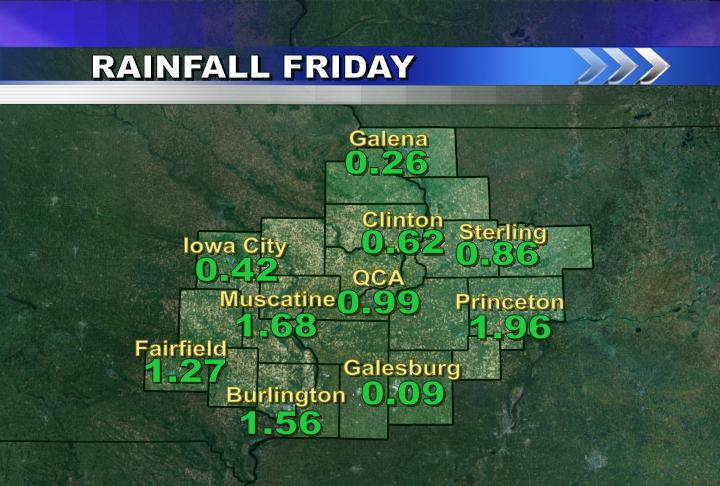
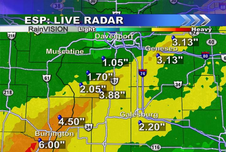
Quad Cities Criterium is underway! We had some rain and a few rumbles of thunder but it hasn't runied the excitment in the District. Clouds are giving way for some sunshine!

CBS4 Meteorologist Ted McInerney

Sunday, May 30, 2010

A Memorial Day Tradition in the QC

Every Sunday night on Ten at 10 on CBS4 I give a Hometown Forecast. If you want your hometown forecast just send me a picture from your hometown to weather@cbs4qc.com or tmcinerney@cbs4qc.com and I will use it on the Sunday night weathercast.

CBS4 Meteorologist Ted McInerney

Friday, May 28, 2010

Weather in Your Backyard!


Weather in Your Backyard is back for this summer! We had a great time with it last year and things start up Wednesday, June 2nd this year! Check out all the rules/regulations on our website cbs4qc.com.

If you're interested in hosting the first Weather in Your Backyard sign up today! (ASAP)

Thursday, May 27, 2010

Another Nice Sunset


It's another great sunset in the QC! This shot was taken around 8:40 pm from our Skycam. Notice the difference from Wednesday night's sunset to Thursday night's sunset? Fewer clouds on Thursday night thanks to lower humidity levels and the system that was responsible for the rain this week is finally moving away from our area!

Wednesday, May 26, 2010

What a Sunset!


Here's a picture from our Skycam Wednesday night...the River Bandits were in town and there was a great sunset right around 8:30 pm!

Monday, May 24, 2010

Record BROKEN!


As of 4pm it's 94° in the QC, and that breaks the record high for today!

95 ended up as the high and new record!

Record Tied (So Far)


The 3pm temperature in the QC is 93, and that ties the record high for this date, set back in 1939! Check out CBS4 News at 5pm or check this blog later to see if we not only tie but set a new record high for May 24th!

Sunday, May 23, 2010

For all those who don't like the heat & humdity


I have been enjoying the warm weather and I like tracking the severe thunderstorms but I do not like the humidity! One of our production guys Aaron Bonick just told me "to get used to it Ted!" I guess I will have to, but there are things that make it bearable.

1 Pools!
2 BBQs
3 Cool Refreshing Beverages
4 Fans
5 Making it feel like the winter with your AC!

By the way...check out the map showing snow depth... Yes there is still snow on the ground in the Rocky Mountains!

CBS4 Meteorologist Ted McInerney

Thursday, May 20, 2010

Light Rain Arriving


Light rain is now arriving in the Quad Cities...and will be with us off and on through early Friday. This afternoon the rain will be very light, totaling about .10" to .25" by dinnertime. Some of the rain could be a little heavier later tonight, but most of the rainfall totals through the next 24 hours will be under 1 inch!

Warmer weather with sunshine returns for the weekend, and by Monday we should be downright hot AND humid!

Tuesday, May 18, 2010

Best of the Class


Congrats to this year's Best of the Class!

It was a great day at the Putnam Museum as valedictorians (and their parents) from all over the QCA celebrated their accomplishments. To see this year's Best of the Class check out CBS4 News today, and watch CBS4 and RTV4 throughout June as we salute these wonderful students!

CBS4 is a proud sponsor of this event as it showcases some of the wonderful students right here in our area!

Sunday, May 16, 2010

Water Temps on The Mississippi


Water takes a lot longer to warm up than air. It also takes a lot longer to cool down. So even when we were well above average for much of April the Mississippi was mighty cold. Right now the water temp at the lock & dam in New Boston, IL is 58 degrees. So as the temperature continues to warm up and we get some pretty hot days after Memorial Day just remember the water will not be as warm. Normally in the middle of summer the water will warm up into the upper 70's!
CBS4 Meteorologist Ted McInerney

Friday, May 14, 2010

What a Flash Flood Can do...


Here's a Youtube clip of some video from WMTW TV in Maine. It shows what can happen as flood waters pass over a road...this happened in Freeport, ME. Watch the whole video and I bet you'll be surprised as what starts off as some water on the road quickly turns into a very dangerous situation!

Thursday, May 13, 2010

Finally!


Finally, skies have started to clear out! We'll see partly cloudy skies tonight and lots of sunshine over the next couple days...Here's a picture from Rock Island tonight around 8:15 pm.

Flood Threat Verifies...


Over the last few days we were worried about flash flooding across the area Wednesday night and early Thursday...and boy were those concerns warranted! Flash flooding caused big problems in Geneseo this morning as well as in many other areas mainly south/southeast of the QC. Geneseo schools were closed due to the fact that many roads (including one of the main drags through town) were covered in water. In the Quad Cities we escaped with only about 1 inch of rain, but places down to the south/southeast picked up as much as 3-6 inches of rain! Burlington was also hit hard and flooding was problematic through portions of Des Moines county in Iowa. Attached are a couple images of Doppler estimated rain totals across the area...

Wednesday, May 12, 2010

Rain Numbers...


As numbers come in regarding the rain potential Wednesday night and Thursday some outputs paint an amazing amount of rain across the QC. Here;s some guidance from the NWS HPC and this forecast shows nearly 3 inches of rain over a 24 hour period. This would certainly lead to flash flooding as a lot of our grounds are already nearly saturated from recent rains. There are plenty of models suggesting about an inch of rain also, let's hope that comes true and not the 3 inch potential!

Flash Flood Watch


****Updated with expanded Flash Flood Watch at 8pm******

We're looking at more heavy rain in the QC tonight...so the NWS has posted a Flash Flood Watch for a good portion of the CBS4 viewing area. This Flash Flood Watch is in effect through early Thursday morning, and could be extended as more rain is in the forecast for Thursday!

Tuesday, May 11, 2010

More Heavy Rain in the QC


The first round of heavy rain has moved through the area...and is now well off to the Northeast of the QC. While the rest of Tuesday looks mainly dry and cool, the next round of showers/storms is set to arrive as soon as Wednesday afternoon/evening.

The first batch of rain provided about 1 inch of rain to the QCA, officially 0.98" in Moline. The next batch of rain should drop another inch of rain across most of the area. With the next system the heaviest rain should fall just North of the QCA.

Blog images show ESP:Live rain estimates from THE LAST 24 HOURS and the SPC image is for rain forecasted to fall from 7pm Wednesday through 7pm Thursday.

Monday, May 10, 2010

Rain Getting Closer...


The first (of many) round of showers and t-storms is approaching the QC this afternoon. Shortly after 2pm the rain is just West of the Quad Cities and will be pushing through the metro area over the next few hours. While there could be a few rumblings of thunder the biggest problem we'll have this afternoon comes from some heavy rain at times. Right now from the QC toward Galesburg we're looking at .50" of rain, with some places picking up closer to an inch of rain this afternoon/evening. Check out CBS4 News at 5pm today to see when our next batch of rain is scheduled to arrive!

Sunday, May 9, 2010

A Chilly Mother's Day

Hopefully all the Moms had a great Mother's Day! It was definitely a morning you wanted to stay in bed a little longer because low temperatures hit the freezing mark for many QCA hometowns. We had a freeze warning and frost advisory posted for our area and indeed they were needed. I would hope that we don't get this cold again this season but if we do it's important for all you gardeners to remember to bring all the plants you can inside and if you can't just make sure you cover your vegetation with a sheet. There are plenty of May showers coming our way this week and temps will not return to normal until Sunday May 16th!

CBS4 Meteorologist Ted McInerney

Friday, May 7, 2010

Heavy Rain Moving Away


As expected we picked up some decent rain totals late Thursday night and Friday. Several locations ended up with around an inch of rain, with some places exceeding 1 inch! While we're expecting mainly dry (but cool) weather over the weekend, we're looking at more chances for heavy rain next week!


Thursday, May 6, 2010

Heavy Rain Early Friday...


We're looking at some heavy rain late Thursday and early Friday. Portions of the area could pick up nearly 2 inches of rain! The areas most likely to see heavy rain lie within 30 miles (either side) of Interstate 80. Here's a map from the NWS Hydrometeorological Prediction Center (HPC) showing rain totals from 7pm Thursday through 7pm Friday.

Speaking of rainfall - we've got some nice CBS4 WHBF TV rain gauges to give away...I'll give 2 away to the first 2 people that send an email to: weather@cbs4qc.com

You can pick up the rain gauges anytime during business hours at CBS4 in Rock Island!

*Update* The rain gauges for this week have been given away! Congrats to Terry, Lane and Jay. There will be more rain gauges given away in weeks to come!


Wednesday, May 5, 2010

A Cooler Day


As expected things are noticeably cooler on Wednesday afternoon compared to the 80°+ weather we had on Tuesday. One thing that hasn't changed - sunshine is still in place across most of the area! Here's a quick snapshot as of 2pm on the local temps, and their comparisons to yesterday's 2pm temps!

Monday, May 3, 2010

Warmest April on Record in the Quad Cities!


April got off to a very warm start with a record high of 85 on April Fool's Day, and never looked back! We tied the record for warmest April ever in the QC, with an average temperature of 58.5°! The only other time April has been that warm was almost 100 years ago, in 1915!

Sunday, May 2, 2010

A Big Warm Up This Week!


Is it me or are we getting some pretty nice weather this spring? Normal highs this week are around 69 degrees and on Tuesday we will climb into the lower 80's! Will it all last? After another storm systems rolls through the region on Thursday night things will cool down fast. Highs could barely reach 60 and lows in the mid to upper 30's! According to the National Climate Prediction Center the cooler weather could last longer than we would like. The map above is the 3 month temperature outlook.
CBS4 Meteorologist Ted McInerney