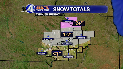
You've heard the CBS4 weather team throw out the term "Alberta Clipper" several times through this winter season. Well, another one will affect us late Monday night & Tuesday. The onset of the precipitation could be mixed with a little sleet or light freezing rain because temperatures will be near the freezing mark.
As with all clipper systems, this one is a fast mover, and the center of the low will move just north of the Quad Cities, putting the heavier axis of snow in parts of northern Iowa, Minnesota and Wisconsin. We'll still see a little accumulation tomorrow, as Anthony posted Monday morning.
Here in the Quad Cities, an inch of snow is possible, while a dusting to less than an inch will be confined to areas mainly south of Interstate 80. A few isolated areas in our far northern hometowns may see 2" or a little more where moderate periods of snow occur.
After the low moves off to the east, northwest winds will pick up tomorrow afternoon and could gust up to 35mph at times, creating limited visibility due to possible blowing and drifting snow. Winds will continue to be a factor as we see a series of disturbances riding along the jet stream this week.
We'll keep you updated. If you want to learn a little more about Alberta Clippers, a great explanation has been put together by the Louisville, KY National Weather Service. CLICK HERE


No comments:
Post a Comment