Friday, May 31, 2013

Another One For The Record Book

We just can't break the cycle of rain across eastern Iowa and west-central Illinois.  More rain is on the way to the area today, tonight, and Saturday.

As of Thursday night, we're already up to 7.94" of rain for the month of May in the Quad Cities.  That now ranks as one of the wettest Mays on record.


We're at #8 right now and it would not be out of the question to pick up another inch or two of rain if we get caught under a persistent thunderstorm.  One inch of rain before midnight Friday would push us to #7 and two inches would send us up to #3!!!

This top ten appearance comes just a month after we closed out April as one of the top ten wettest, too.  In April 2013, the Quad Cities recorded 7.21" of rain for a 4th wettest April on record finish.

We're not alone with the heavy rain.  Look at how much rain has fallen in the past week.


After more scattered showers Sunday to kick off the month of June, it looks like we'll have a chance to dry out for a couple of days, Sunday and Monday.

Make the most of your weekend!

CBS4 meteorologist Anthony Peoples

Thursday, May 30, 2013

Severe T-Storm Reports May 30

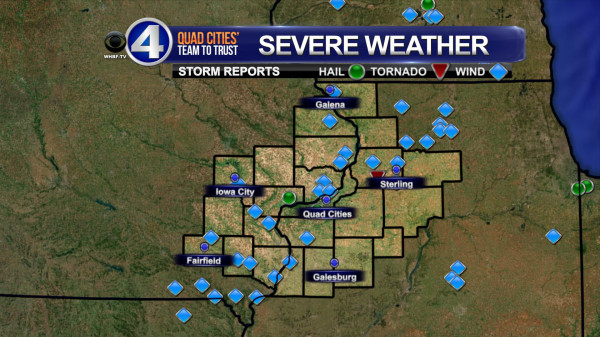
Tornadoes, hail, damaging straight-line winds, heavy rain and plenty of lightning - we saw it all across the Quad Cities area today!  Here are the local storm reports...


And we weren't the only ones dealing with rough weather today.  Look at the storm reports from across the country as of 9pm!  A powerful spring storm provides the chance for more severe storms on Friday!

Severe Weather Possible Later Today & Friday

A "Flash Flood Watch" is in effect for all of eastern Iowa and much of west-central Illinois through Saturday morning.

With plenty of Gulf of Mexico moisture in place, heavy rain is likely this afternoon through Friday evening.  This means any of the showers and thunderstorms that develop have the potential to drop very heavy rain in a short period of time.  Another 1-3" (or more) of rain is not out of the question by Saturday morning.

If the threat of flash flooding wasn't bad enough, we could see severe thunderstorms this afternoon and evening and, again, Friday afternoon.


The yellow-shaded area is where the Storm Prediction Center (SPC) expects a slight chance of severe storms this afternoon and the red shading is a moderate threat.

For our area, while there could be a tornado or large hail, the biggest threat is damaging winds.

And, we'll see another threat tomorrow.  As a matter of fact, I think we'll see a better chance for more widespread strong to severe storms Friday.  Here is the SPC outline for Friday.


As always, CBS4 chief meteorologist Andy McCray will be monitoring the skies for you this afternoon and tonight and I'll be here to cover the overnight hours and early Friday to keep you informed and safe.

Have a great day!

CBS4 Meteorologist Anthony Peoples

Wednesday, May 29, 2013

Quad Cities Rain - May 2013

It's been a wild stretch of wet weather in the Quad Cities over the last 5 days, and the last 2 months!  Remember April was the 4th wettest April on record and May is just about to enter the top 10 as one of the wettest Mays on record!  Here are a few stats from the last few days, last few months...and remember how dry last year was?  We could see more rain in the first 5.5 months this year than ALL OF LAST YEAR!


There's more heavy rain coming up Thursday and Friday and then it looks like a break from the heavy stuff, finally!  We sure could use one...

Tuesday, May 28, 2013

Flash Flooding South of the Quad Cities

Galesburg, IL took it on the chin Tuesday evening...folks there were the hardest hit from the severe t-storms and heavy rain that rolled through parts of the area.  Doppler radar estimates and spotter reports indicate about 3 inches of rain fell in about 90 minutes on Tuesday evening.  This led to major flash flooding throughout the city and throughout a portion of Knox Co. 

As of 11pm here are the active Watches/Warnings for the CBS4 viewing area, all for Flash Flooding.


And here's a pic from Alexis Cory of some of the flash flooding in Galeburg, IL...


Severe Storm Update

After a relatively dry Monday night things could get stormy again this evening. A Tornado Watch has been issued for several counties SW of the Quad Cities. This watch includes Muscatine and Johnson counties in Iowa and goes until 10pm. Thunderstorms will develop further SW of the Quad Cities and move into our area later this evening. We can't rule out a couple tornadoes but hail and strong winds will be even bigger threats once the strong t-storms arrive!

CBS4 will have a complete update on CBS4 News at 5 and 6 and remember you can also see the HD Radar, with all current warnings, right here on cbs4qc.com! (Check out the weather page)


Slight Chance of Severe Storms

Heavy rain fell to the north and the south of the Quad Cities early Tuesday.  While the metro area only picked .09" of rain in a thunderstorm, Dubuque, Iowa, saw more than an inch of rain fall in just a couple of hours before sunrise.

There is plenty of moisture available and any showers and thunderstorms that develop today, tonight, and Wednesday (and, again, Thursday, Friday, and Saturday with the next system) have the potential to drop heavy rain and cause flash flooding.

If that wasn't bad enough on top of the recent 2-6" of rain that fell over the Memorial Day weekend, with the building heat and humidity, strong to severe thunderstorms are possible later Tuesday.

Here is the outline area by the Storm Prediction Center that's under a "slight" risk (yellow shading) between 7 a.m. Tuesday and 7 a.m. Wednesday.


Large hail and damaging winds are the biggest threats with any severe storms that develop in and near the Quad Cities.

CBS4 meteorologist Anthony Peoples

Monday, May 27, 2013

The Waiting Game

With heavy rain in the forecast for tonight it's now a bit of a waiting game for the Quad Cities!  A few evening t-showers were possible but we escaped that threat...later tonight we won't be so lucky!  Showers and t-storms are now forming well West of the Quad Cities and some of this wet weather will reach us after midnight.  Before that happens we could see new development in/around the Quad Cities.  This is possible anytime from 8pm - midnight...

Here's a plot of American model rainfall over the next 7 days, notice the spike early this week!


And another product to look at, from the Weather Prediction Center of the NWS.  This shows 24 hour rain totals from Mon evening through Tues evening.  Notice the heaviest totals just West of the Quad Cities (that would be a good thing fro the QC metro area.)


Most of our area is under a Flash Flood Watch and we will see heavy rain tonight.  It boils down to this - if we pick up another inch or inch and a half we'll see more flash flooding like we saw over the holiday weekend.  If the heaviest totals (4 or 5 inches) end up in the Quad Cities we'll be in big trouble, with major flash flooding and basement troubles all over the Quad Cities!

Too Much Rain

It's been a soggy Memorial Day weekend with several rounds of showers and thunderstorms and more are on the way.

Look at some of these impressive rainfall totals from Saturday through Monday morning.


With that heavy rain and more expected later Monday into Tuesday, we remain under a "Flash Flood Watch" until Tuesday morning. 

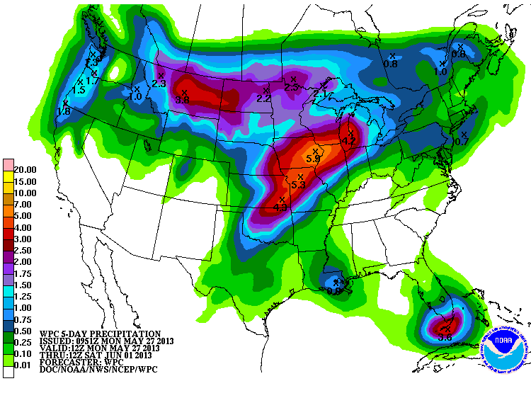
And, if that wasn't bad enough, check out the projected rainfall totals from NOAA's Weather Prediction Center from 7 a.m. Monday through 7 a.m. Saturday.


Yes, it's possible that we could several more inches of rain this week. 

CBS4 Meteorologist Anthony Peoples

Saturday, May 25, 2013

Soggy Memorial Day Weekend

It was a dreary day in the Quad Cities on Saturday with showers and even a few thunderstorms throughout the day, and temperatures hovering in the lower 50s!  Sunday looks to be well below average as well with scattered showers and thunderstorms on and off throughout the day, especially in the morning.

Temperatures look to be just a tad warmer on Memorial Day, with highs in the lower 70s.  Unfortunately, there is the chance for scattered showers and storms that day as well.

I decided to look up some weather facts for Memorial Day.
  • Average High: 76.7° -- Average Low: 55.6°
  • Warmest High: 98° on May 30, 1934 -- Coolest High: 52° on May 28, 1984
  • Warmest Low: 74° on May 26, 2006 -- Coolest Low: 36° on May 25, 1992
  • Normal Rainfall Amount: 0.14"-0.15"
Last year we had a high temperature of 89° with 0.61" of rainfall!  This year temperatures will be about 15° cooler (near our average high) but the chance for precipitation is there.  We could see 1-2 inches of rainfall through Memorial Day here in the QCA.  Speaking of rainfall, there has been at least a TRACE of precipitation measured in Moline 77 out of the last 143 Memorial Days-- that's a little over half!


Thanks to all who have and still are serving for our wonderful country!