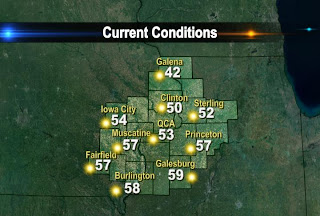
The map above shows you Saturday's high temps when most neighborhoods struggled to reach 30°. A day later, temps have climbed well into the 50s for most areas. That means temperatures are about 20-30° warmer today compared to yesterday at this time!


A weak cold front will usher in some cooler air for your Monday, but the sunshine sticks around as you begin the week. A stronger system will provide the Quad Cities with a chance of rain and snow for Tuesday and Wednesday. Keep checking back for more updates!

No comments:
Post a Comment