 |
| Barometer from Delaware (11:00 p.m.EST on 10/29/12) |

Wednesday, October 31, 2012
Low Pressures Within Sandy

Tuesday, October 30, 2012
October Lunar Halo
Anybody see the nice lunar halo around the moon on Monday night? It was a sight to see! It happens when you have cirrus (high) clouds in the place and is a result of the moonlight reflecting/refracting off the ice crystals from the cloud...sometimes tough to get a good picture of, here's a shot from the Quad Cities late Monday night.


Time Lapse of Hurricane Sandy hitting New York City
I first saw this video on the WREX Weather Blog out of Rockford...and kudos to whoever made the video!
Monday, October 29, 2012
Latest on Sandy
Here's the latest Sandy SAT/RAD picture as of Monday evening...the storm packs winds of 90 mph and is now moving WNW at 28 mph. For the latest advisories from the National Hurricane Center Click Here
 Thoughts and prayers to all those affected along the East Coast, it could be a very long 48-72 hours...and even longer with no electricity.

Impacts from Sandy
 |
| Residents in Rehoboth Beach, DE watching the high surf. (Courtesy of Carolyn Patton) |
Sunday, October 28, 2012
Sandy's Impact....

Here is a map of most weather advisories,
watches, and warnings that have been issued due to Sandy! Everything from
Hurricane Warnings, to High Wind Warnings, Flood Advisories, and even Blizzard
Warnings! IMPRESSIVE to say the least! Even Chicago is under a High Wind Watch
because of Sandy!
Sandy & the Heavy Rainfall Threat....
As of Sunday afternoon, Sandy was still a category one hurricane with winds of 75 mph. Even though Sandy is only a category one, she is still a very powerful storm due to simply her SIZE! Below are rainfall forecasts for the Northeast and Mid-Atlantic. Some areas could pick up close if not more than 10 inches of rain when all is said and done!

Sandy is now forecasted to be a hurricane through late Monday. Latest model forecasts have Sandy making landfall late Monday night into early Tuesday. That's when she will make landfall over Delaware and New Jersey.
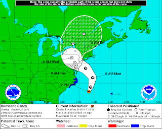

Sandy is now forecasted to be a hurricane through late Monday. Latest model forecasts have Sandy making landfall late Monday night into early Tuesday. That's when she will make landfall over Delaware and New Jersey.

Saturday, October 27, 2012
Watching Sandy's Forecasted Path...
Sandy will keep an area of high pressure from moving out of our region
over the next several days here in the Quad Cities. But, for the East Coast, Sandy means heavy rain, damaging
winds, flooding, and heavy snow.

Right now, forecasters are expecting Sandy to go from a Hurricane into an extratropical system by the end of the weekend.
Stormcast is forecasting Sandy to make landfall as an extratropical system sometime on Monday over the Mid-Atlantic states. We'll keep you posted.
Friday, October 26, 2012
With Sandy in Mind, National Weather Service Launching Extra Weather Balloons
With the threat of a catastrophically huge storm looming (Sandy) the
National Weather Service is doing all it can to come up with the most
accurate forecast possible, including launching extra weather balloons
through the lower 48 states. The Quad Cities local office is now
launching 4 weather balloons per day instead of the normal 2. These
instruments collect data such as temperature, humidity, wind speed etc
all the way up to about 90,000 feet in the atmosphere! The data
collected is sent by a radio signal back to the office, and eventually
ends up being digested and used in many ways to help with the forecast.
In the QC, meteorologists will be sending up the extra balloons through Monday morning while folks in the East and South will continue the extra balloons through Tuesday, when Sandy is expected to make landfall somewhere along the East Coast! Here are some pics from today's launch around lunchtime!
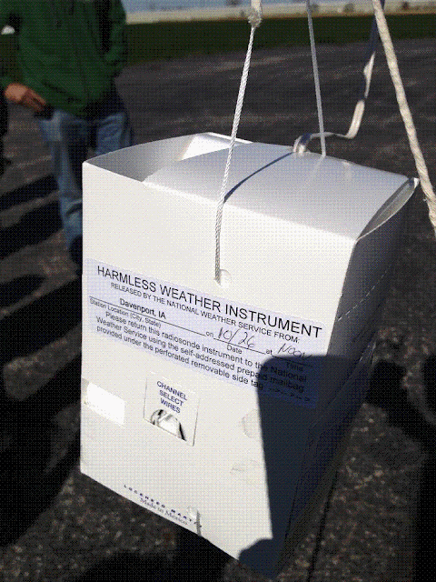


See the doppler radar in this shot!
In the QC, meteorologists will be sending up the extra balloons through Monday morning while folks in the East and South will continue the extra balloons through Tuesday, when Sandy is expected to make landfall somewhere along the East Coast! Here are some pics from today's launch around lunchtime!


See the doppler radar in this shot!
Thursday, October 25, 2012
1 Hour Temperature Drop
It was pretty easy to tell when the cold front slammed through the area earlier today...whether it was from 12 to 1pm or 1 to 2pm temperatures crashed all across the area today! In the QC we saw 19° drop from 1 to 2pm as the temp fell from 72° to 53°! Since then the temps have fallen even further, back into the lower 40s so far! Here's a list of 1 hour temp drops from the NWS in Davenport...Click Here


Subscribe to:
Posts (Atom)