Sunday, September 30, 2012

Sights of Fall around the QCA....

A few viewers sent in some beautiful pictures this weekend of the fall leaves.  Check them out!  If you have any fall pics send them our way!  You can e-mail us @ weather@cbs4qc.com or find us on Facebook by searching for WHBF TV.

This photo was taken by Randy Hale @ Lake Geode, west of Burlington, IA

This photo was sent to us by Paul Brooks of fall foilage @ Discovery Park in Muscatine

Another photo thanks to Paul Brooks @ Discovery Park in Muscatine

Saturday, September 29, 2012

Cold Weather coming to the Quad Cities this week?

We've been enjoying sunny skies and seasonable temps in the 70s for awhile now, but a cold front could change that by the end of the upcoming week.  Right now, it looks like the sunny skies will continue into Wednesday with temperatures climbing into the 70s for highs.  But, late Wednesday night into Thursday a cold front could move through the area giving us a small chance for some rain.

The bigger weather story will be the drop in temps behind the front!  On Thursday temps will be in the upper 60s (seasonable for early October), but high temperatures may only climb into the upper 50s by Friday and Saturday.  That would be well below average.

Typically, we don't reach the 50s for highs until the end of October!  So enjoy the sunshine and 70s while they last over the next few days!

Friday, September 28, 2012

Great Weather for College Football and more...


Whether you're heading to Champaign for the Fighting Illini game against Penn State or to Iowa City for the Hawkeyes Big Ten openers, it's going to be a great day do anything outdoors all across the region! 

Here are your game day forecasts for both college football games. 

Even if you're not going to any football games this weekend, be sure to get outside enjoy this nice fall weather while it lasts!

Have a great weekend!

Thursday, September 27, 2012

Why such a nice stretch of weather in the QC?

Mother Nature has put the weather in the Quad Cities on auto-pilot this week!  Nothing but sunny skies and seasonable temperatures.  So why hasn't there been much change in the weather lately? 

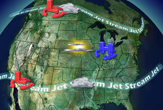
Well, the upper-level winds, also known as jet streams, that steer weather systems are rather weak.  Plus, one jet stream is located to our north and the other is to our south (shown above).  So all of the low pressure systems that usher in the clouds and the rain are riding along the jet streams to our north and south.  Keeping all the rain to our north or to our south for the most part.

 That means the area of high pressure that has been giving us the nice weather has nothing to push it out of our region.  So until the upper-level winds shift further south or north it looks like we'll be stuck in this pattern for the next several days. 

We'll keep you posted on any changes, in the meantime enjoy the great fall weather this weekend!

A Weather Satellite Error


This Monday (Sept. 24th) a weather observing satellite called GOES (Geostationary Operational Environmental Satellite) 13 failed after behaving erratic for a few days.  GOES 13 or GOES East is located over the eastern coast of the united states and it relays important weather information to meteorologists. There is good news though, GOES 14 was sent into space in 2009 as a back up to GOES 13. 

NOAA officials say GOES 14 is now the primary satellite over the Atlantic basin and the continental United States, until GOES 13 can be diagnosed and fixed.  GOES 14 also has a few extra features, including a extra sensor for relaying distress signals from emergency beacons and also it can monitor solar activity during solar storms.

The first GOES satellite was launched back in 1974 and GOES 13 was launched in 2006.  As a note, these geostationary satellites orbit the earth at the same speed of the Earths rotation.  That way it can continuously monitor weather patterns over a certain area of the Earth.

Wednesday, September 26, 2012

Walking or Running in the Rain??

An Italian university recently did a study on the best way to stay dry while it's raining.  Their findings are published in the European Journal of Physics and state that it really depends on the situation.
When the rain is falling straight down (or on top of you) or at angle towards you, your best bet is to run as fast as you can.  If the rain is falling from behind you at an angle you should run at the same pace as the wind, which should be slower than your fastest pace, but you'll still be running.

If its a complete downpour, you best bet is to actually walk!  With the increased rainfall rate you can't really outrun any droplets, but also since the ground can't absorb the rain that quickly, as you run the water will slash back up on you.  This will, of course, get you wetter that you were before. 

The best option over all is to carry an umbrella!!

Tuesday, September 25, 2012

Replacement Weatherman in Green Bay!

Green Bay NBC Affiliate Uses ‘Replacement Weather Guy’ to Poke Fun at NFL Refs - TVSpy

Hurricane Miriam Update

In the Pacific Ocean Hurricane Miriam is 405 miles Southwest of Baja, Ca. and moving NW at 6 mph.   Miriam is foretasted to gradually turn more North-Northwest today and then to the North on Wednesday.

(This is an enhanced IR image.)
The central minimum pressure is 968 mb or 28.59 inches of Mercury.  Sustained winds are at 105 mph, but Miriam is expected to begin weakening in the next 24-48 hrs. 

Surf on the south and central areas of the Baja Peninsula can be dangerous as the hurricane approaches.  Life threatening surf and dangerous rip currents are expected. 

Monday, September 24, 2012

Record Low Tied

Continuing Travis' blog from earlier today -

If you slept in, or stayed inside all morning, you might find it hard to believe we tied a record low this morning in the Quad Cities!  We started off at 30°, which equals the low mark last set back in 1989 for this date!  Cedar Rapids and several other places dipped into the upper 20s!  Believe it or not we've now seen a more than 40° range in the temps today, as highs have soared in the lower to mid 70s!  The reasons for the big swing - a gusty wind out of the SW, dry air in place and a lot of early fall sunshine!


The Coldest Morning in Months


Today we reached some chilly temperatures and we even tied our record low temperature here in the the QCA.   With clear skies and very calm winds, the temperatures dropped quickly this morning.  Just before sunrise the temperatures in the Northeast corner of the viewing area dropped an extra 3-4 degrees, to bring the lows into the upper 20s and lower 30s. 

After today our morning lows will be much more seasonable in the upper 40s and lower 50s.