Sunday, July 31, 2011

Sunday's Mississippi River Flood Update...


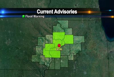
The flood warnings for Scott, Rock Island, Whiteside, and Clinton Counties was canceled by the National Weather Service early Sunday.

On Sunday, the Mississippi River dropped below flood stage in the Quad Cities.

However, Flood Warnings are still in effect for Louisa, Des Moines, Henderson, and Mercer Counties until the middle of the week.

RIVER STAGES IN FLOOD WARNED AREAS AS OF SUNDAY EVENING (8 PM):

@ Keithsburg: Sunday 14.1 ft.
Flood Stage 14.0 ft.
Monday 14.0 ft.
------------------------------------
@ Gladstone: Sunday 10.1 ft.
Flood Stage 10.0 ft.
Monday 10.5 ft.
----------------------------------
The Mississippi is near flood stage at New Boston (15.0 ft.) and in Burlington (15.0 ft.) The river is forecasted to stay near flood stage in New Boston but will crest slightly above flood stage in Burlington at 15.1 ft.

Saturday, July 30, 2011

Mississippi River Flooding Update....


The heavy rains that reaked havoc across Jo Daviess and Jackson Counties late Wednesday has caused some minor flooding along the Mississippi.

The National Weather Service has issued River Flood Warnings for communities along the river in Clinton and Whiteside Counties until 7 AM Monday. Rock Island and Scott Counties until Wednesday morning @ 230. Flood warnings are also in effect for Muscatine, Louisa, and Henry, IL Counties until Wednesday.

Initially, the Mississippi River was expected to crest @ 16.3 ft in Rock Island, but now it will crest @ 15.9 ft. on Sunday. The flood stage in Rock Island is 15.0 ft so it'll go over its banks by a foot in Rock Island causing some flooding on Credit Island, LeClaire Park, and River Drive in Moline.

Be sure to stay away from flooded areas until the water recedes. Do not drive your car through high waters or play in the water!


OTHER AREAS:
@ Muscatine: Saturday Morning 14.9 ft.
Flood Stage 16 ft.
Sunday Evening will rise to 16.9 ft.
--------------------------------------------------
@ Illinois City: Saturday Morning 13.3 ft.
Flood Stage 15 ft.
Sunday 15.2 ft.
-------------------------------------------------
@ Camanche: Saturday 16.98 ft.
Flood Stage 17.0 ft.
Sunday 16.3 ft.

Friday, July 29, 2011

Flash Flooding Pics...

Here are some of the photos of the flooding in Carroll County near Mt. Carroll. These photos were taken by a CBS4 viewer Thursday evening. If you happen to come across a flooded roadway like one of these, don't even attempt to drive through the water! Just don't do it, even if the water doesn't look that deep, or if you think your car is high enough to get over the water or other drivers are driving into the water. Most flash flooding related deaths occur from drivers trying to get through the water with their vehicles. According to studies done by the National Weather Service, more than half of all people killed by floods are people who are in their vehicles. So Turn Around!


Thursday, July 28, 2011

Amazing Video of Flash Flooding....

Here's some video of the flash flooding that took place near Dubuque Wednesday night.


Monday, July 25, 2011

Even from 22,000 Miles Away it Seems Hot!

Here's an interesting read from NOAA on how satellites that orbit about 22,000 miles up are helping meteorologists predict this year's heat wave and high humidity levels! It's an interesting read if you like weather! Cool animations included free of charge!

http://www.youtube.com/watch?v=16kMdnlEDAw&feature=player_embedded


Sunday, July 24, 2011

Finally Some Rain!


For the longest time we only recorded 0.08" of rain in the QCA for July but that changed this weekend. Just last night 1.73" of rain fell in the Quad Cities bringing our July total to 2.68"!


Many neighborhoods also picked up over 2" of rain in the last 48 hours. There are even more chances for storms later this week as another frontal system moves into the area.

Video of Flooded Streets in Chicago...

Yesterday Chicago picked up 7 inches of rain. Here is some video of the flooded streets in the city. Check out a time lapse of the rain in one of our blog posts from yesterday just below this post!

Saturday, July 23, 2011

Record Rainfall in Chicago...

Chicago storms break single-day rainfall record - CBS4 RTV4 WHBF Quad Cities, IL-IA News Weather Sports

Over 6 inches of rain fell in Chicago early Saturday morning delaying flights at both Midway and O'Hare for a time!
Check out a time lapse of the rain below.

Severe Thunderstorm Watch...


A Severe Thunderstorm Watch has been issued for Des Moines, Jefferson, Louisa, Washington, and Henry Counties in Iowa until 1 AM. The main threats with storms that become severe a are strong, damaging winds and large hail. Stay with CBS 4 throughout the night for the latest!

Thursday, July 21, 2011

Another Hot Day!


It's another hot day across the QCA, especially for places like Galesburg, IL and Muscatine, IA! In the QC the humidity has gone down a bit, so even with a temp of 96° our heat index is right around 100° instead of the 110s! There's slightly cooler weather on the way for this weekend too, check out the forecast today on CBS4 News at 5pm!