Wednesday, September 29, 2010

Dry and Sunny!


While we'll see some swings in the temperatures one thing we won't see much of over the next week - RAIN! There's a ton of sun in the forecast, hopefully you find some time to get out and enjoy the nice fall weather coming up!

Nice Knowin' Ya, Nicole!


That was quick! For a little while today T.D. 16 became Tropical Storm Nicole, and (poof) just like that it's gone! OK, it's not really gone but it's no longer a tropical storm. The NWS has determined that it's now an elongated area of low pressure, and later tonight a new (extra-tropical) low pressure will from off the Southeast coast. The threat for heavy rain is still there, and if you want to read more on that check out this link from weather.com:


Tuesday, September 28, 2010

Nicole?


We could be a few hours away from Tropical Storm Nicole! There's a new tropical depression that will be affecting Florida over the next 24 hours...For the latest check out the National Hurricane Center's website: http://www.nhc.noaa.gov/index.shtml

Monday, September 27, 2010

A Nice Night for Some Football!


What a Monday night! Tonight the Bears and Packers go head to head at Soldier Field in Chicago, and with both teams at 2-0 sole possession of first place is on the line! Don't forget to vote on who you think will win the game, there's a poll on the weather page (and sports page too, of course) at cbs4qc.com!

And by the way, the weather looks perfect! Expect a few clouds and temps in the 50s for most of the game!

Friday, September 24, 2010

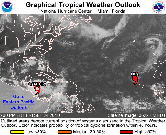
Tropics


Before we dive head-first into a cool, fall weekend here in the QC here's a quick check on the Tropics! Lisa is a hurricane, again. But that storm doesn't pose too much of a risk as it's way out in the Atlantic and heading North.

Matthew is now a Tropical Storm over land down in Central America...and will eventually curve to the Northwest, after moving due West for now. Eventually this could re-emerge in the Gulf of Mexico, if that happens things could get a little more interesting! For now though, things are relatively quiet other than these 2 storms.

Thursday, September 23, 2010

More Mississippi Flooding?


Portions of Minnesota and Wisconsin have seen TREMENDOUS amounts of rain over the last couple days, with some places picking up more than 10 inches and amounts of 5-6 inches being fairly common for a lot of places. This water will all end up in the Mississippi River and eventually work it's way downstream. That means we will see big rises on the big river next week, and depending on exactly how things go some big flooding, believe it or not, is possible!

To read more on all the rain up North check out this site from the NWS La Crosse, WI!

http://www.crh.noaa.gov/news/display_cmsstory.php?wfo=arx&storyid=57895&source=0

Wednesday, September 22, 2010

Countdown to Fall!


It won't be long now until FALL arrives! The season officially begins on Wednesday night, just after 10 pm. The fall equinox is one of 2 moments throughout the year when the sun's direct vertical rays strike right on the Equator. In the Quad Cities and throughout the world everyone will have 12 hours of daylight and 12 hours of darkness...even though the sunrise officially today was at 6:49 am and the sun set at 6:59 pm. For more on why it works out that way check out this link from Wikipedia!

http://www.en.wikipedia.org/wiki/Equinox

Tuesday, September 21, 2010

T-Storm Update


As of 2:30 pm severe storms continue around Iowa City, with a new warning in effect until 3:30 pm. So far the worst of the weather has passed Northwest of the QC, with Monticello, IA especially hard hit from winds and hail.

Severe T-Storms Developing


Severe storms have popped up just West of the QC...and they're heading East at about 45 mph. The storms are producing winds of about 60 mph and hail up to the size of golf balls in some spots! The storms should arrive in the QC between 3 and 4 pm this afternoon.