Tuesday, June 11, 2013
Heat Burst in Nebraska!
Ever heard of a heat burst? They're rare, but from time to time they do happen...and sometimes they happen not too far away from the Quad Cities! Take Tuesday morning for example - several towns in Nebraska went from the low 70s early this morning all the way up to near 100° by 7/8am!
So what the heck happened? When a decaying t-storm drops some rain into a dry layer of air the rain evaporates as it falls...this evaporation cools the air around it which also makes the air more dense than the surrounding air. That more dense air starts falling toward the ground and once all of the precip has evaporated there's no more cooling. At this point in time the descending air starts drying out and WARMING UP! At times the momentum of this falling parcel of air carries it all the way to the ground, leaving plenty of time for it to warm up!
Here's a link to a story from the NWS office in Hastings, NE, with temp spikes included! Can you imagine heading out early in the morning to temps near 100°?
Click Here for story
Cool June Heats Up
This June is off to a cool start, but that will be changing today and tomorrow.
June temperatures in the Quad Cities are running 5.7° below average and we haven't even officially hit 80° yet. However, that will occur today and tomorrow as a warm front moves through pushing highs well into the 80s and close to 90° in our southern hometowns later Tuesday.
Yesterday's 78° high at the Quad City International Airport, in Moline, Illinois, was the warmest reading this June. Looking at the first eleven days in the past five Junes, in 2008, we had already reached the 80-degree mark or higher nine of the eleven days.
However, in 2009, we had only reached 80° or higher in just three of the first eleven days.
From 2010-2012, the average was seven of the eleven days with highs at or above the 80-degree mark. As a matter of fact, in 2011, of the seven days of 80° or higher in the first eleven days, four of those days were 90° or higher!
In the Quad Cities, we've only hit the 80-degree mark 13 times in 2013. The warmest day was 90° on May 14th.
After today and tomorrow's warmth, temperatures for the rest of the week will be closer to average. Here is NOAA's Climate Prediction Center's temperature forecast for June 18-24, 2013.
Outside that dome of heat across the central and southern Plains, we may have to deal with several periods of strong to severe thunderstorms that may also bring heavy rain.
Have a great day!
CBS4 meteorologist Anthony Peoples
June temperatures in the Quad Cities are running 5.7° below average and we haven't even officially hit 80° yet. However, that will occur today and tomorrow as a warm front moves through pushing highs well into the 80s and close to 90° in our southern hometowns later Tuesday.
Yesterday's 78° high at the Quad City International Airport, in Moline, Illinois, was the warmest reading this June. Looking at the first eleven days in the past five Junes, in 2008, we had already reached the 80-degree mark or higher nine of the eleven days.
However, in 2009, we had only reached 80° or higher in just three of the first eleven days.
From 2010-2012, the average was seven of the eleven days with highs at or above the 80-degree mark. As a matter of fact, in 2011, of the seven days of 80° or higher in the first eleven days, four of those days were 90° or higher!
In the Quad Cities, we've only hit the 80-degree mark 13 times in 2013. The warmest day was 90° on May 14th.
After today and tomorrow's warmth, temperatures for the rest of the week will be closer to average. Here is NOAA's Climate Prediction Center's temperature forecast for June 18-24, 2013.
Outside that dome of heat across the central and southern Plains, we may have to deal with several periods of strong to severe thunderstorms that may also bring heavy rain.
Have a great day!
CBS4 meteorologist Anthony Peoples
Monday, June 10, 2013
Strong T'Storms this Week?
After some relatively dry weather recently in the Quad Cities the chance for showers/t'storms is back this week! While rain totals should not be overly impressive strong winds could prove to be a big problem! Warm and dry weather will be locked in place across the Southeastern U.S. and in the Quad Cities we'll find our selves right on the edge of this heat dome. Our temps will climb above normal (into the mid 80s) and we'll run the risk of strong t-storms forming along the edge of this hot weather.
You might have heard "ring of fire" this week and what that means is around the periphery of the high pressure anchored in the SE you find active t-storms that sometimes provide strong and damaging winds. Check out this surface map from the NWS WPC and note the high pressure in the SE and the warm front draped across the Quad Cities...
And here are the severe weather risks from the Storm Prediciton center for this week, again our biggest threats will come from damaging winds if we see any severe weather!
You might have heard "ring of fire" this week and what that means is around the periphery of the high pressure anchored in the SE you find active t-storms that sometimes provide strong and damaging winds. Check out this surface map from the NWS WPC and note the high pressure in the SE and the warm front draped across the Quad Cities...
And here are the severe weather risks from the Storm Prediciton center for this week, again our biggest threats will come from damaging winds if we see any severe weather!
![]() |
| Tuesday (especially late at night) |
![]() |
| Wednesday (evening t-storms possible) |
Sunday, June 9, 2013
Deadly Floods Affect Europe
Living along rivers such as the Mississippi, Rock and Cedar River, many of us have seen our fair share of flooding. While we have been having flood problems of our own, the situation is much worse in Europe.
At least 21 people have been killed by the flooding along river such as Danube, Vlatava, and Elbe. The region has been pummeled with heavy rainfall for the last week or so, and led to the bursting of a dam along the Elbe River in Germany!
Over 8,000 volunteers, including soldiers, have come together to help fill and place upwards of one million sandbags!
Tens of thousands of people have been evacuated from their homes. Here is the full story from CBS News: http://www.cbsnews.com/8301-202_162-57588399/at-least-21-killed-by-floods-in-central-europe/
Back home, rivers are slowly going back into their banks. The Mississippi River in Rock Island is expected to be back below flood stage by Wednesday.
At least 21 people have been killed by the flooding along river such as Danube, Vlatava, and Elbe. The region has been pummeled with heavy rainfall for the last week or so, and led to the bursting of a dam along the Elbe River in Germany!
Over 8,000 volunteers, including soldiers, have come together to help fill and place upwards of one million sandbags!
Tens of thousands of people have been evacuated from their homes. Here is the full story from CBS News: http://www.cbsnews.com/8301-202_162-57588399/at-least-21-killed-by-floods-in-central-europe/
Back home, rivers are slowly going back into their banks. The Mississippi River in Rock Island is expected to be back below flood stage by Wednesday.
The Mississippi River in Burlington is still experiencing major flood stage, which is not good news for Steam Boat Days this weekend.
Have a great week!
Friday, June 7, 2013
This Week's Deal
Does our recent cloudy weather or anything else have you down? Feel like a day at the spa? Don't want to spend too much money? Quad Cities Deals has just the thing for you! this week's deal is from Spa Luce in Davenport...and you can get $40 worth of treatment for just 20 bucks! Here's the fine print for this week's deal:
Spa Lucé is located in the hip and historic Hotel Blackhawk and boasts an upscale urban atmosphere with an indulgent menu of pampering services. Visit us today in downtown Davenport. Enjoy a facial, massage, manicure, pedicure, or any of our other spa services.
Voucher good through: 09/30/2013
there are still some other great deals available too at Quad Cities Deals
Spa Lucé is located in the hip and historic Hotel Blackhawk and boasts an upscale urban atmosphere with an indulgent menu of pampering services. Visit us today in downtown Davenport. Enjoy a facial, massage, manicure, pedicure, or any of our other spa services.
Voucher good through: 09/30/2013
there are still some other great deals available too at Quad Cities Deals
Thursday, June 6, 2013
Warmer Weather in the Quad Cities...Eventually!
It's gotta warm up sometime soon, right? The average temperature so far this June is way below normal and we have a few more below average days coming up! Several factors are leading to the relatively cool weather, including an abundance of clouds lately! Check out this plot of forecasted temps over the next 7 days. There are a couple things worth pointing out:
1. Notice the slow, but general warming trend thru the next 7 days. We should be closer to normal next week!
2. Look at the forecast early on in this period, namely today. The observed temps show up as black dots, notice how this afternoon the black dots are below all of the model guidance? That's because the clouds stuck around for basically all of the day, a few times we tried to clear things out but overall the clouds came out on top today!
Also, check out this forecast from the NWS CPC. It shows some warmth building in the south/southwest 8-14 days from now. Eventually we'll warm up but it definitely won't be a repeat of the heat wave from last summer! Last June by the way, we had an average high of 84.5°. This June's average high so far has been about 70°!
1. Notice the slow, but general warming trend thru the next 7 days. We should be closer to normal next week!
2. Look at the forecast early on in this period, namely today. The observed temps show up as black dots, notice how this afternoon the black dots are below all of the model guidance? That's because the clouds stuck around for basically all of the day, a few times we tried to clear things out but overall the clouds came out on top today!
Also, check out this forecast from the NWS CPC. It shows some warmth building in the south/southwest 8-14 days from now. Eventually we'll warm up but it definitely won't be a repeat of the heat wave from last summer! Last June by the way, we had an average high of 84.5°. This June's average high so far has been about 70°!
"Ring Of Fire"
June kicked off "meteorological summer", the three warmest months of the year (June, July, and August), but it sure doesn't feel like summer across the Mississippi and Illinois Valleys.
After the first five days of the month, temperatures are running more than six degrees below average with the average June temperature at 61.3°. Here's a little trivia for you: the coolest June on record in the Quad Cities was back in 1916 at 65.8°.
While cooler than average temperatures in the 70s will hold through Sunday, much warmer weather is on the way next week.
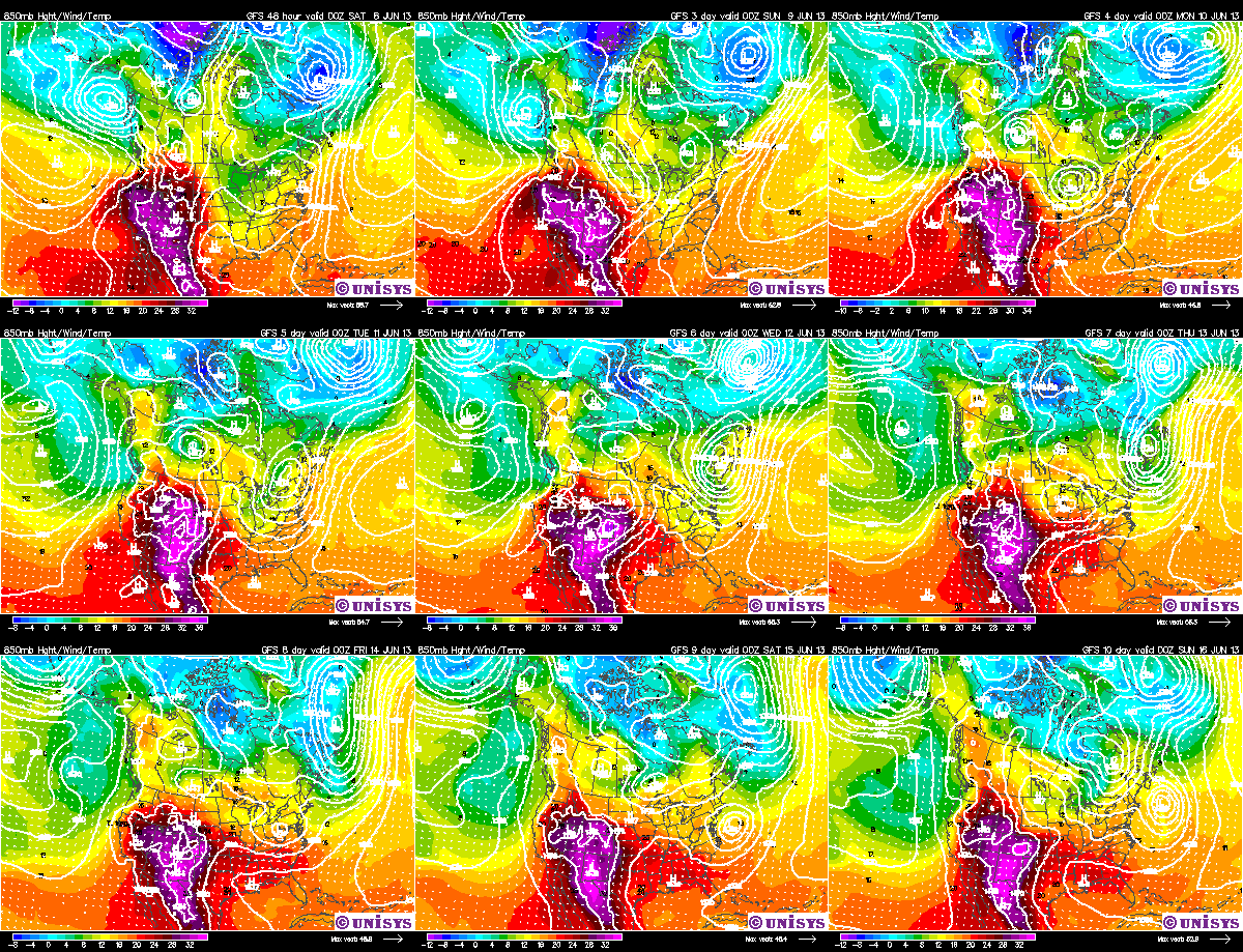
Here is a plot of temperatures over the next ten days.
Where you see the purple and red colors, that is where intense heat will be building across the middle part of the U.S. and the Southwest. High temperatures this upcoming weekend and early next week will top 100° in parts of west Texas and 90s will be likely in the Plains.
Meteorologists call this the "ring of fire". That big bubble of heat will be close to the Midwest. If it moves into our area, the forecast highs in the low-to-mid-80s next week will have to be bumped up. On the other hand, if it stays in the Plains, we could be on the outside of that "ring of fire" and have several rounds of thunderstorms that could produce heavy rain, which will cool down the temperatures.
This is definitely something to watch for next week.
Enjoy the rest of your weekend and this weekend!
CBS4 meteorologist Anthony Peoples
After the first five days of the month, temperatures are running more than six degrees below average with the average June temperature at 61.3°. Here's a little trivia for you: the coolest June on record in the Quad Cities was back in 1916 at 65.8°.
While cooler than average temperatures in the 70s will hold through Sunday, much warmer weather is on the way next week.
Here is a plot of temperatures over the next ten days.
Where you see the purple and red colors, that is where intense heat will be building across the middle part of the U.S. and the Southwest. High temperatures this upcoming weekend and early next week will top 100° in parts of west Texas and 90s will be likely in the Plains.
Meteorologists call this the "ring of fire". That big bubble of heat will be close to the Midwest. If it moves into our area, the forecast highs in the low-to-mid-80s next week will have to be bumped up. On the other hand, if it stays in the Plains, we could be on the outside of that "ring of fire" and have several rounds of thunderstorms that could produce heavy rain, which will cool down the temperatures.
This is definitely something to watch for next week.
Enjoy the rest of your weekend and this weekend!
CBS4 meteorologist Anthony Peoples
Wednesday, June 5, 2013
1st Tropical Storm of the Season!
Hurricane season is about 5 days old in the Atlantic basin now...and our first storm of the season is about 2 hours old now! As of late this afternoon Tropical Storm Andrea has formed! The storm has winds of 40 mph (barely a tropical storm) and will drop very heavy rain over the next 48 hours in portions of Florida. The storm will then move up the East Coast and spread heavy rain to portions of several states over the next 5 days or so. Here's a map from the National Hurricane Center showing the forecast for Andrea...
Monday, June 3, 2013
Cool Temps Here to Stay
Monday was about 10° cooler than normal and it looks like we have many more cool days coming up! The normal high right now is 79° and climbs to 81° over the next week. Check out this plot though...
Highs will range from the upper 60s to the mid 70s through the next 7 days, at least! There are some indications we could stay cool for at least the next 10 days! Remember last summer? It was dry and HOT just about all summer long...so far that's not the case this year!
Sunday, June 2, 2013
Recent Rains Affecting Area Rivers
May was a wet one for the Quad Cities. The airport in Moline measured 7.97" inches of rain for the month, making it the 8th wettest May on record. June has been off to a dry, cool start, but area rivers are still feeling the brunt of the recent rains.
The Mississippi River at Burlington, IA is experiencing major flooding, and is forecast to stay at major flood stage through at least the next 7 days. The crest is forecast to crest at 20.6 feet by the middle of the week, as seen on this hydrograph from the North Central River Forecast Center. Burlington had their 2nd wettest May on record, measuring 11.50 inches...6.50 inches above average!
We also can't forget about the smaller rivers in the area. The Iowa River near Wapello is experiencing major flooding and will crest at 27 feet sometime Monday.
The Cedar, Wapsipinicon, and Skunk River are other area rivers expecting a crest in the early to mid portions of the week. You can check their river levels, as well as any others, by clicking HERE.
Thanks for checking out the blog!
-Meteorologist Kyle Kiel
The Mississippi River at Burlington, IA is experiencing major flooding, and is forecast to stay at major flood stage through at least the next 7 days. The crest is forecast to crest at 20.6 feet by the middle of the week, as seen on this hydrograph from the North Central River Forecast Center. Burlington had their 2nd wettest May on record, measuring 11.50 inches...6.50 inches above average!
Moderate flooding is forecast to occur on the 'Mighty Miss' in Rock Island, cresting sometime Wednesday at 17.10 feet, and is also expected to stay above Flood Stage through at least next weekend.
We also can't forget about the smaller rivers in the area. The Iowa River near Wapello is experiencing major flooding and will crest at 27 feet sometime Monday.
The Cedar, Wapsipinicon, and Skunk River are other area rivers expecting a crest in the early to mid portions of the week. You can check their river levels, as well as any others, by clicking HERE.
Thanks for checking out the blog!
-Meteorologist Kyle Kiel
Subscribe to:
Posts (Atom)