Saturday, April 13, 2013

It could be worse...

Temperatures were once again below average for April standards in the Quad Cities on Saturday.  We reached a high a 51°, which is ten degrees below the average of 61°.  Temperatures will warm up to 70° on Sunday, but that will be short lived as we have a cold front that will move through the area Sunday evening with showers and thunderstorms and will cool down our temperatures.  However, it could be much worse!

The low pressure system that will bring us the showers and thunderstorms Sunday is bringing wintry precipitation to our friends in northern Minesota and North Dakota.  The map above is the National Weather Service's watches and warning map.  The purple color indicates a Winter Weather Advisory and the lighter pink (in the north) indicates a Winter Storm Warning.  The areas shaded in the purple can expect 1 to 3 inches of snow, with the possibility of freezing rain.  Freezing rain totals are expected to be on the order of 0.15 to 0.25 inches.  The areas shaded in lighter pink are expected near blizzard conditions with snow accumluations anywhere between 7 and 14 inches!  How about that for a late spring snowstorm?

Back here at home we could see a half an inch to three quarters of an inch of rainfall out of this system, and even more rain is expected through Thursday!

Northern Lights Tonight - April 13th

After a solar eruption earlier this week there's a good chance of seeing the Northern Lights tonight at high latitudes!  In the Quad Cities unfortunately we'll see an increase in clouds and a chance for rain after midnight, so while there would be a slight chance of seeing the aurora on a clear night here, tonight's chances look basically non-existent. 

For people in northern Minnesota and northern Wisconsin, and especially up in Alaska, there could be a beautiful display of the Northern Lights! 

Here's a forecast on which places are most likely to see the aurora:


And you can read more about the CME that is travelling toward Earth by clicking here! (From spaceweather.com)

Wednesday, April 10, 2013

Rain Totals

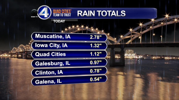
Here are some rain totals through 9pm today...and even though it's still raining the end of the heavy rain is finally in sight!  Expect the moderate rain to keep up for a couple more hours before finally pushing off to the East later tonight.  Thursday and Friday promise drizzle, and light rain, and maybe even some very light snow as temps stay cool and blustery! 


A Rainy Day
 

More Rain

There's more rain coming up this evening and tonight in the Quad Cities and the Flash Flood Watch is still in effect as of 3pm.  However, the chance for heavy rain and flooding rain is starting to go down!  On this HD Radar shot (always available by clicking here) you can see the rain is a lot lighter than what fell overnight. 
3:11pm Wednesday

The heavy rain/strong t-storms have shifted away from the Quad Cities and it's possible the Flash Flood Watch cold be cancelled early by the NWS. 

Monday, April 8, 2013

Heavy Rain and Flooding Likely

After some heavy rain early Monday we're primed for flooding issues this week as there is more rain in the forecast!  Monday night/early Tuesday is the next good chance for a soaking, with more rain chances lining up for Tuesday night and Wednesday! 

The reason for the wet weather?  A strong area of low pressure will track out of the West and move slowly across the Plains.  While some folks in the Dakotas are looking at blizzard conditions, we're looking at a perfect setup for multiple rounds of heavy rain in the Quad Cities!

Forecasted Low track
Here's a forecast from the NWS WPC (formerly the HPC) that shows rain totals from Monday night through Wednesday evening.  Rain will be heavy from Nebraska through Michigan, including right here in the Quad Cities. 
Mon night through Wednesday
 And for a local perspective, here's an in-house model which shows projected rain for the local area through Wednesday night.  Notice many spots settling between 2 and 3 inches of rain, on top of the near inch that fell early Monday! 

Friday, April 5, 2013

Big Rains Are On The Way

A nice, warm weekend is on tap for the Mississippi and Illinois Valleys. 

As it looks right now, Saturday will be the warmest day, so far, in 2013 with highs well into the 60s to around 70°.  The only drawback will be gusty winds of 20-30 miles-per-hour with higher gusts and a few scattered showers.

That rain will end early Saturday night and Sunday is looking great, as well, with some sunshine and highs in the low-60s.

Things will change by Sunday night into much of next week.  The combination of the Gulf of Mexico opening up sending moisture northward, a stalled front, and a few disturbances passing along that front spells plenty of rain for Iowa and Illinois.


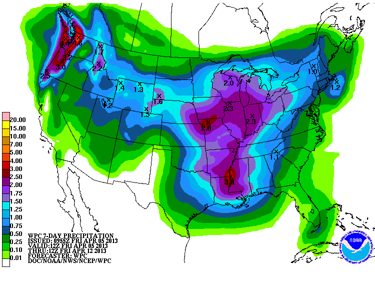
Here is a forecast projection from NOAA's Weather Prediction Center, which pretty much verifies my forecast of the heavy rain potential.


This forecast runs from this Friday morning, April 5th, through next Friday morning, April 12th.

Have yourself a great weekend and enjoy the warm weather.

CBS4 Meteorologist Anthony Peoples

Wednesday, April 3, 2013

Golf Courses Opening Up

By this time last year a lot of us already had a round of golf or 2 in the books.  This year it's quite a different sotry...but courses are finally opening up around the Quad Cities!  Last week we had video of Duck Creek in Davenport on their first day.  I've heard reports that Glynn's Creek opens Thursday and TODAY was opening day for Palmer Hills in Bettendorf.  Here's some video from Palmer Hills today, it sure looks like early season golf (the course, not the swings!)

Warmer & Wet Weather On The Way

March 2013 temperatures in the Quad Cities ended up 7.7° below average.  29 of the month's 31 days were below average.  And, things haven't changed for April.  After just the first two days of the month, we're running 12.2° below average.

You've probably already noticed a slow warming trend that's underway.  We've warmed from 41° Monday to 47° Tuesday and it should be in the low-to-mid-50s today and close to 60° Thursday and Friday.

And, this temperature forecast from NOAA for April 8-12, 2013, should make you happy if you've been wondering where spring is.
Hopefully, this warming will continue to thaw the ground and allow the spring rains to soak in instead of running off into area streams and rivers.

Unsettled weather is likely from Sunday night through the early part of next week with showers and thunderstorms. This is something that the CBS4 weather team will be watching closely.
Have a great day and enjoy the rest of your week and thank you for checking out our blog.

Meteorologist Anthony Peoples

Tuesday, April 2, 2013

Baseball Forecast

That's right, it won't be long before baseball season begins in the Quad Cities!  And while it's been a little chilly for baseball over the last couple days things should be warmer when the River Bandits open their home schedule next Thursday!  We'll have to work on that chance for rain next week though...


Check out everything River Bandits by clicking here!

Monday, April 1, 2013

Cold Spell Continues

After a decent weekend things have cooled down again in the Quad Cities!  Monday's high was a blustery 41° even with some sunshine.  The sunny skies stick around for the next few days nut the temps will be slow to warm.  In fact, we'll be close to a record low early Wednesday morning!


Record Low for April 3rd