While it feels like fall in the Quad Cities tonight the actual Autumnal equinox is only a few days away! We officially enter the new season this Saturday, September 22nd at 9:49 am! Saturday will be one of 2 days when we have exactly 12 hours of daylight and 12 hours of darkness! the same can be said for all places across the world!

Tuesday, September 18, 2012

Fall Like Temps Tonight
We're looking at the coldest weather of the season so far in the Quad Cities tonight! While we've had several nights dip into the 40s tonight we're heading for the 30s for the first time since April 27th! The normal low for tonight is 53° so we'll be about 15° below normal, and only 4 degrees from the record low of 34°!


Monday, September 17, 2012
Cold Weather Moving into the Upper Midwest...
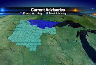
While temps around the QCA will start out in the upper 30s and lower 40s on Tuesday, temperatures in parts of the Dakotas, Minnesota, and Wisconsin are dropping into the mid to lower 30s. So Frost and even Freeze Advisories have been posted for these areas for Monday night and Tuesday morning.
We'll be dipping into the mid to upper 30s on Wednesday morning so we'll keep you posted on the potential for Frost here in the QCA!
A Foggy Start to Monday
As we anticipate an approaching cold front, temperatures dropped this morning allowing for some fog to form. With the temperature and the dew point being fairly close, plus a calm wind, patchy fog formed early this morning. A Dense fog advisory for Knox and Stark Counties in IL was issued at 8:15 am and lasts until 10 am. Use some caution on the roads and allow for extra travel time this morning.

Rain later in the day is expected to clear out the skies by early tomorrow morning. Though after the passage of the cold front temperatures really drop for Tuesday. Highs are expected to only to reach the lower 60s! The QCA also has a cool weekend ahead as Saturday is the first day of Fall.
Rain later in the day is expected to clear out the skies by early tomorrow morning. Though after the passage of the cold front temperatures really drop for Tuesday. Highs are expected to only to reach the lower 60s! The QCA also has a cool weekend ahead as Saturday is the first day of Fall.
Sunday, September 16, 2012
Chilly Low Temperatures Ahead in the QC

Overnight lows will dip into the 30s for both Tuesday and Wednesday. Our average low temperatures for this time of the year are in the low to mid 50s! Not only will low temps be on the chilly side, high temperatures on Tuesday will only reach the low to mid 60s before the 70s return on Wednesday!
Typically, we don't reach lows in the 30s until the very end of October.
Saturday, September 15, 2012
Comparing Rain Totals between August & September!

When you compare the amount of rain we got in the first 15 days of August compared to the first 15 days of September, we've picked up just under an inch more so far to start this month. BUT, we are still in the RED for the year! So far we are more than 8 inches below normal since January 1st.
While we've been picking up more rain, the latest climate outlook for precipitation still has the QCA in the below normal category over the next 15 days.

Friday, September 14, 2012
More Cool Weather Coming
After such a long and hot summer things have definitely turned the corner here in the Quad Cities! Our September temperatures have been close to normal so far, and it's looking more and more likely we'll see a couple more cool weather outbreaks before the end of the month. Early next week temps will be below average...and then the middle of the following week looks even cooler! In fact, some places in Wisconsin and Minnesota could see snow by the end of September! Here's a temp outlook for 6-10 days from now, notice the high likelihood of below average temperatures in the Quad Cities!


Tuesday, September 11, 2012
Weather Trivia
Have you heard about the CBS4 Weather Trivia contest lately? Each day (Mon- Fri) we ask a question on CBS4 News at 5pm...once you see the question you can head to our website, cbs4qc.com and click on either the CONTESTS or WEATHER tab. Submit your answer and if you get it right you are entered into the daily drawing for a nice $20 gift certificate to a local business. This week we are giving away certificates to the Boat House in Davenport, next week it's the Niabi Zoo! Each day on CBS4 News at 6pm we announce the winner (randomly chosen from all correct entries!) That means you have to get your answer in on our website between 5 and 6pm...check it out on Wednesday and you might win!
Contest page
Weather Page
Contest page
Weather Page
Monday, September 10, 2012
Fire Risk During Harvest Season
NWS offices across the state of Iowa are urging farmers to use caution this harvest season. Due to the long, dry and hot summer much of the state is still very dry. During harvest season this will increase the risk of fires throughout the Midwest. Here's a link to a page from our local National Weather Service with tips on how to stay safe this fall...
Click Here

Click Here

Changing Temps
After some cool weather this weekend (with lows dipping into the 40s)
we're looking at a quick warmup Tuesday and Wednesday. Highs will reach
the upper 80s for most of us, and that's about 10 degrees above normal
for mid September! It won't last long though...by this weekend we're
back down below average and from the looks of it more often than not
over the next 1-2 weeks temps will be below normal! Here's the 8-14 day
forecast for temperatures across the US, notice the chances of our
weather ending up below average for the time period...

Subscribe to:
Posts (Atom)