Friday, February 3, 2012

Light Mix Developing...


We're seeing a light mix of rain/sleet/snow developing across the area tonight. And there's been a little freezing rain (especially on elevated surfaces) north of the QC. While it's not a huge winter storm or anything take it easy when you're out and about over the next 24 hours...it only takes 1 icy spot to cause a big problem!

A Very Big Anniversary

So we just had the anniversary of the biggest snowstorm ever in the Quad Cities, and today is the anniversary of the coldest day EVER in the Quad Cities! On this date back in 1996 it dropped to -28°...and yes that is just the temperature not a wind chill! Here's the Almanac as of 4pm...

Thursday, February 2, 2012

Foggy, Again


6:45 pm update: Aa Dense Fog Advisory is now in effect for areas along and North of I-80, including the QC metro area. The adv. is in effect thru Noon on Friday!

Previous post
Visibilities are dropping off quickly again north of the Quad Cities! Check out the number in Clinton, IA. There's no advisory yet, but that could soon change...

Storm Shifting South


Now that our weekend storm is over land (SW of the QCA) we have a lot more weather observations...and that means we'll see fine-tuning to the model output for this weekend. That being said, it looks like the storm will not be as strong as it once did, and it will stay a little further south. All things considered it still looks like a mix of rain/snow this weekend, with the accumulating snow staying to the NW of the Quad Cities!

Update: Winter is Extended!


The most famous groundhog, Puxatawny Phil, saw his shadow this morning. This means that he predicts that winter will last for another 6 weeks. Though here in the QCA we look to be alright with highs today close to 50° and temps above average for the next 7 days.

Some interesting info; the handlers of Phil, or "The Inner Circle", ultimately decide if Phil sees his shadow or not. So even though it was a cloudy day, he still was scared back into his den. Also, since the start of the ceremonies (1887) in PA, Phil has seen his shadow 100 times and has only predicted an early spring 16 times.

Wednesday, February 1, 2012

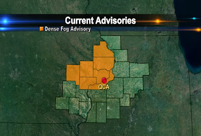
Dense Fog Developing


Dense fog is rapidly developing north of the Quad Cities right now. Visibilities are down to a quarter mile in spots and an Advisory has been issued...

February Climate Numbers...


Here are some climate numbers for the Quad Cities for the month of February. Notice the increase in daylight through the course of the month! That's one of the main reasons we see an increase in the average temps from the 1st through the 29th.

Weekend Snow Update


We're still looking at more rain than snow this weekend! The wet weather will start late Friday and continue thru early Sunday. As temps cool down there will be some wet snow to deal with too, but right now most of the accumulations look to stay North/Northwest of the QC. For the metro area I'm thinking it will stay between half an inch and 2 inches! It is still worth watching though, as some of our snow models are still suggesting 3-4 inches of snow could fall! We'll keep you posted...

Groundhog Day Tomorrow!


So tomorrow is the acclaimed "Groundhog Day"! This piece of folklore follows a groundhog to see if it sees its own shadow on February 2nd. It is said that if he sees his shadow, winter will continue for another 6 weeks and if he doesn't see his shadow, spring will... well spring early! The most famous groundhog is Punxsutawney Phil, he is in Punxsutawney, PA and emerges from his hole at 7:20 am local time tomorrow.

Usually if its a cloudy day he won't see a shadow, and the opposite is of course true if its a sunny day. The forecast in PA calls for cloudy skies, so my prediction for Phil prediction is an early Spring. Groundhog Day proponents say the groundhog is about 75% to 90% correct, but the National Climatic Data Center says its closer to 39%. Either way we are enjoying the above average temps in the QCA.

Early Fog Advisories


A dense fog advisory was issued early today and lasts until 10 am. Above is the map with the counties involved in the advisory. The grey picture is actually what our skycam looked like at 7:30 this morning. With temperatures close to freezing, some roads could be a little slick with the added moisture, so give yourself a few extra minutes today. Quick fact: fog is just a cloud that is at ground level.