Thursday, December 8, 2011

Snow Forecast for the Quad Cities


While models slowly converge on a solution for this evening's snow, totals are looking to be VERY LIGHT! In the Quad Cities we should end up with a dusting to half an inch of snow, while areas to the south could see 1/2" to 1" of snow. In other words, the shovels can stay tucked away in the garage for a little while longer! If you are heading out this evening the light snow should arrive after the evening commute but before midnight in most spots...

Wednesday, December 7, 2011

Snow...Not Yet!

While we're bound to get some snow sometime in the next few weeks it doesn't look promising over the next 48 hours. Earlier this week it looked like we could see an inch or 2 of snow Thurs/Thurs night. Now it looks like the accumulating snow will stay just south of the Quad cities and we'll have to "settle" for a few flurries and snow showers! One thing we won't escape - cold weather on Friday!

Chilly Wind Chills!


This has been the coldest morning so far this season. At one point Fairfield had a wind chill of -2°! Another cold morning is also expected on Saturday with lows in the mid-lower teens. This allows for wind chills to be in the single digits and even below 0. Lows for the rest of the work week will be fairly chilly in the mid-upper teens. There is a bit of hope though, we are back to 40° by Monday with sunny skies.

Tuesday, December 6, 2011

Winter Weather Advisory


A Winter Weather Advisory is in effect for all Iowa counties in the viewing area as well as Rock Island, Mercer, and Henderson counties in Illinois. W can expect slippery road conditions as high temperatures will be barely above freezing. Also we are experiencing light freezing drizzle and flurries from the Southwest this morning. Use caution if traveling on overpasses and elevated roadways. This advisory lasts until 2 pm CST today.

Monday, December 5, 2011

A White Christmas?


On average we see a "White Christmas" in the Quad Cities about 37% of the time...in other words, over a 30 yr period from 1971-2000 we had a total of 11 Christmas holidays with at least 1 inch of snow on the ground. This year though, with cold but mainly dry weather coming up, our chance for a White Christmas is a little lower than normal. Keep in mind, we do have about 20 days to go...and we'll keep you posted as the holiday approaches!

Sunday, December 4, 2011

Chilly Temps to Move into the Quad Cities...


This past Saturday temperatures were well above average as they climbed to near 50°.

That's partially because the QCA was sitting under a ridge in the jest stream while there was a trough in the Central Plains and Western U.S (shown above). So we weren't as cold to start the weekend. However, the trough in the jet stream to our West was keeping much of that region pretty chilly.

While this trough will lift further to North this week, it won't lift far enough to the North to keep the colder temperatures from moving into the Quad Cities (shown below).


Once, the trough moves into our region overnight lows will be in the teens with high temperatures in the upper 20s, which is well below our average for this time of the year (shown below).


Saturday, December 3, 2011

This Month's Weather Outlook...


While temperatures were well above average on Saturday, climbing into the upper 40s and lower 50s, it looks like temperatures will be near average for the rest of December.

The Climate Prediction Center is forecasting near normal temps (shown above) for this month along with near normal precipitation (shown below).

We'll have to wait and see what happens, but at least for now December may not be a month of weather extremes in the Quad Cities!

Friday, December 2, 2011

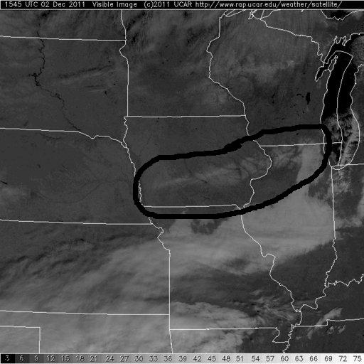
Melting Snow Seen from Satellite


Here are a couple nice satellite pics from today...the one with the black highlight on it is from earlier this morning, when there was still some snow on the ground West and North of the QC. The other pic shows the December sun has melted away the minimal accumulations from last night! Also, notice the cloud bank down to the south, it's heading in our direction for later tonight and the weekend.

Thursday, December 1, 2011

Light Snow Closing in on QCA


Portions of Northern Iowa have seen a light mixture of rain/snow over the last several hours...and that mixture is now closing in on the QCA! With temperatures dropping this evening it's likely to change over to all snow and some spots north of the Quad Cities could pick up a quick dusting to half an inch! In the Quad Cities metro area we could see some snow showers but accumulation is not likely tonight...

5 Year Anniversary

While we do have a chance for a few flurries this evening in the QCA it could be much worse! On December 1st, 2006, we picked up 8.3" of snow! And 6 of the next 7 nights saw temps drop into the single digits! Here's a link to the storm summary from the local office of the NWS!

http://www.crh.noaa.gov/dvn/?n=12%2F1%2F06snowstorm