Sunday, December 4, 2011

Chilly Temps to Move into the Quad Cities...


This past Saturday temperatures were well above average as they climbed to near 50°.

That's partially because the QCA was sitting under a ridge in the jest stream while there was a trough in the Central Plains and Western U.S (shown above). So we weren't as cold to start the weekend. However, the trough in the jet stream to our West was keeping much of that region pretty chilly.

While this trough will lift further to North this week, it won't lift far enough to the North to keep the colder temperatures from moving into the Quad Cities (shown below).


Once, the trough moves into our region overnight lows will be in the teens with high temperatures in the upper 20s, which is well below our average for this time of the year (shown below).


Saturday, December 3, 2011

This Month's Weather Outlook...


While temperatures were well above average on Saturday, climbing into the upper 40s and lower 50s, it looks like temperatures will be near average for the rest of December.

The Climate Prediction Center is forecasting near normal temps (shown above) for this month along with near normal precipitation (shown below).

We'll have to wait and see what happens, but at least for now December may not be a month of weather extremes in the Quad Cities!

Friday, December 2, 2011

Melting Snow Seen from Satellite


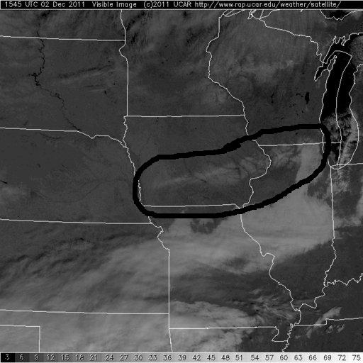
Here are a couple nice satellite pics from today...the one with the black highlight on it is from earlier this morning, when there was still some snow on the ground West and North of the QC. The other pic shows the December sun has melted away the minimal accumulations from last night! Also, notice the cloud bank down to the south, it's heading in our direction for later tonight and the weekend.

Thursday, December 1, 2011

Light Snow Closing in on QCA


Portions of Northern Iowa have seen a light mixture of rain/snow over the last several hours...and that mixture is now closing in on the QCA! With temperatures dropping this evening it's likely to change over to all snow and some spots north of the Quad Cities could pick up a quick dusting to half an inch! In the Quad Cities metro area we could see some snow showers but accumulation is not likely tonight...

5 Year Anniversary

While we do have a chance for a few flurries this evening in the QCA it could be much worse! On December 1st, 2006, we picked up 8.3" of snow! And 6 of the next 7 nights saw temps drop into the single digits! Here's a link to the storm summary from the local office of the NWS!

http://www.crh.noaa.gov/dvn/?n=12%2F1%2F06snowstorm

Wednesday, November 30, 2011

Door #1 and Door #2

OK so maybe it's more like Path #1 and Path #2 but the exact track our weekend storm takes will play a big role in the weather we see Saturday and Sunday! Right now we're leaning toward a track that more resembles #1 than #2...and that means we can expect a rainy Saturday afternoon and evening. After that a mixture of rain and snow is possible late Saturday night and early Sunday with limited, if any, accumulations! The forecast could still change but as of right now it looks like this Low will bring more wet weather than "white" weather!

A Warm Oct. and Nov. Lead to a Chilly Dec.


In the graphs to the left: Light green is the average temp, Light red is the record high, Light blue is the record low, and dark blue is the actual temp. We were above average for the first half of October. After a quick cool down we returned to average temps for the end of the month. November was much more of a roller coaster ride with temperatures. When the high was above average, it was way around 5°-10° above average! Also the coolest days of the month were only a few degrees below the average.

The average high temperature for the month of October is 64°. For October 2011 we averaged high of 67°, which is 3° above the expected value. The average monthly low for 2011 was 1° below the expected value.

The average high temperature for the month of November is 49°. For November 2011 we averaged a high of 53°, which is 4° above the expected value. The average monthly low for 2011 was 3° above the expected value.

Tuesday, November 29, 2011

Festival of Trees Fun


Here are a couple pics from the Festival of Trees Celebrity Waiter Luncheon last week...it's a fun event I look forward to all year long! This year I was lucky enough to arm-wrestle local MMA legend Pat Militech! Lucky for him I did not eat my Wheaties that day...the best news of all though is we raised some good money for a great cause!

Monday, November 28, 2011

Weekend Snow Update

We haven't seen much change in the forecast models for the upcoming weekend...and that means we're still in line for a chance of snow Saturday night and Sunday! To read a little more about what some of these numbers mean read back a couple posts on this blog...

A Cooler Week Ahead


With temperatures the past few months climbing into the 50s and 60s, we have been spoiled in the QCA. That is looking to end in the final week of November as most models are beginning to agree. High temperatures this week will stay at or around average temp, in the upper 30s and lower 40s. The coolest start to this week will be Tuesday (tomorrow) morning with lows close to the 20° mark and a brisk North wind at 10-20 mph. So grab that jacket!