If you're a sports fan you've probably heard about the Vikings/Giants game pushed to Monday, in Detroit...here's why!

Sunday, December 12, 2010
Saturday, December 11, 2010
A Little Further South...
The strong area of low pressure is looking to track a little further south, and closer to the Quad Cities. This could up the snow totals slightly for the QC, otherwise things look on track for the storm so far...

This path could lead to 3-5 inches of snow in the Quad Cities, with 5-9 inch totals not too far away, up around Rockford, IL. Stay tuned to CBS4 and cbs4qc.com throughout the weekend!

This path could lead to 3-5 inches of snow in the Quad Cities, with 5-9 inch totals not too far away, up around Rockford, IL. Stay tuned to CBS4 and cbs4qc.com throughout the weekend!
Friday, December 10, 2010
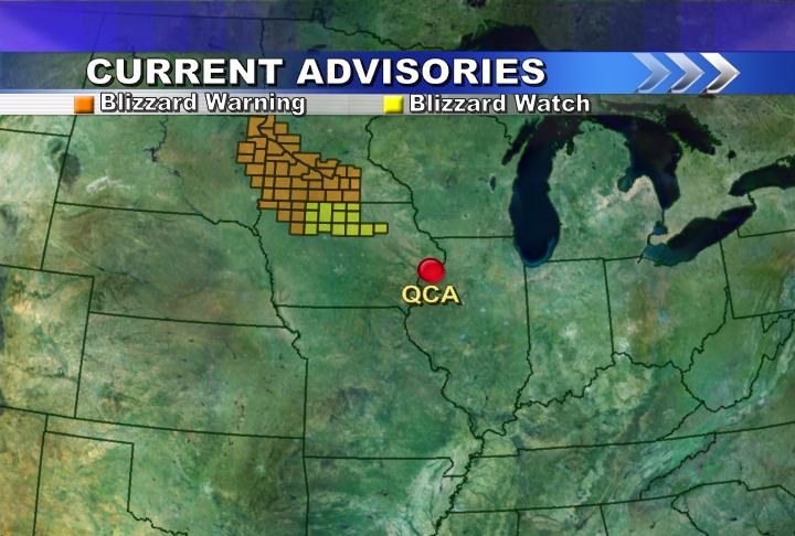
QC Added to Blizzard Watch

Our local office of the NWS has now issued a Blizzard Watch for the QC...the snow will not be overly heavy, but the winds will be strong Saturday night and early Sunday. Check us out on CBS4 News at 5 and 10 at Ten on CBS4 for the latest weekend forecast!
BLIZZARD!
It's looking more and more like a blizzard is about to unfold north of the QC this weekend! Portions of Iowa, Minnesota and South Dakota are under Blizzard Warnings, with North Central Iowa under a Blizzard Watch for Saturday. The rest of Minnesota and most of Wisconsin are under Winter Storm Watches and Warnings as they're expecting up to a foot of snow with winds of about 40-50 mph! Here in the QC we can expect a mix of rain/sleet early Saturday changing to snow Saturday evening/night. Our accumulations should be light, but we do need to be ready for strong winds and very cold weather starting Sunday!
Thursday, December 9, 2010
Storm Track Pushes North

It's looking more and more like the strong area of low pressure tracking through the Midwest this weekend will be heading North of the QC. That means we will see more a rain/sleet/snow mix Saturday afternoon and then a changeover to all snow Saturday evening. Right now it looks like our snow totals will be fairly light, ranging from 1-3 inches. Up around Madison, WI they'll see 3-6" of snow, with Northern Wisconsin picking up close to a foot of snow! One thing that hasn't changed, super cold and blustery weather begins Saturday night!
This map here from the NWS HPC shows the expected path of this weekend's storm...
Wednesday, December 8, 2010
What a Difference!

Whether or not you have snow on the ground this time of year makes a huge difference in the daily high temperatures. The last couple days have been perfect examples...check out the high temperatures From Wednesday. Also notice the visible satellite imagery from this afternoon. Notice how much colder it is where there is snow compared to SW of the QC where there is no snow on the ground? This is a result of snow's high reflectivity, or "albedo." This sends a lot of solar radiation back out to space before it can be absorbed by the ground (and eventually heat the atmosphere.) Not only does this effect daytime highs, but it also influences how cold a place will get at night during our long winter nights!
Sunday, December 5, 2010
Snow Totals

Our snow season is off to a decent start, and I bet a lot of school kids wish the snow fell on Thursday/Thursday night instead of Friday/Friday night! Officially in the QC the total was 2.5", that's taken from over near the airport in Moline. A lot of places had even more snow than that, including Davenport where the total was closer to 5 inches. The storm dropped snow as expected, with higher totals falling North/NE of the QC. The CBS4 forecast called for 4-6" NE of the QC, with a few 7 or 8 inch totals mixing in, and it turned out there were even a few 9 inch reports also, with 7" amounts being common...
Now that the snow is here, and sticking around for a while, we can expect very cold temperatures this week! This snow map is courtesy of the NWS office right here in the Quad Cities...
Friday, December 3, 2010
SNOW!

The snow has arrived, and there's a Winter Weather Adv. for the Quad Cities through Saturday afternoon. It still looks like a total of 2-4 inches for most of the QCA, with a few heavier totals NE of the QC and lighter totals SW of the QC! Take it easy on the roads through the next 24 hours, there will definitely be some slick spots tonight!
Thursday, December 2, 2010
Winter Storm Watch
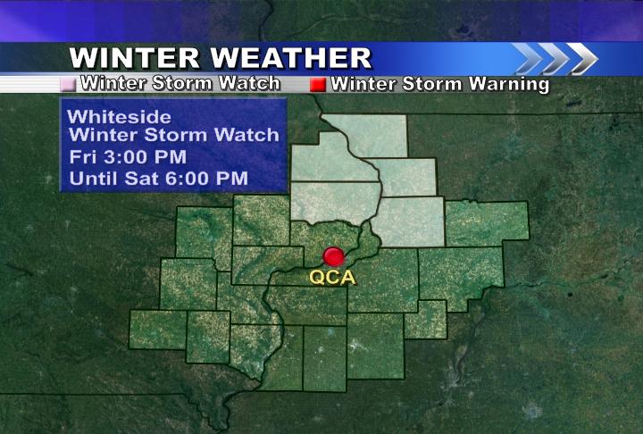
A Winter Storm Watch is now in effect North of the QC...it's looking like places North of the QC could see 3-6 inches of snow Friday into Saturday, while in the QC we can expect about 2-4 inches of snow! I'm putting the final touches on the forecast right now and you can see an updated snowfall forecast map on CBS4 News at 5pm and later tonight on 10 at Ten on CBS4!
Wednesday, December 1, 2010
Weekend Snow Update

It's still looking like we'll see our first accumulating snow of the season from Friday night into Saturday. It's possible the Quad Cities could pick up anywhere from 1 to 4 inches of snow as an area of low pressure passes just to our South. As of Wednesday night it looks like the heaviest snow should stay North of the QC...Here's model GFS model output showing about 1-3 inches in the QCA, and 3-6 inches near the Iowa/Wisconsin/Illinois border!
Subscribe to:
Posts (Atom)