Wednesday, November 30, 2011
Door #1 and Door #2
OK so maybe it's more like Path #1 and Path #2 but the exact track our weekend storm takes will play a big role in the weather we see Saturday and Sunday! Right now we're leaning toward a track that more resembles #1 than #2...and that means we can expect a rainy Saturday afternoon and evening. After that a mixture of rain and snow is possible late Saturday night and early Sunday with limited, if any, accumulations! The forecast could still change but as of right now it looks like this Low will bring more wet weather than "white" weather!
A Warm Oct. and Nov. Lead to a Chilly Dec.
In the graphs to the left: Light green is the average temp, Light red is the record high, Light blue is the record low, and dark blue is the actual temp. We were above average for the first half of October. After a quick cool down we returned to average temps for the end of the month. November was much more of a roller coaster ride with temperatures. When the high was above average, it was way around 5°-10° above average! Also the coolest days of the month were only a few degrees below the average.
The average high temperature for the month of October is 64°. For October 2011 we averaged high of 67°, which is 3° above the expected value. The average monthly low for 2011 was 1° below the expected value.
The average high temperature for the month of November is 49°. For November 2011 we averaged a high of 53°, which is 4° above the expected value. The average monthly low for 2011 was 3° above the expected value.
Tuesday, November 29, 2011
Festival of Trees Fun
Here are a couple pics from the Festival of Trees Celebrity Waiter Luncheon last week...it's a fun event I look forward to all year long! This year I was lucky enough to arm-wrestle local MMA legend Pat Militech! Lucky for him I did not eat my Wheaties that day...the best news of all though is we raised some good money for a great cause!
Monday, November 28, 2011
Weekend Snow Update
A Cooler Week Ahead
With temperatures the past few months climbing into the 50s and 60s, we have been spoiled in the QCA. That is looking to end in the final week of November as most models are beginning to agree. High temperatures this week will stay at or around average temp, in the upper 30s and lower 40s. The coolest start to this week will be Tuesday (tomorrow) morning with lows close to the 20° mark and a brisk North wind at 10-20 mph. So grab that jacket!
Sunday, November 27, 2011
Snow Next Week?
It's a little early to say for sure but we could be looking at our first decent snow of the season early next week! A storm system could first deliver rain starting late Saturday night or Sunday and then as cold air wraps into the storm the rain should change over to snow! Here's some output from one of the forecast models we look at...and I've highlighted some of the more important numbers, including precip totals (in liquid form) and the thickness parameter. Once the thickness gets to around 540 that's when you're more likely to see snow than rain.
(Any other questions about this model output feel free to leave a comment and we'll sort it all out for you!)
Saturday, November 26, 2011
A Rainy Saturday!
Wow, talk about a dreary day! Rain started up earlier today and hasn't let up as Saturday evening approaches...we're looking at a couple more hours of light rain before dry and colder weather moves in for the end of our holiday weekend. If you're heading out in the next few hours make sure the rain gear is ready to go!
Friday, November 25, 2011
Weather Headlines
Thursday, November 24, 2011
Black Friday Shopping Forecast
Tuesday, November 22, 2011
Another Top 5 List
Rain Before Turkey Day!
We are having rain showers as we start off our Tuesday, but don't let that fool you. Skies will clear by early tomorrow morning and temperatures will be on the rise! Highs for Thanksgiving and Black Friday are expected to be around 10° above average. Rain arrives for the weekend, though its a great forecast for the biggest travel day of the year (Wednesday) and Turkey Day!
Monday, November 21, 2011
Thanksgiving Day Weather History
Sunday, November 20, 2011
What A Difference A Day Makes....
Temperatures on Saturday were well above average. Most neighborhoods around the QCA had highs in the mid to upper 50s on Saturday. However, the cold front that moved through the region Saturday provided us with chilly conditions for Sunday. Check out how much the temperatures dropped around the QCA (shown above) and the Upper-Midwest in the last 24 hours (shown below).
Saturday, November 19, 2011
Above Normal Temps for Thanksgiving!
Temperatures will climb into the upper 50s to near 60° for Thanksgiving Day. The Climate Prediction Center's (CPC) 6-10 day outlook has above normal temps not only for the Quad Cities, but for much of the middle of the United States (shown above). That's because the upper-level winds in the atmosphere will be flowing in such a way that the flow pattern will symbolize the greek letter omega. So this upper-level wind pattern is known as an Omega block (shown below).
That means there'll be a trough in the Eastern and Western U.S. with a ridge in the middle of the Country. When we are under the ridge our winds shift out of the South. Those southerly winds bring up warmer air from the South. So temps for Thanksgiving and Black Friday will be 10-15° above normal.
Friday, November 18, 2011
A Warm Fall in the UK
With abnormally warm fall temperatures in the United Kingdom some wildlife are getting confused. These 3 little ducklings were born this Autumn as the warmer weather convinced the mother that it was spring. Also local gardens have rose blossoms and even a banana tree has begun to bear fruit. The quad cities have had some warmer weather but not as warm at the UK.
Thursday, November 17, 2011
Not as Cold Tonight
Severe Storms in the Southeast.
In the Southeast trees are ripped from the ground, cars flipped and houses are damaged. A cold front and warm moist air from the Gulf of Mexico combined to create severe weather. 83 reports of strong winds in 7 different states, 9 reports of large hail in 2 states, and 16 reports of a tornado in 4 different states. So far 3 people are reported to have been killed by a possible tornado as a house was damaged in South Carolina. 1 fatality was reported due to high winds knocking a tree onto a car in Georgia. The front has moved out of the Southeast but is still giving the Mid-Atlantic states rain this morning. No severe is expected today.
Wednesday, November 16, 2011
Cold Night Coming Up!
Tuesday, November 15, 2011
Wild Temperature Ride This week
After 3 days of above average temps Mother Nature's about to even things out over the next few days! The normal high right now is 50° and we'll be back down below average for the next 48 hours! The mild weather's not done yet though, as a nice rebound heads our way for the end of the workweek and the weekend!
Follow us on Facebook, Twitter, cbs4qc.com etc!
Another Mild Day
Monday, November 14, 2011
Midwest Severe Weather
A stormy day is unfolding across portions of Illinois, Indiana and Ohio! There are multiple tornado watches in effect as well as a few warnings! So far there has been 1 tornado reported in Illinois, not too far away from Champaign! The good news for folks in the Quad Cities is all this nasty weather will stay away from us...but people in Indianapolis, Dayton, Cincy, Columbus etc need to be ready for severe weather today!
Sunday, November 13, 2011
Chilly Weather Coming to the Quad Cities...
It was a beautiful weekend! Skies were filled with sunshine and some strong southerly winds helped temps climb into the 60s and even the 70s in some places on Sunday. However, some cold weather is going to move into the QCA by the middle of the week.
Below is an example of a forecast model we use to determine temperatures. This model is for Wednesday evening. The blue colors show areas of colder temperatures. Check out how far South the cold air could reach by Wednesday evening. It looks like neighborhoods in Northern Oklahoma and Northern Arknsas could even get a taste of the cold weather!
Right now, we are forecasting highs on Wednesday to be in the mid 40s with lows dropping into the low to mid 20s! A taste of winter is heading our way this week!
Saturday, November 12, 2011
A Windy Sunday.....
Southerly winds have been helping our temps stay on the comfortable side this weekend. While winds were sustained out of the South from 10-20 mph on Saturday, they'll be a bit stronger on Sunday as a cold front pushes through the region.
Ahead of the front, winds will be sustained out of the Southwest from 20-30 mph with strong winds to East of the Mississippi River.
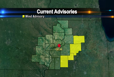
Lee, Stark, Knox, and Bureau Counties are under a Wind Advisory from 8 am to 6 pm Sunday because winds will be sustained out of the Southwest from 25-35 mph with gust up to 45 mph (shown above, shaded yellow).
Friday, November 11, 2011
11/11/11 Storm!
What a storm it was rolling through the Midwest on 11/11/11! Obviously after our nice weather Friday I'm talking about 1911, not 2011! It's known as the Great Blue Norther and it brought the quickest, biggest temperature drop ever to many cities in the Midwest! In the Quad Cities we had a high of 76° and then a low of 14°...with about 3/4 of an inch of rain and a trace of snow! Some places set record highs and lows IN THE SAME DAY! For more check out the link to a Wikipedia article!
http://en.wikipedia.org/wiki/The_Great_Blue_Norther_of_11/11/11
Storm Still Impacting Alaska
The large low pressure system that was giving blizzard conditions to Alaska earlier this week is still giving them wintry weather. Through today, there are still blizzard, winter weather and coastal flood warnings. The conditions along the western coast consist of 3-6 inches of additional snow, winds gusting 30-50 mph, blowing snow, freezing rain and seas up to 12 ft. The storm is expected to pass by late Sunday with snow still falling on Saturday.
Thursday, November 10, 2011
A Chilly Thurs. Night
Wednesday, November 9, 2011
A Wet November!
Rain, Snow and now Wind
Tuesday, November 8, 2011
Bering Sea Superstorm
Folks in Alaska are about to be slammed by one of the biggest storms to ever affect the state! They're looking at hurricane force winds and more than a foot of snow in some places! It's an amazing storm and here's some of what meteorologists at the NWS are saying:
THE HIGH SEA LEVELS COMBINED WITH HIGH WAVES WILL PRODUCE SEVERE BEACH EROSION AND MAJOR COASTAL FLOODING ALONG THE NORTHERN AND EASTERN SHORES OF NORTON SOUND AND ALONG THE BERING STRAIT COAST. HIGH WATER LEVELS WILL PRODUCE COASTAL FLOODING ALONG THE SOUTHERN SHORE OF NORTON SOUND. STRONG WINDS AND WAVE ACTION MAY PUSH ICE IN NORTON BAY ON SHORE.
Blinding snow is another big concern. NWS cautioned:
THE STORM WILL ALSO PRODUCE SIGNIFICANT SNOWFALL AND BLIZZARD CONDITIONS OVER ALMOST ALL OF THE WEST COAST TUESDAY NIGHT AND WEDNESDAY. SNOWFALL AMOUNTS OF AS MUCH AS 14 INCHES ARE EXPECTED ALONG THE SOUTHERN SEWARD PENINSULA COAST AND IN PARTS OF THE INTERIOR SEWARD PENINSULA.
This storm is huge and will no doubt be making huge news in Alaska for the next 48 hours!
Accumulating Snow North of the QC!
While we could see some light snow mixing in with the rain early Wednesday places North of the Quad Cities could actually see some minor accumulations! Maquoketa and Galena (among other places) could see up to 2 inches of snow early Wednesday! A Winter Weather Advisory is in effect for Jo Daviess and Jackson counties until 9 am!
Monday, November 7, 2011
Heavy Rain on the Way
So far this month we've already seen more than an inch of rain in the Quad Cities...and there's a lot more on the way! Rain begins Monday night and lasts through early Wednesday! It looks like most places around the QCA will see between 1 and 2 inches of rain, and this graphic from the HPC shows potential for up to 3 inches of rain! Normal rain for the entire month of November in the Quad Cities is only 2.56"!
Sunday, November 6, 2011
Latest Rainfall Totals for Tuesday from Stormcast...
According to Stormcast Sunday evening, it looks like many neighborhoods will pick up at least an inch of rain from the system thats going to reak havoc late Monday night into early Wednesday morning.
Areas to the East of the Mississippi River could pick up just under an inch by Wednesday morning while areas West pick up an inch or more. We'll keep you updated throughout the week on CBS4! Have a great week.
Saturday, November 5, 2011
Some Heavy Rains Could Fall in the Quad Cities....
It's going to be pretty nice to start the week. There will be a great deal of sunshine on Monday, but late Monday night into Tuesday a strong area of low pressure is going to move into the Quad Cities and produce a good deal of rain.
Some weather models are suggesting the rain could be rather heavy on Tuesday. Check out the forecasted rain totals for this first half of the upcoming week (shown below). The darker, brighter colors inidicate areas of heavier rainfall.
Neighborhoods around the Quad Cities and in Eastern Iowa are shaded in purple. This suggests that we could pick up close 2 inches of rain or even a little bit more by Tuesday night (the scale is in inches on left hand side of the map).
Areas to the East of the QCA, like Princeton, IL, Sterling, and Dixon, could pick up a little less (shaded in light blue), but it still would be an inch or more! We'll have to wait and see, so stay with CBS4 for the latest!
Friday, November 4, 2011
Weekend Forecast
The Mercury Rises For The Weekend Before Plunging...
Thursday, November 3, 2011
More Northern Lights?
Remember the great light show everyone was talking about a couple weeks ago? We might get another shot at seeing the Northern Lights over the next week or 2! There's been a lot of solar activity in the last 24 hours and one of the solar storms could send some extra energy in our direction...if that happens the aurora could be visible again. We'll keep you posted! Here's a site where you can read all about it!
http://spaceweather.com/
Sports Anchor Wins Jackpot
Check out this video as a sportscaster wins a $2,000,000 lotto live on the air! I'm pretty sure he's Canadian...too bad it wasn't Jay Kidwell! The good stuff starts around 1:30 into the video!
Rain Coming to an End
Tuesday, November 1, 2011
Rain Totals Thursday
October Roundup
As we enjoy some warmer than normal weather on the 1st of November here's a quick summary for the month that was October 2011!
Warmest Temp: 83° on Oct. 8th
Coolest Temp: 27° on Oct. 28th
Avg. Temp of 53.9° was 0.7° above the normal average of 53.2°
The biggest story of the month was the lack of rain! In October we picked up 0.67" of rain, compared to the average Oct. rain of 2.97"!
Warmest Temp: 83° on Oct. 8th
Coolest Temp: 27° on Oct. 28th
Avg. Temp of 53.9° was 0.7° above the normal average of 53.2°
The biggest story of the month was the lack of rain! In October we picked up 0.67" of rain, compared to the average Oct. rain of 2.97"!
More Snow Out West
Subscribe to:
Posts (Atom)