Monday, January 31, 2011

Blizzard Warning


It's official...A Blizzard Warning has been issued for the QC and all surrounding areas. In the QC the Warning goes into effect at 3pm Tuesday and lasts through Noon on Wednesday. After a brief lull in the snow late Tuesday morning and early afternoon the snow will resume Tuesday afternoon, and pick up in intensity Tuesday night and early Wednesday. Add 30 mph + winds to the mix and blowing snow will be a big problem as well. Visibilities could be near zero for an extended time Tuesday night and Wednesday. Stay tuned to CBS4 and cbs4qc.com and this weather blog for continuing coverage!

One for the Record Books?


While I finish up the forecast, and snow totals are coming soon by the way, here's a look at the biggest snowstorms in the Quad Cities, since records began (decades ago.) It doesn't look like we'll be setting a new record this week, but the snow WILL BE EXTREMELY HEAVY nonetheless. Blizzard Warnings are in effect for portions of the CBS4 viewing area. More blog updates to come...

Latest Snowfall Potential


Friday, January 28, 2011

Early Week Snow?


After a respectable (as far as the temperatures go) day on Friday we'll shift our focus to the chance for some early week snow...as most of the weekend should be fairly quiet. By early next week an area of low pressure will be tracking South of the QC. What's important is HOW FAR South the low tracks...if it stays way down by the Gulf Coast our snow will be pretty light (an inch or 2) but if it tracks a little closer to us we could end up with several inches of snow Monday night through Tuesday. Here's one forecast model showing the low taking a path that would give us a 2-3 inch snow early next week.

Wednesday, January 26, 2011

Snow Totals


It's looking like light snow in the QC for Thursday afternoon, while there could be an inch or 2 NE of the QC most of us are looking at about half an inch of snow!

Website poll


Don't forget to vote on the poll recently posted on the weather page at cbs4qc.com ! Have you had enough of the wintry weather yet? I voted yes...

Tuesday, January 25, 2011

Wintry Weather Stays East...


While our tranquil (boring perhaps?!) weather continues folks from Tennessee to New England are dealing with wintry weather...here's a Tuesday afternoon look at Winter Storm Watches and Warnings!

Monday, January 24, 2011

Another Big East Coast Storm?


While things will remain fairly quiet around here this week it could be a much different story for some of our country's biggest cities along the East coast! Here's a graphic showing the likelihood of picking up at least 4 inches of snow...and it could be significantly more than that by the time things wind down Thursday night/Friday! If your travel plans take you to the East coast this week, stay tuned...it could be another travel nightmare late this week.

Saturday, January 22, 2011

Not As Cold But Still Cold!

Our normal high temperature in Moline is 30° and the low is 12°. Our high on Saturday was 20° and low 10°. It looks like we will be staying below average for much of the week except Friday!

A fun weather fact: The worlds highest temp today was 108° in Telfer, Australia.
The worlds' coldest spot was in Fort Yukon, Alaska at -45° so far.....

--TED

Friday, January 21, 2011

More Cold Later This Month?


Over the next few days we can expect a small reprieve from the super cold weather over the last 24 hours...but it COULD turn even colder for the end of January and early February! This is a long way off and you can't count on the forecast models at this point but the GFS (1 computer model) is showing another big time Arctic outbreak late this month! Click on the image to see potential lows of around -20!

More Light Snow


While it won't pile up too much across the QC tonight there is more light snow on the way. As the light snow continues sinking Southeast we'll see snow showers off and on through portions of our Friday night. Some spots could see up to 1 inch of dry, powdery snow!

A Frigid Start!


What a cold morning! If you were out and about early on Friday I hope you were bundled up! As wind chills hovered around -20 for a lot of us the actual temps dipped well below zero also! Areas North of the QC ended up even colder than the Thursday night forecast!

Thursday, January 20, 2011

Cold Weather on Track...


We've been talking about a big-time cold weather outbreak for the last couple days and it looks like everything is still on track for tonight! We'll see a significant temperature drop this evening and head down below zero in the QC by around midnight. Winds will be up for a little bit this evening (20-25 mph gusts) and then by the time winds slack off late tonight the temperature will be cold enough where we don't need much wind at all to make it feel like it's about -25°! That's why we have a Wind Chill Advisory in effect through early Friday...make sure you BUNDLE UP if you have to go outside. This is the type of weather you can't afford to be caught off guard in outside!

Wednesday, January 19, 2011

COLD Weather Coming Up!


Here are the 9 pm temperatures from Wednesday night. See the near zero degree weather off to the NW? That's heading our way and 24 hours from now we'll be getting close to 0°, and heading below zero later Thursday night!

Tuesday, January 18, 2011

Snow Totals

With more snow on the way for late Wednesday and early Thursday here's a quick look back to snow totals from Monday. Map courtesy of the NWS in Davenport!


Here's the address for their recap on the event...


http://www.crh.noaa.gov/news/display_cmsstory.php?wfo=dvn&storyid=62830&source=0

Monday, January 17, 2011

Freezing Rain


Ever wonder why sometimes in the winter we get snow while other times sleet or freezing rain might fall? The answer can be found by studying the temperatures near the ground and up above in the clouds that are producing the wintry precip! Most people would agree freezing rain is the worst kind of weather to try and travel through...here's what conditions are favorable for freezing rain to fall during the winter season!

Friday, January 14, 2011

Weather Anniversary


This weekend (Jan 15, 16) marks the second anniversary of some of the coldest weather EVER in the QC! Early in the morning on January 16, 2009, the temperature plummeted to -27°! That's a record for that day, and it missed the coldest temperature ever in the QC by one degree! Thinking back to mid January 2009 makes our forecast for this week seem not so bad, right?

On track...


Even though there is still some cold weather in the forecast over the next week or so it still looks like we might warm up for the end of January! Here's an update on the blog post from yesterday...

Thursday, January 13, 2011

Cold, Cold...then Not as Cold?


We've definitely got some cold weather coming up in the QC. In fact, the next week to week and half looks downright frigid at times. However, by the time late January rolls around we might actually start heading in the right direction! Here's a look (above) at likely temperature ranges for the next 6-10 days (colder than normal) and for the next 8-14 days (not quite so bad!)

Wednesday, January 12, 2011

49/50!


49 of the 50 states have some snow on the ground! Florida is the one state with absolutely NO SNOW on the ground...even Hawaii has some snow on mountaintops! While this might seem a little unusual it was just last year (Feb) when ALL 50 states, even Florida, had snow!

Snow Update


Don't worry, there's not a whole lot of snow in the forecast! Now's a good time though to take stock on our seasonal snowfall so far...the official total for the QC comes from Moline, where 21" of snow has fallen so far this (snow) season. We're about 5 inches above normal for this point of the season!

Davenport has an even higher total though, with 27" of snow so far this season!

Tuesday, January 11, 2011

Snow Totals

Here's a nice snow total map from the NWS in Davenport...


Official totals for the QCA:
Moline 2.9"
Davenport 2.5"

Winding Down...


The bulk of the accumulating snow is now passing to the East of the QC, and we'll just a see a little more LIGHT snow through the rest of our Tuesday afternoon. So far in the QC we've seen 2.7" of snow...and I'll have a final tally on CBS4 News at 5in High Definition!

Monday, January 10, 2011

Winter Weather Advisory Extended North


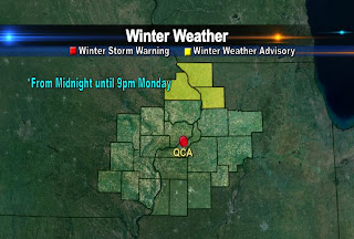
Earlier today the QC was just North of a WW Adv but now we're not looking quite so lucky! The NWS in Davenport has just extended the Advisory North to include the QC Metro area. While we're not looking at a whole lot more snow than originally thought, we could see 3-5" by late Tuesday, so the Advisory is in place now through Tuesday at 6pm. Feel free to send any snow reports from your yard to:

weather@cbs4qc.com

Snow to Begin Shortly...


We're looking at a prolonged, light snow event unfolding from Monday evening through Tuesday evening. The heaviest totals will fall SW of the QCA, with some folks in South-Central Iowa picking up close to 8 inches of snow!
As far as timing goes, the snow should start in the QC by around dinner time tonight!

Friday, January 7, 2011

Cold Weekend Ahead...


Here's the RUC (Rapid Update Cycle model) look at temperatures for later tonight, this is around midnight as we fall back into the single digits across most of the area. By early Sat morning we should be down around 7° in the QC! And don't expect much of a warm-up anytime this weekend! Check out the forecast in HIGH DEFINITION today on CBS4!

Have a nice weekend, and stay warm!

Wednesday, January 5, 2011

Cold Weather Coming...


While temperatures are expected to cool a little over the next few days we're looking at a more significant cool-down by the middle and end of next week. Here are a couple outlooks from the Climate Prediction Center and they show a high chance of cold weather next week!

Snow Chances...


While there are bound to be a few more changes in the models over the next couple days the chance for snow early next week has gone down a bit compared to yesterday. It's now looking like the main area of low pressure will be close to the Gulf Coast, and if that's the case our heavy snow chances will be diminished dramatically. Stay tuned though for the next couple days, as we officially iron out the fine details...

Tuesday, January 4, 2011

Snow Early Next Week?


While we do have a couple chances for light snow this week at this point in time it looks like we could have a fairly significant snow early next week. There are a couple different scenarios that suggest snow Monday into Tuesday, and it could be several inches of snow early next week! I do want to point out it's a little early and things could change, but as of now early next week looks snowy!

Here's a snapshot of the GFS model which shows an area of low pressure passing South of the QCA next Monday evening, and that's a perfect path for snow!

Monday, January 3, 2011

Anniversary...


Today marks a big weather anniversary in the Quad Cities...here's an interesting little tidbit from the NWS in Davenport!

HISTORICAL RECORDS...TODAY MARKS THE 40TH ANNIVERSARY OF THE BIGGEST 24 HOUR SNOWFALL IN THE QUAD CITIES RECORDED HISTORY. ON JANUARY 3 1971...16.4 INCHES OF SNOW FELL AT MOLINE. SOME LOCATIONS IN DAVENPORT HAD 18 INCHES WHICH I MEASURED. THIS OCCURRED ON A SUNDAY AND SCHOOLS WERE CLOSED FOR THE NEXT TWO DAYS WHICH WAS FUN
FOR THIS KID. ..HAASE..