Friday, December 30, 2011

Another Warmer than Normal New Year's Eve in the Quad Cities?


Right now, it looks as though it'll be another warm day in the Quad Cities on New Year's Eve. High temps are forecasted to be in the upper 40s with some neighborhoods reaching the lower 50s on Saturday with a mix of sun and clouds.

During the past 11 years, temps have been above our average high of 31° on New Year's Eve 64% of the time. Last year, we hit 55° on New Year's Eve. However, a cold front knocked our temps down into the teens New Year's Day morning and highs last year on New Year's Day were near 30°.

It looks like a similar thing will happen this year although it won't be as chilly on New Year's Day. A cold front will move through late Saturday night sparking a few light rain/snow showers and it'll drop our temps back into the mid to upper 30s for New Year's Day.

Thursday, December 29, 2011

So will January be any Colder than December?


The Climate Prediction Center's January outlook has us with a 40% chance of having above normal temps. However, precipitation should be right around average for next month.

But, it looks like January will start out on a colder note. So far our forecast for the first few days of next week has lows in the teens with highs in the upper 20s.

Wednesday, December 28, 2011

So How Many Days Have Temps Been Above Average?

The month of December has been anything, but normal. From the lack of snow to above normal temps! So how many days this month has the Quad Cities experienced warmer than normal temps?

Well, approximately 20 days have been above average so far this month of the 27 days we've gone through so far! The warmest day was December 15th! That's when we hit 58° for a high. The coldest day was all the way back on December 9th when we only climbed to 27°.

Below is a chart showing each day's high temperatures that's recorded by the National Weather Service in Moline from December 1st through the 27th. The white line represents the average temperatures. Check it Out! It's unbelievable! The warmer than normal weather will last through the New Year's holiday before more seasonable air arives next week.

Tuesday, December 27, 2011

How Does This Year's Precip Measure Up?


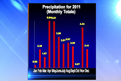
While we've had almost two and half inches of precipitation for the month of December, it has been rather dry recently in the Quad Cities. Right now, we are about 3 inches below normal for the year. 2012 is just days away and there are only a few more very small chances for some rain and snow.

In 2010, we had 44.98" of precip, so far in 2011 we've measured 34.58". That's about a 10 inches less when compared to a year ago.

Most of this year's rain fell during the spring, in April and May when many folks were dealing with flooding along the Mighty Mississippi.

October has been our dryest month this year. During October we only managed to get 0.67" of precip.

Sunday, December 25, 2011

A Look Back...

Our high temperature on Christmas Day 2011 was 46° which is about 15° above average for this time of year. Right now, my forecast has temps remaining above average as we head into the New Year's weekend.

So how do the forecasted temps right now compare to the actual high temps we had during the same week last year?

Well, below are two charts to give you an idea. The top one is the forecasted highs as of Christmas Day for the week ahead and the bottom graph are last year's recorded high temps in the Quad Cities for the same days.

While we did have two really warm days last year, we did deal with more seasonable temps for much of the holiday week in 2010.


Saturday, December 24, 2011

How Does This Christmas Compare to Year's Past?


Right now, I'm forecasting a high temperature of 42° for this Christmas. That's about 10° above average for this time of year. Our average high on Christmas is 32° with an average low temp of 17°.

While 42 degrees is above normal and doesn't really make it feel like Christmas, it seems like it's not really that uncommon for the Quad Cities to have highs around 40°. Check out the last 5 Christmas' high temps! Only two of the previous five Christmas' were temps around average! Have a great holiday!

Thursday, December 22, 2011

Daylight Numbers...


So I'm sure you know it is now winter...and the days are getting longer! How much longer...and how quickly? Check out this chart that shows the amount of daylight for a few particular days...

(This chart was made on Wednesday)

Wednesday, December 21, 2011

A Slow Start...

I was checking a weather friend's blog (from WREX TV in Rockford) and saw they had posted something along these lines so I thought I'd add up our numbers for snow season-to-date. This explains why everyone's asking "Where's the snow?" These totals take into account snow from October-December 21st for each year listed...

The Winter Solstice


Winter officially begins TONIGHT! At 11:30 pm the sun will be directly over the Tropic of Capricorn, which is about 23.5° south of the Equator. Here are some of the things this means:

1. This is our shortest day of the year as far as daylight goes.
2. It's the 1st day of winter.
3. It's the 1st day of summer in the southern Hemisphere.
4. The North Pole is in the middle of a 6 month stretch of darkness!

Tuesday, December 20, 2011

CBS4 Holiday Promo

Happy Holidays from everyone at CBS4!

Chilly Weather in Texas


With blizzard warnings in Northern Texas and into Kansas, temperatures have defiantly dropped behind a strong cold front. Above are two maps, one with the 24 hour temperature change and the other depicts the surface low and trailing cold front. Temperatures have dropped upwards of 20 degrees from San Antonio all the way through Kansas. The deepening low has pushed through Texas leaving snow and temps in the 30s. Luckily we won't be seeing much of this storm as it passes mainly to our south. We had similar conditions a few weeks ago with temperatures falling more than 15 degrees throughout the day. We don't expect any big drops in the temperature as we head towards the Christmas weekend.

Monday, December 19, 2011

Blizzard!


Don't worry...not in the QCA. We're looking at a light mixture of rain/snow early Tuesday but some folks in Nebraska and Colorado are looking at heavy snow and strong winds! Check out the map -

Yellow - Winter Weather Advisory
Red - Winter Storm Warning
Orange - BLIZZARD WARNING

Sunday, December 18, 2011

What A Difference A Year Makes!


Here are two maps showing the snow depth (snow on the ground) from around the U.S. The map above shows the snow depth from last year at this time and below is the current snow depth (as of this Sunday).

Last year at this time we had a few inches of snow already on the ground and of course there's nothing on the ground out there right now. We aren't the only ones not seeing much in the way of snow.

Folks in the Dakotas, the Mountains in California and Nevada along with areas near the Great Lakes aren't getting as much snow as they did by this time last year!

Saturday, December 17, 2011

Where's The Snow?


So how much snow usually falls in the Quad Cities by the middle of December? Well when you look back to the previous five years (from 2006-2010), we typically would've already picked up close to 9 inches of snow by now.

So far we've only picked up about an inch of snow!

Snow is in the forecast this week, but it doesn't look like it could be adding up to much. So you if you love the snow, it looks like the wait will continue at least a little while longer!

Thursday, December 15, 2011

Update on White Christmas Chances...


We're running out of days but we do have 2 distinct chances for measurable snow before the holiday arrives...so as of right now here's the chance for a white Christmas in the Quad Cities...

Question of the Day!

ONE of these things happened today in the Quad Cities, the other 3 did not...check us out at 5pm for the answer!


OK if you missed it, what were you thinking?!?! The answer is d! We tied the record high at midnight (57°) and it's been getting colder ever since...

Wednesday, December 14, 2011

T-Storm in Geneseo


It's been a dark and rainy day so far...and now there's a thunderstorm rolling thru Geneseo! Don't expect much severe weather but some thunder and lightning will be common in Henry Co. Illinois thru the next hour or so! And yes, it is December 14th!

A Wet and Warm Wednesday


Today is very unseasonable day with highs 20° above average and plenty of rain as well. We can see up to 1.5" of rain (see post below) with this large system, and it looks to last about 30 hrs total. This all comes to an end early Thursday though. After the passage of the cold front, the rain ends and temperatures begin to drop. The high temperature will occur at midnight and we should be around 31 by the evening. The sun returns late Thursday and stays for the weekend.

Tuesday, December 13, 2011

Heavy Rain Coming Up!


We're looking at heavy rain in the Quad Cities over the next 36 hours! A strong storm will roll through the area bringing warmer weather and more than an inch of rain! If you have a sump pump in the basement it might be a good idea to make sure it's ready to go this week!

Monday, December 12, 2011

So How Much Rain Could Fall?


Stormcast is forecasting that most areas will pick up just under an inch of rain by Wednesday evening at 6pm. Rain should start falling across the entire region between 11pm and 12am late Tuesday night. We'll keep you updated!

Rain Is On Its Way....

A slow moving low pressure system is getting ready to move out of the Central Plains and into the Quad Cities on Tuesday. Now, the clouds will be around all day Tuesday, but the chances for rain will increase as we head into the evening hours (shown below).


The time of day when everyone will be experiencing the rain showers arrives after dinner time and into the overnight hours of Wednesday. The rain will last all day Wednesday before skies will begin to clear out on Thursday.

Sunday, December 11, 2011

What Are The Chances For A White Christmas?


Last week, Chief Meteorologist Andy McCray gave us an update on the chances for a white Christmas this year. As of early last week, forecasters were projecting only a 33% for the Quad Cities. However, the National Oceanic and Atmospheric Administration has updated the forecast this weekend and it now has the Quad Cities right on the line for a 40-60% chance of snow this Christmas. It's still two weeks away, we'll keep you posted.

Saturday, December 10, 2011

A Warmer Start to December This Year!

Saturday morning was the coldest it's been so far this winter! But, in the first 9 days of December last year, temperatures dropped below 20° for overnight lows six times. However, this year we've only gone below 20° two times during the overnight hours (not including this past Saturday morning).


Our average high temperature in the first 9 days of December last year was only 26° (shown below) with an average low of 14°. This year temperatures have been 2.1° above average! The average high for the first 9 days this year is 38.7° with an average low of 25.4°.


So we're off to a warmer start this winter, which is good news for you folks who don't like the cold! However, it's still really early!

Friday, December 9, 2011

A Snowy Friday Morning in the Quad Cities...


Neighborhoods around the Quad Cities picked up about a half inch of snow Thursday night into Friday. However, neighborhoods like Fairfield, Muscatine, and Burlington picked up an inch or even a little more. There's no snow in the forecast as of right now for the next 7 days, but that could always change.

Thursday, December 8, 2011

Pink in the Rink Night with the QC Mallards


Check out Jay helping the Mallards promote their "Pink in the Rink Night!" Click on the blog title for more info...

Snow Forecast for the Quad Cities


While models slowly converge on a solution for this evening's snow, totals are looking to be VERY LIGHT! In the Quad Cities we should end up with a dusting to half an inch of snow, while areas to the south could see 1/2" to 1" of snow. In other words, the shovels can stay tucked away in the garage for a little while longer! If you are heading out this evening the light snow should arrive after the evening commute but before midnight in most spots...

Wednesday, December 7, 2011

Snow...Not Yet!

While we're bound to get some snow sometime in the next few weeks it doesn't look promising over the next 48 hours. Earlier this week it looked like we could see an inch or 2 of snow Thurs/Thurs night. Now it looks like the accumulating snow will stay just south of the Quad cities and we'll have to "settle" for a few flurries and snow showers! One thing we won't escape - cold weather on Friday!

Chilly Wind Chills!


This has been the coldest morning so far this season. At one point Fairfield had a wind chill of -2°! Another cold morning is also expected on Saturday with lows in the mid-lower teens. This allows for wind chills to be in the single digits and even below 0. Lows for the rest of the work week will be fairly chilly in the mid-upper teens. There is a bit of hope though, we are back to 40° by Monday with sunny skies.

Tuesday, December 6, 2011

Winter Weather Advisory


A Winter Weather Advisory is in effect for all Iowa counties in the viewing area as well as Rock Island, Mercer, and Henderson counties in Illinois. W can expect slippery road conditions as high temperatures will be barely above freezing. Also we are experiencing light freezing drizzle and flurries from the Southwest this morning. Use caution if traveling on overpasses and elevated roadways. This advisory lasts until 2 pm CST today.

Monday, December 5, 2011

A White Christmas?


On average we see a "White Christmas" in the Quad Cities about 37% of the time...in other words, over a 30 yr period from 1971-2000 we had a total of 11 Christmas holidays with at least 1 inch of snow on the ground. This year though, with cold but mainly dry weather coming up, our chance for a White Christmas is a little lower than normal. Keep in mind, we do have about 20 days to go...and we'll keep you posted as the holiday approaches!

Sunday, December 4, 2011

Chilly Temps to Move into the Quad Cities...


This past Saturday temperatures were well above average as they climbed to near 50°.

That's partially because the QCA was sitting under a ridge in the jest stream while there was a trough in the Central Plains and Western U.S (shown above). So we weren't as cold to start the weekend. However, the trough in the jet stream to our West was keeping much of that region pretty chilly.

While this trough will lift further to North this week, it won't lift far enough to the North to keep the colder temperatures from moving into the Quad Cities (shown below).


Once, the trough moves into our region overnight lows will be in the teens with high temperatures in the upper 20s, which is well below our average for this time of the year (shown below).


Saturday, December 3, 2011

This Month's Weather Outlook...


While temperatures were well above average on Saturday, climbing into the upper 40s and lower 50s, it looks like temperatures will be near average for the rest of December.

The Climate Prediction Center is forecasting near normal temps (shown above) for this month along with near normal precipitation (shown below).

We'll have to wait and see what happens, but at least for now December may not be a month of weather extremes in the Quad Cities!

Friday, December 2, 2011

Melting Snow Seen from Satellite


Here are a couple nice satellite pics from today...the one with the black highlight on it is from earlier this morning, when there was still some snow on the ground West and North of the QC. The other pic shows the December sun has melted away the minimal accumulations from last night! Also, notice the cloud bank down to the south, it's heading in our direction for later tonight and the weekend.

Thursday, December 1, 2011

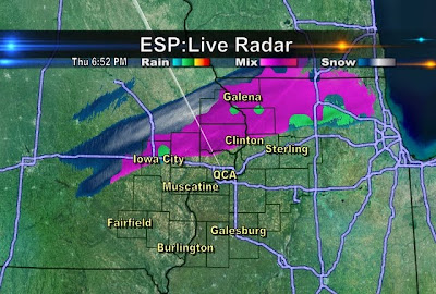
Light Snow Closing in on QCA


Portions of Northern Iowa have seen a light mixture of rain/snow over the last several hours...and that mixture is now closing in on the QCA! With temperatures dropping this evening it's likely to change over to all snow and some spots north of the Quad Cities could pick up a quick dusting to half an inch! In the Quad Cities metro area we could see some snow showers but accumulation is not likely tonight...

5 Year Anniversary

While we do have a chance for a few flurries this evening in the QCA it could be much worse! On December 1st, 2006, we picked up 8.3" of snow! And 6 of the next 7 nights saw temps drop into the single digits! Here's a link to the storm summary from the local office of the NWS!

http://www.crh.noaa.gov/dvn/?n=12%2F1%2F06snowstorm

Wednesday, November 30, 2011

Door #1 and Door #2

OK so maybe it's more like Path #1 and Path #2 but the exact track our weekend storm takes will play a big role in the weather we see Saturday and Sunday! Right now we're leaning toward a track that more resembles #1 than #2...and that means we can expect a rainy Saturday afternoon and evening. After that a mixture of rain and snow is possible late Saturday night and early Sunday with limited, if any, accumulations! The forecast could still change but as of right now it looks like this Low will bring more wet weather than "white" weather!

A Warm Oct. and Nov. Lead to a Chilly Dec.


In the graphs to the left: Light green is the average temp, Light red is the record high, Light blue is the record low, and dark blue is the actual temp. We were above average for the first half of October. After a quick cool down we returned to average temps for the end of the month. November was much more of a roller coaster ride with temperatures. When the high was above average, it was way around 5°-10° above average! Also the coolest days of the month were only a few degrees below the average.

The average high temperature for the month of October is 64°. For October 2011 we averaged high of 67°, which is 3° above the expected value. The average monthly low for 2011 was 1° below the expected value.

The average high temperature for the month of November is 49°. For November 2011 we averaged a high of 53°, which is 4° above the expected value. The average monthly low for 2011 was 3° above the expected value.

Tuesday, November 29, 2011

Festival of Trees Fun


Here are a couple pics from the Festival of Trees Celebrity Waiter Luncheon last week...it's a fun event I look forward to all year long! This year I was lucky enough to arm-wrestle local MMA legend Pat Militech! Lucky for him I did not eat my Wheaties that day...the best news of all though is we raised some good money for a great cause!

Monday, November 28, 2011

Weekend Snow Update

We haven't seen much change in the forecast models for the upcoming weekend...and that means we're still in line for a chance of snow Saturday night and Sunday! To read a little more about what some of these numbers mean read back a couple posts on this blog...

A Cooler Week Ahead


With temperatures the past few months climbing into the 50s and 60s, we have been spoiled in the QCA. That is looking to end in the final week of November as most models are beginning to agree. High temperatures this week will stay at or around average temp, in the upper 30s and lower 40s. The coolest start to this week will be Tuesday (tomorrow) morning with lows close to the 20° mark and a brisk North wind at 10-20 mph. So grab that jacket!