Friday, May 31, 2013

Another One For The Record Book

We just can't break the cycle of rain across eastern Iowa and west-central Illinois.  More rain is on the way to the area today, tonight, and Saturday.

As of Thursday night, we're already up to 7.94" of rain for the month of May in the Quad Cities.  That now ranks as one of the wettest Mays on record.


We're at #8 right now and it would not be out of the question to pick up another inch or two of rain if we get caught under a persistent thunderstorm.  One inch of rain before midnight Friday would push us to #7 and two inches would send us up to #3!!!

This top ten appearance comes just a month after we closed out April as one of the top ten wettest, too.  In April 2013, the Quad Cities recorded 7.21" of rain for a 4th wettest April on record finish.

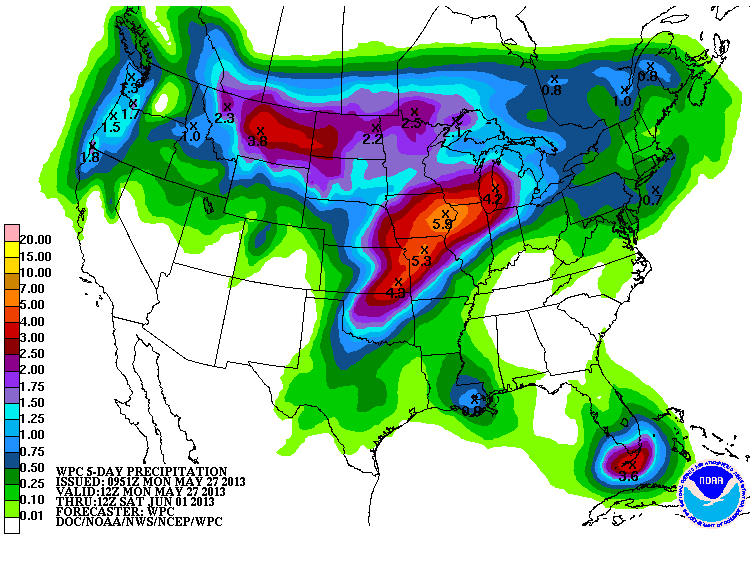
We're not alone with the heavy rain.  Look at how much rain has fallen in the past week.


After more scattered showers Sunday to kick off the month of June, it looks like we'll have a chance to dry out for a couple of days, Sunday and Monday.

Make the most of your weekend!

CBS4 meteorologist Anthony Peoples

Thursday, May 30, 2013

Severe T-Storm Reports May 30

Tornadoes, hail, damaging straight-line winds, heavy rain and plenty of lightning - we saw it all across the Quad Cities area today!  Here are the local storm reports...


And we weren't the only ones dealing with rough weather today.  Look at the storm reports from across the country as of 9pm!  A powerful spring storm provides the chance for more severe storms on Friday!

Severe Weather Possible Later Today & Friday

A "Flash Flood Watch" is in effect for all of eastern Iowa and much of west-central Illinois through Saturday morning.

With plenty of Gulf of Mexico moisture in place, heavy rain is likely this afternoon through Friday evening.  This means any of the showers and thunderstorms that develop have the potential to drop very heavy rain in a short period of time.  Another 1-3" (or more) of rain is not out of the question by Saturday morning.

If the threat of flash flooding wasn't bad enough, we could see severe thunderstorms this afternoon and evening and, again, Friday afternoon.


The yellow-shaded area is where the Storm Prediction Center (SPC) expects a slight chance of severe storms this afternoon and the red shading is a moderate threat.

For our area, while there could be a tornado or large hail, the biggest threat is damaging winds.

And, we'll see another threat tomorrow.  As a matter of fact, I think we'll see a better chance for more widespread strong to severe storms Friday.  Here is the SPC outline for Friday.


As always, CBS4 chief meteorologist Andy McCray will be monitoring the skies for you this afternoon and tonight and I'll be here to cover the overnight hours and early Friday to keep you informed and safe.

Have a great day!

CBS4 Meteorologist Anthony Peoples

Wednesday, May 29, 2013

Quad Cities Rain - May 2013

It's been a wild stretch of wet weather in the Quad Cities over the last 5 days, and the last 2 months!  Remember April was the 4th wettest April on record and May is just about to enter the top 10 as one of the wettest Mays on record!  Here are a few stats from the last few days, last few months...and remember how dry last year was?  We could see more rain in the first 5.5 months this year than ALL OF LAST YEAR!


There's more heavy rain coming up Thursday and Friday and then it looks like a break from the heavy stuff, finally!  We sure could use one...

Tuesday, May 28, 2013

Flash Flooding South of the Quad Cities

Galesburg, IL took it on the chin Tuesday evening...folks there were the hardest hit from the severe t-storms and heavy rain that rolled through parts of the area.  Doppler radar estimates and spotter reports indicate about 3 inches of rain fell in about 90 minutes on Tuesday evening.  This led to major flash flooding throughout the city and throughout a portion of Knox Co. 

As of 11pm here are the active Watches/Warnings for the CBS4 viewing area, all for Flash Flooding.


And here's a pic from Alexis Cory of some of the flash flooding in Galeburg, IL...


Severe Storm Update

After a relatively dry Monday night things could get stormy again this evening. A Tornado Watch has been issued for several counties SW of the Quad Cities. This watch includes Muscatine and Johnson counties in Iowa and goes until 10pm. Thunderstorms will develop further SW of the Quad Cities and move into our area later this evening. We can't rule out a couple tornadoes but hail and strong winds will be even bigger threats once the strong t-storms arrive!

CBS4 will have a complete update on CBS4 News at 5 and 6 and remember you can also see the HD Radar, with all current warnings, right here on cbs4qc.com! (Check out the weather page)


Slight Chance of Severe Storms

Heavy rain fell to the north and the south of the Quad Cities early Tuesday.  While the metro area only picked .09" of rain in a thunderstorm, Dubuque, Iowa, saw more than an inch of rain fall in just a couple of hours before sunrise.

There is plenty of moisture available and any showers and thunderstorms that develop today, tonight, and Wednesday (and, again, Thursday, Friday, and Saturday with the next system) have the potential to drop heavy rain and cause flash flooding.

If that wasn't bad enough on top of the recent 2-6" of rain that fell over the Memorial Day weekend, with the building heat and humidity, strong to severe thunderstorms are possible later Tuesday.

Here is the outline area by the Storm Prediction Center that's under a "slight" risk (yellow shading) between 7 a.m. Tuesday and 7 a.m. Wednesday.


Large hail and damaging winds are the biggest threats with any severe storms that develop in and near the Quad Cities.

CBS4 meteorologist Anthony Peoples

Monday, May 27, 2013

The Waiting Game

With heavy rain in the forecast for tonight it's now a bit of a waiting game for the Quad Cities!  A few evening t-showers were possible but we escaped that threat...later tonight we won't be so lucky!  Showers and t-storms are now forming well West of the Quad Cities and some of this wet weather will reach us after midnight.  Before that happens we could see new development in/around the Quad Cities.  This is possible anytime from 8pm - midnight...

Here's a plot of American model rainfall over the next 7 days, notice the spike early this week!


And another product to look at, from the Weather Prediction Center of the NWS.  This shows 24 hour rain totals from Mon evening through Tues evening.  Notice the heaviest totals just West of the Quad Cities (that would be a good thing fro the QC metro area.)


Most of our area is under a Flash Flood Watch and we will see heavy rain tonight.  It boils down to this - if we pick up another inch or inch and a half we'll see more flash flooding like we saw over the holiday weekend.  If the heaviest totals (4 or 5 inches) end up in the Quad Cities we'll be in big trouble, with major flash flooding and basement troubles all over the Quad Cities!

Too Much Rain

It's been a soggy Memorial Day weekend with several rounds of showers and thunderstorms and more are on the way.

Look at some of these impressive rainfall totals from Saturday through Monday morning.


With that heavy rain and more expected later Monday into Tuesday, we remain under a "Flash Flood Watch" until Tuesday morning. 

And, if that wasn't bad enough, check out the projected rainfall totals from NOAA's Weather Prediction Center from 7 a.m. Monday through 7 a.m. Saturday.


Yes, it's possible that we could several more inches of rain this week. 

CBS4 Meteorologist Anthony Peoples

Saturday, May 25, 2013

Soggy Memorial Day Weekend

It was a dreary day in the Quad Cities on Saturday with showers and even a few thunderstorms throughout the day, and temperatures hovering in the lower 50s!  Sunday looks to be well below average as well with scattered showers and thunderstorms on and off throughout the day, especially in the morning.

Temperatures look to be just a tad warmer on Memorial Day, with highs in the lower 70s.  Unfortunately, there is the chance for scattered showers and storms that day as well.

I decided to look up some weather facts for Memorial Day.
  • Average High: 76.7° -- Average Low: 55.6°
  • Warmest High: 98° on May 30, 1934 -- Coolest High: 52° on May 28, 1984
  • Warmest Low: 74° on May 26, 2006 -- Coolest Low: 36° on May 25, 1992
  • Normal Rainfall Amount: 0.14"-0.15"
Last year we had a high temperature of 89° with 0.61" of rainfall!  This year temperatures will be about 15° cooler (near our average high) but the chance for precipitation is there.  We could see 1-2 inches of rainfall through Memorial Day here in the QCA.  Speaking of rainfall, there has been at least a TRACE of precipitation measured in Moline 77 out of the last 143 Memorial Days-- that's a little over half!


Thanks to all who have and still are serving for our wonderful country!

Thursday, May 23, 2013

Community Wide Drive for Disaster Relief

If you've been thinking of a way to help the victims of the deadly tornado in Oklahoma earlier this week we have just the thing for you!  CBS4 is proud to partner up with the American Red Cross this Friday for a Community Wide Drive for Disaster Relief! 

We'll be collecting monetary donations all day long on Friday at Schwiebert Park in Rock Island and we'd love to see you!  All you have to do is drive up and roll your window down, we'll practically do the rest!  The event runs from 5am to 6:30pm on Friday, May 24th...check our website for more info: cbs4qc.com


Tuesday, May 21, 2013

Nice Tuesday Evening

So we had no CBS4 News at 6pm today - CBS News had a special 90 minutes of CBS Evening News with Scott Pelley.  I had a few extra minutes for dinner so I checked things out at Scwiebert Park in Rock Island!  I've bee nthere many times but each time I go I think about what a great job Rock Island did with this park!  It's great down there and every time I'm there I always see a lot of people having a great time! 

Here's a shot of Davenport this evening, with some nice cumulus clouds!


Monday, May 20, 2013

Stormy Week Rolls On

After a relatively quiet 12 months of severe weather across the country things have taken a deadly turn for the worse over the last week or so!  Starting late last week the atmosphere was primed for several severe weather outbreaks and that nasty trend continues this week. 

Parts of Moore, OK, were leveled today by an EF-4 tornado (EF-4 at least, an official survey report will come out in the days to come.)  This is the same town that was crushed by an EF-5 tornado back in May, 1999.  What makes this even more difficult to stomach - tens of elementary students are among those killed by today's twister...

Follow CBS News for the latest on the awful events of May 20th in Oklahoma...

Here's an early look at some of the storm reports from the SPC today...

Sunday, May 19, 2013

More Than Just the QCA Affected by Severe Storms

The severe weather that affected the Quad Cities area Sunday also left its mark in many other areas across the country.  Here is a look at the storm reports from Sunday.  There were 130 hail reports, 168 wind reports, and 23 reports or tornadoes.
One of those tornado reports came from just north of the Quad Cities, between Thompson and Argo Fay in Illinois.  Fortunately, no injuries were reported in the area and there were only minor reports of damage.

More severe weather is possible on Monday due to this slow moving, pesky upper level low off to our west.

Of course, you can count on us here at CBS4 to keep you updated on any severe weather that does develop.

Meteorologist Kyle Kiel

Friday, May 17, 2013

Slight Risk for Severe T-Storms Sunday

Most of our Friday night looks fine, and Saturday looks good too!  Things change though on Sunday, when we have a slight risk for severe thunderstorms starting late in the afternoon!  Sunday warms up quite a bit, with highs into the middle 80s!  Humidity creeps up a little also, and a cold front will be approaching from the West...while it's still a complicated forecast and things could change over the next 48 hours, areas West of the Quad Cities especially are on track for thunderstorms.  Our biggest threats look to be hail and strong winds!

Thursday, May 16, 2013

A Good Tornado Record To Set

It's been a very quiet year for tornadoes across Iowa and it's record setting!

As of yesterday, the state has gone 356 days without a tornado.  The last touchdown was back on May 24, 2012, near Hawkeye, in Fayette County, which is located in northeastern Iowa near the borders of Wisconsin and Minnesota.


The previous record of 355 days was established between May 5, 1955, and April 26, 1956.

There is a chance that that streak may come to an end late this weekend or early next week.  Here is the latest severe weather threat map from the Storm Prediction Center.


That red shaded area is for Sunday and Sunday night and the purple shading is for Monday and Monday night.  It indicates where there is, at least, a 30% chance of either damaging winds, large hail, or tornadoes.

We'll continue to monitor this situation and keep you updated.

Anthony Peoples
CBS4 meteorologist

Wednesday, May 15, 2013

Quiet Tornado Season... So Far

For those of you that love the sound of thunder or the thrill of a severe thunderstorm, you've had a rather dismal spring here in the Midwest. 

However, that could change later this weekend into early next week.  While we have a daily chances of scattered showers and thunderstorms, along with a sun and cloud mix, there are growing indications that we could see some strong to severe storms later Sunday into Monday.

Here is where the Storm Prediction Center expects the best chances of severe storms this weekend.

The red is for the Saturday and Saturday night time period, the purple is for Sunday and Sunday night, and the green is Monday and Monday night.  Keep in mind that this is still days away and the forecast will be fine tuned between now and the weekend.

This spring has been rather quiet for tornadoes reported to the Storm Prediction Center.  In the first 14 days of May, there have only been 19 reported tornadoes.

In April 2013, there were only 97 with 26 of those reported on April 11th.  March 2013 saw only 24 reported tornadoes.

Strangely enough, January and February 2013 was easily much more active than March, April, and the first part of May.

In January 2013, there were 94 reported tornadoes.  68 of those were on January 29th across the Mid-South and the following day, 15 tornadoes were reported over the southeastern United States.

In February 2013, there were 54 reported tornadoes. 

From a climatological standpoint, we see the fewest tornadoes in the United States in the winter months of December, January, and February.

Have a great rest of the week.

Anthony Peoples
CBS4 meteorologist

Tuesday, May 14, 2013

Record highs - May 14th

We missed our record high by a few degrees today, but there were plenty of records broken through the middle part of the country!  What's even more remarkable...a lot of places that had snow in early May soared into the 90s/100s today!  Sioux City, IA broke the record for May 14th, and for the whole month of May this afternoon!


This is a SMALL sampling of some of the record highs set today!

Monday, May 13, 2013

From Near Record Lows to Near Record Highs!

It won't take long this week to go from near record lows to near record highs!  Seriously, a little less than 36 hours is all it will take!  The record low for Monday morning in the Quad Cities is 31°, set in 1971, and we bottomed out at 32°!  The record high Tuesday afternoon is 93°, set in 2007, and we should top out around 90°!

It's not often you see a temp spread like this in such a short time!

Sunday, May 12, 2013

Frost Advisory

If you helped Mom plant some new flowers outside today you better help her cover them up tonight!  With temps into the middle 30s late tonight there will be some patchy frost across parts of the area.  Most of the CBS4 viewing area, including the Quad Cities, is under a Frost Adviosry tonight! 


This should be the end of the really cold weather this season though!  By Monday afternoon we're near 70° and we should be way up in the 80s Tuesday afternoon! 

Friday, May 10, 2013

How Long has it Been Since our Last Tornado Warning?

Check out these stats!  This is an updated map that shows how long it's been since the last TORNADO WARNING was issued by each office of the NWS!  The last time our office (Quad Cities) issued a Tornado Warning was 368 days ago!  This is more evidence of how little severe weather the U.S. has seen over the last 12 months.  It appears the period from May 2012 - April 2013 will have the lowest number of EF-1 and stronger tornadoes on record for the 12 month stretch!


Kudos to Iowa Environmental Mesonet for this cool graphic!

Thursday, May 9, 2013

Quad Cities Deals

This week it's a really SWEET deal from CBS4!  Have you tried Jujube Frozen Yogurt yet? 

How would you like ice cream with a fraction of the calories? Let Jujube Frozen Yogurt satisfy your craving for delicious, fat-free, low-fat, yogurt? And don’t forget the tasty toppings…from fruit to cereal to candy, you’re sure to find your favorite. Right now, get a $10 gift certificate for just $5.


Here's how it works once you're there!

 3 simple steps will get you your yogurt!

First, you get your cup!

Second, Pick ALL of the delicious flavors you want!

And the third and final step, weigh & pay!

The cost of your yogurt depends on YOU! It is 45 cents an ounce!

Click here to get yours now!

Tuesday, May 7, 2013

How To Calculate How Far Away Lightning Strikes

Eventually we'll get some nasty t-storms this season around the Quad Cities...it's inevitable!  And those storms will pack damaging winds, hail and a lot of heavy rain.  Something else they'll be sure to spread our way - thunder and lightning (not in that order though!) 

A few things to remember - if you can hear thunder you are close enough to the storm to be struck by lightning so you need to head inside.  And why does some thunder sound so muich louder than other claps of thunder?  The most important thing is how far away the lightning struck...the closer the bolt the quicker you hear the sound and generally the louder it is! 

Here's a general rule of thumb from the National Weather Service to figure out how close lightning strikes:

"To estimate the distance between you and a lightning flash, use the "Flash to Bang" method: If you observe lightning, count the number of seconds until you hear thunder. Divide the number of seconds by five to get the distance in miles."

In other words:
If Thunder is heard The Lightning is...
5 seconds after a Flash 1 mile away
10 seconds after a Flash 2 miles away
15 seconds after a Flash 3 miles away
20 seconds after a Flash 4 miles away
25 seconds after a Flash 5 miles away
30 seconds after a Flash 6 miles away
35 seconds after a Flash 7 miles away
40 seconds after a Flash 8 miles away

This info will come in handy for Wednesday's Weather Trivia question on CBS4!  And here's a link to the info from the NWS: Click Here

Finally, Temperatures Are Above Average

While it's still early May, Monday's high of 76° and the low of 49° pushed our temperatures above average for the month.

It's still too early to tell if we'll continue this trend through the end of the month, but we'll definitely be warmer than average for the next few days.


Today, tomorrow, and Thursday's highs in the mid-70s to around 80° and lows in the 50s will add to the above average temperatures for May before we cool down for the weekend.

January 2013 ended up being 2.6° above average and that was followed by three consecutive months with cooler than average temperatures:  February (-0.1°), March (-7.7°), and April (-2.8°).

After this Mother's Day weekend cool down, more warmth will build next week.  The red lines on this forecast map shows warm air pushing back into the Midwest early next week.


Enjoy your week!

Anthony Peoples
CBS4 Meteorologist

Monday, May 6, 2013

I'll Have Another!

After a beautiful Monday afternoon with highs in the 70s all across the area Tuesday looks good too!  The normal high right now is 70° and we'll end up 5-10 degrees above normal on Tuesday afternoon, with more sunshine!  The nice weather won't last all week long though - another cold front brings rain and cooler weather starting Wednesday night!

Monday's Highs - All in the 70s!
 

Saturday, May 4, 2013

Recent Rains Affect the Mississippi Once Again

The the first four days of May (through 4:30PM May 4th), the Quad City International Airport in Moline has picked up 2.12 inches of rain.  While it is not the 3 to 6 inches of rain the area saw a few weeks ago, it is enough to cause minor problems along the Mississippi River.

As of Saturday evening, the river is slightly below flood stage at 14.8 feet.  Flood stage is 15 ft.  The Mighty Miss is expected to slowly rise throughout the work week, reaching flood stage sometime Monday afternoon and going slightly above that by the time Wednesday rolls around.  Posted below is the forecast from the NOAA.  The highest the river is forecast to rise this time around is 15.2 feet, which is minor flooding.


After the rain we saw Saturday, the Quad Cities should stay dry through mid-week, when another system could bring us a few showers and thunderstorms come Wednesday with a better chance on Thursday.  At this point, it does not look like that rain will have a huge affect on area rivers.  Of course, if that changes the CBS4 weather team will let you know!

Friday, May 3, 2013

Impressive Storm Winding Down

Our early May storm is proving to be on for the record books!  Here in the Quad Cities we picked up rain, and lots of it!  It turned out to be a record for most rain ever on May 3rd in Dubuque! 

Here's the record report from the NWS: 

A RECORD RAINFALL OF 1.08 INCHES WAS SET AT DUBUQUE IA TODAY. THIS
BREAKS THE OLD RECORD OF 0.99 SET IN 1935.

And here are some rain totals from around the Quad Cities as of 9pm:

The storm's biggest punch was from snow, and most of the snow fell West of the Quad Cities.  Here's a nice storm summary from the Weather Prediction Center branch of the NWS...Click Here  Some of the snow totals are amazing! 

Have a great weekend!

Crazy May Weather

The weather across Iowa and Illinois definitely has people talking.

Heavy snow fell across the "Hawkeye State" Wednesday, Thursday, and Friday.  This is a snowfall accumulation map through 11:30 p.m. Thursday.  Notice that "bullseye" over north-central Iowa near the Minnesota border.  That's about 11" of snow!

On Thursday, Des Moines, Iowa picked up 3.4" of snow.  Not only was that a record for the date, but it's also a record for the most snow ever in the month of May and the highest single day May snow total.  And, Des Moines has picked up additional snow on Friday to add to that monthly record!

While we escaped the snow across eastern Iowa and northern Illinois by being on the "warm" side of the storm, we're going to experience moderate to heavy rain though Friday night with totals exceeding 2" in some hometowns.  Scattered showers are likely this weekend, too.

Here are some of the rainfall totals from Thursday into Friday morning, as of 9 a.m.


Thursday, May 2, 2013

May 1-2, 2013 snowfall timelapse, Owatonna, MN

Click on the link to see a crazy snow timelapse movie from Minnesota this week!  All kinds of May snow records are falling in Iowa, Minnesota and Wisconsin! 

Wednesday, May 1, 2013

More Rainy Weather

It was nice to start the month of May off with some warm, dry weather in the Quad Cities.  Unfortunately it will be a long time before we have another day like today!  A slow moving, but potent cold front is heading this way.  The front arrives tonight and temps will be much colder on Thursday and Friday. 

That's only part of the problem though - heavy rain is likely late Thursday and Friday.  Most of us will see a couple inches of rain, but this forecast from the NWS Weather Prediction Center shows the potential for up to 4 inches of rain around the Quad Cities over the next 5 days...after all the April showers this would not be a good thing at all!

5 Day Rain Totals
 
2 inches would be 1 thing - 4 inches could be very bad news!