

Sunday, March 31, 2013
Severe Storms on Easter Sunday
Saturday, March 30, 2013
Snow possible on Easter Sunday?

Thursday, March 28, 2013
How Accurate Is The Old Farmer's Almanac?
We're almost three months into the new year and I'm sure some of you might be looking over your "2013 Old Farmer's Almanac" and wondering if the temperature and precipitation forecasts are accurate.
The "Almanac", which has been published since 1792, claims an accuracy rate of 80%. But, is it really. As I was spring cleaning at home, I came across the 2011 edition. I looked through it to see if there was anything I wanted to save before recycling it and I decided to check the forecast and see how correct it was for eastern Iowa and northern Illinois.

When I started checking the "Almanac" forecast to the actual weather for that year, I was very lenient in grading. I didn't even check the detailed forecast for actual dates for those months because there's no way to forecast that far in advance! I just checked the monthly temperature and precipitation forecast.
For temperatures, the "Almanac" was 42% accurate. For instance, it predicted December 2010 temperatures to be three degrees above and the month ended up 5.3° below average in the Quad Cities. Many other months were off the mark. However, in September 2011, it predicted that temperatures would be four degrees below average and that's how it turned out!
As for precipitation, the forecast trends were more accurate. The "Almanac" was 75% accurate!
I always find it interesting to read the "Old Farmer's Almanac" and the "Farmers Almanac" (published since 1818), but if you really want to trust the forecast, you have to watch the CBS4 weather team!
Have a great day!
Meteorologist Anthony Peoples
The "Almanac", which has been published since 1792, claims an accuracy rate of 80%. But, is it really. As I was spring cleaning at home, I came across the 2011 edition. I looked through it to see if there was anything I wanted to save before recycling it and I decided to check the forecast and see how correct it was for eastern Iowa and northern Illinois.

For temperatures, the "Almanac" was 42% accurate. For instance, it predicted December 2010 temperatures to be three degrees above and the month ended up 5.3° below average in the Quad Cities. Many other months were off the mark. However, in September 2011, it predicted that temperatures would be four degrees below average and that's how it turned out!
As for precipitation, the forecast trends were more accurate. The "Almanac" was 75% accurate!
I always find it interesting to read the "Old Farmer's Almanac" and the "Farmers Almanac" (published since 1818), but if you really want to trust the forecast, you have to watch the CBS4 weather team!
Have a great day!
Meteorologist Anthony Peoples
Wednesday, March 27, 2013
Warmer this Weekend, Then More Chilly Weather!
We're long overdue for a warm-up, and we'll finally see one this weekend. Unfortunately for everybody ready for some nice spring weather the mild temps only stick around for a few days...then we're right back down below average!
Check out this chart - it shows ensemble data (many different model runs with slightly different initial conditions) displaying a rise in temps this weekend followed by more cool/chilly weather next week! Think of the white dot representing the average of the different ensemble members, with the green showing the range of of the different forecasts!
Check out this chart - it shows ensemble data (many different model runs with slightly different initial conditions) displaying a rise in temps this weekend followed by more cool/chilly weather next week! Think of the white dot representing the average of the different ensemble members, with the green showing the range of of the different forecasts!
 |
| You Definitely Won't See This on TV! |
Monday, March 25, 2013
More Below Average Temps This Week!
Things will trend in the right direction this week - if you're looking for warmer weather! That being said, we're so far below normal there's a long way to go before we get back to average or above average weather! The normal high right now is 53° and we'll be close to normal by this weekend! By Saturday the normal high is up to 56° and we should be very close to that! Check out our website to see the rest of the 7-day forecast!

Can you believe the last time we had an above average high temp was in the middle of February!?!?!?
Can you believe the last time we had an above average high temp was in the middle of February!?!?!?
Friday, March 22, 2013
East Coast Meteor
Hundreds of reports are coming in tonight about a bright meteor being spotted from New England down to North Carolina...here's a screen grab from a nice website that tracks these kinds of things...

And if you want to check out that site Click Here
And there's video of the meteor also, captured by a security camera...check out my FB page to see the video!
https://www.facebook.com/AndyMcCrayWhbfTv?ref=hl#!/AndyMcCrayWhbfTv

And if you want to check out that site Click Here
And there's video of the meteor also, captured by a security camera...check out my FB page to see the video!
https://www.facebook.com/AndyMcCrayWhbfTv?ref=hl#!/AndyMcCrayWhbfTv
Sunday Snow Forecast
Our weekend storm is coming into focus over the last couple hours...and it looks like the heaviest snow will slide just SOUTH OF THE QUAD CITIES. An area of low pressure will track through the middle part of the country, laying down a swath of heavy snow in portions of Missouri and central Illinois. A Winter Storm Watch is in effect for some local counties from Sunday at midnight through Sunday 7pm.
We should see about 2-3 inches of wet snow in the Quad Cities, while areas from Fairfield and Burlington to Galesburg could see up to 6 or 7 inches of snow!
With this storm, like many winter storms, the path the low takes will be critical to just how much snow we end up with. Check out this ensmeble from the NWS Weather Prediction Center. It shows where different models place the area of low pressure at different times...each little dot marks a different forecast for the center of low pressure!

 |
| Winter Storm Watch |
 |
| Snow Forecast |

Spring Flooding Threat
Precipitation (rain and melted snow) in just the first part of 2013 in the Quad Cities is already running about 2.8" above average.
We've already seen some flooding on area lakes, rivers, and streams across the Mississippi and Illinois Valleys earlier this month, but we could be seeing more this spring.
Here is the Spring Flood Risk forecast from NOAA.
 Unfortunately, it shows a "moderate" risk of flooding across eastern Iowa and western Illinois. For the rest of Illinois, there is a "minor" risk.
Much of this forecast will depend on how much rain and snow falls this spring and how fast the snow melts across Minnesota, Wisconsin, and the Dakotas. There's still roughly 20-39 inches of snow still on the ground to our north.


We've already seen some flooding on area lakes, rivers, and streams across the Mississippi and Illinois Valleys earlier this month, but we could be seeing more this spring.
Here is the Spring Flood Risk forecast from NOAA.

Much of this forecast will depend on how much rain and snow falls this spring and how fast the snow melts across Minnesota, Wisconsin, and the Dakotas. There's still roughly 20-39 inches of snow still on the ground to our north.

And, from this wet precipitation forecast locally for April, May, and June from NOAA, it's not looking good.

Thank you for checking out our blog.
Meteorologist Anthony Peoples
Wednesday, March 20, 2013
March 2012 vs March 2013

This graphic sums it up pretty nicely, last year was incredibly warm and this year just about the polar opposite! Check out the high temp for March 20th - last year it was a record high of 82°, this year it's almost the coldest high we've ever had on a March 20th - a frosty 27°! By the way - all of those highs listed from last year are record high temps!
And in case you haven't heard, there's a chance for snow this weekend!
Tuesday, March 19, 2013
Weekend Snow Storm?
It's Tuesday and you might've already heard about a chance for snow this weekend...and you should know there are some very high snow totals tossed around by some weather models. At this point in time the term "tossed around" fits pretty well. The storm that will be responsible for any snow this weekend is a VERY LONG WAY AWAY right now...in fact, it's in the middle of the Pacific Ocean. Here's a satellite image from this evening...
When these storms are out over the open ocean we don't collect very much weather data, in other words there aren't many surface obs and there's not much upper air data to go by either. This means it's tough to say:
1. Exactly where the storm will track
2. How strong the storm will be when it arrives in the middle US
3. How fast it will be moving
4. If it will be strengthening/weakening when it does arrive
All of these factors (and more) will eventually determine whether the storm lays down a lot of wet snow around the Quad Cities, or now snow at all in the Quad Cities! If you look through enough models you can find date to support either solution...in fact, this week 2 or our more typically reliable models are putting out very different forecasts for late this weekend.
The GFS shows very heavy snow in the Quad Cities late this weekend...while the bottom image (the Euro model) shows hardly any snow at all! While there are some things yet to be determined, one thing you can trust is Anthony Peoples and I will be watching this storm very closely for the next several days, and we'll keep you posted on CBS4 News and cbs4qc.com!
 |
| A Lot of Ground (& Water) to Cover |
1. Exactly where the storm will track
2. How strong the storm will be when it arrives in the middle US
3. How fast it will be moving
4. If it will be strengthening/weakening when it does arrive
All of these factors (and more) will eventually determine whether the storm lays down a lot of wet snow around the Quad Cities, or now snow at all in the Quad Cities! If you look through enough models you can find date to support either solution...in fact, this week 2 or our more typically reliable models are putting out very different forecasts for late this weekend.
 |
| GFS snow totals |
 |
| Euro snow totals |
Last Day of Winter
Spring officially arrives in the Quad Cities at 6:02 a.m. CDT Wednesday.
Unfortunately, this doesn't mean the winter chill will be ending anytime soon. On Monday, we picked up 0.5" of snow in the Quad Cities pushing our winter total to 30.1", which is a little above average.

While we'll see plenty of sunshine through the rest of this week, a storm system late in the weekend could bring us the more snow or a wintry mix.
If we pick up measurable snow this upcoming Sunday (March 24th), how would that stack up with the last measurable snows of the past five winters?
WINTER'S LAST MEASURABLE SNOW
2011-2012 0.9" March 4, 2012
2010-2011 0.3" February 26, 2011
2009-2010 2.9" March 20, 2010
2008-2009 1.1" April 5, 2009
2007-2008 1.5" March 27, 2008
The latest measurable snow on record in the Quad Cities fell on May 3, 1935. Yes, we've had measurable snow in May!
Meteorologist Anthony Peoples
Monday, March 18, 2013
Severe Weather Monday
While we deal with the unseasonably cold weather in the Quad Cities other parts of the country are dealing with stormy weather! From Tennessee through the Gulf Coast states there have been more than 250 reports of severe weather today, including a couple tornadoes. The biggest problems by far though have been damaging winds and hail! Here are today's storm reports as of 9pm from the Storm Prediction Center...
And we've had just under 1 inch of snow in the Quad Cities, but parts of the Dakotas just got done with a March blizzard! They saw heavy snow, strong winds and now they're dealing with temps and wind chills that are below zero! Here's a NWS Aberdeen, SD graphic from today!
 |
| Severe Weather Reports |
 |
| Blizzard! |
And we've had just under 1 inch of snow in the Quad Cities, but parts of the Dakotas just got done with a March blizzard! They saw heavy snow, strong winds and now they're dealing with temps and wind chills that are below zero! Here's a NWS Aberdeen, SD graphic from today!
Friday, March 15, 2013
More Cold Weather Coming Up!
It's been plenty cold in the Quad Cities recently...our high temps have been consistently below normal since the middle of February (remember when it started snowing?!) And all signs point to more cold weather for the next 2 weeks! We might not warm up significantly until we get into April! Making matters worse for a lot of folks - the memory of 7 record highs in a row last year between March 14-20th!
Here are a few products from the Climate Prediction Center of the NWS...the first showing the likelihood of below normal temps in the 6-10 day range and the 2nd showing colder than normal temps from days 8 -14!
Here are a few products from the Climate Prediction Center of the NWS...the first showing the likelihood of below normal temps in the 6-10 day range and the 2nd showing colder than normal temps from days 8 -14!
 |
| March 21-25 |
 |
| March 23-29 |
Drought Continues Heading Into April
It may be hard to believe that, even with the heavy rains and snow melt last weekend, that drought conditions still persist across eastern Iowa and northern Illinois.

The latest Drought Monitor report (3/12/2013) shows that eastern Iowa is still suffering from abnormally dry conditions and that parts of northwestern Illinois are still in a "moderate drought".
However, this is much better than just six months ago. Check out this map from September 11, 2012.
 The orange represents a "Severe Drought" and the red signifies an "Extreme Drought".
The drought situation has been helped by the above average rain and snow since December. Between December 1, 2012, and March 14, 2013, the Quad Cities (the official totals from the Quad City International Airport) have picked up 10.29" of precipitation. In that time period, 6.51" is average.
Since the ground is still pretty much frozen, most of the excess rain and melted snow is running off into area rivers, which is bringing up the river levels and causing some flooding. As you recall, the drought caused exceptionally low river levels late last year.
What we really need is for some warmer weather to thaw the ground so the spring rains can soak in and replenish the water levels.
Here's NOAA's forecast for temperatures and precipitation for the March 22-28, 2013, period.


The bad news is that temperatures are expected to remain below average, so the thawing of the ground will be a slower process.
Thank you for checking out the blog and have a great weekend.
Meteorologist Anthony Peoples

The latest Drought Monitor report (3/12/2013) shows that eastern Iowa is still suffering from abnormally dry conditions and that parts of northwestern Illinois are still in a "moderate drought".
However, this is much better than just six months ago. Check out this map from September 11, 2012.

The drought situation has been helped by the above average rain and snow since December. Between December 1, 2012, and March 14, 2013, the Quad Cities (the official totals from the Quad City International Airport) have picked up 10.29" of precipitation. In that time period, 6.51" is average.
Since the ground is still pretty much frozen, most of the excess rain and melted snow is running off into area rivers, which is bringing up the river levels and causing some flooding. As you recall, the drought caused exceptionally low river levels late last year.
What we really need is for some warmer weather to thaw the ground so the spring rains can soak in and replenish the water levels.
Here's NOAA's forecast for temperatures and precipitation for the March 22-28, 2013, period.


The bad news is that temperatures are expected to remain below average, so the thawing of the ground will be a slower process.
Thank you for checking out the blog and have a great weekend.
Meteorologist Anthony Peoples
Thursday, March 14, 2013
St. Patrick's Day Forecast
Remember last year's St. Patrick's Day parade? It was warm, with record highs in the 70s and 80s all across the area! If you look closely in the video you'll see a bunch of people in shorts and short sleeves! No such luck this year, temps will actually be below normal this weekend.
The parade starts at 11:30 in Illinois (Rock Island) and ends in Iowa (Davenport.) Grab the green jacket if you're checking it out...temps will be in the 30s!

Wednesday, March 13, 2013
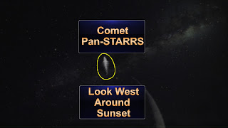
Comet Pan-STARRS
Clear skies this evening will provide a great star-gazing (comet-gazing, actually) opportunity! For a little while now Comet Pan-STARRS has been visible in the southern hemisphere. This week though it's now visible for folks in the northern hemisphere, including right here in the Quad Cities! Look West between 7:15 and 7:45 this evening and look close to the crescent moon. You should be able to see a faint outline of the comet! Binoculars will help but it should be visible to the naked eye!
Here are a few links with more info!
AccuWeather story
weather.com story
Let us know if you have any luck spotting the comet!
Here are a few links with more info!
AccuWeather story
weather.com story
Let us know if you have any luck spotting the comet!
Flooding Following Last Weekend's Rain
A few area streams and rivers are still flowing out of their banks after the heavy rains and melting snow this past weekend.
While the Maquoketa River has gone down some, the Wapsi River in DeWitt, Iowa, the Cedar River in Conesville, Iowa, and the Rock River in Joslin, Illinois, are still in flood.
These pictures are from Georgia Pond of East Moline, Illinois, who lives on Barstow Road near Lundeen's Landing.


The good news is that while we may see a light wintry mix Thursday morning and, again, Friday night, rain and snow amounts will be on the light side.
Have a great Wednesday!
Meteorologist Anthony Peoples
Tuesday, March 12, 2013
What a Difference a Year Makes
Check this graphic out...
This is what it was like 1 year ago! We saw plenty of sunshine, flowers were coming up, the grass was greening up, and you were more likely to have your AC on instead of the furnace! It's just not in the cards for us this March, even though I expect a quick warm-up Friday there's more cool weather coming up later this month! Hopefully you enjoyed last March, most people I've spoken with this year are ready for some March 2012 weather...I guess we'll have to wait til April!
 |
| LAST MARCH, not a forecast! |
This is what it was like 1 year ago! We saw plenty of sunshine, flowers were coming up, the grass was greening up, and you were more likely to have your AC on instead of the furnace! It's just not in the cards for us this March, even though I expect a quick warm-up Friday there's more cool weather coming up later this month! Hopefully you enjoyed last March, most people I've spoken with this year are ready for some March 2012 weather...I guess we'll have to wait til April!
Monday, March 11, 2013
Looking Ahead to St. Patrick's Day Weekend
So St. Patrick's Day is this Sunday and it should be a little bit warmer here in the Quad Cities by then. Only a little bit though! Last year we had a high of 82° on St Patrick's Day, this year we'll top out in the lower to mid 40s Saturday and Sunday. Here's a look ahead to help you decide if you want to go with the green t-shirt or more likely the green sweatshirt! Have fun checking out the parade and everything else green this weekend!

Friday, March 8, 2013
Weekend Forecast
In one word - rainy! After some great sunshine Friday things are clouding up again Friday night. By the time most of us wake up on Saturday morning it will be raining! Showers will stick around off and on through the weekend. By Sunday night temps will be getting just cold enough some wet snow could mix in with the rain, and just for fun - one of our evening forecast models is suggesting the possibility of accumulating wet snow Sunday evening! I'm not ready to officially forecast that just yet, but I won't be surprised if we see some wet snow by the end of the weekend.
Warmer weather greets us for next weekend as we celebrate St. Patrick's Day! Here's the 10 day, have a good weekend!

And remember, you can also check out the forecast on our website! http://www.whbf.com/weather
Warmer weather greets us for next weekend as we celebrate St. Patrick's Day! Here's the 10 day, have a good weekend!
And remember, you can also check out the forecast on our website! http://www.whbf.com/weather
Thursday, March 7, 2013
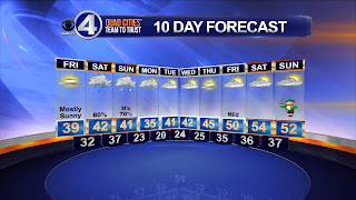
10 Day Forecast
Look down toward the end of this 10-day forecast - notice St. Patrick's Day isn't too far away, and notice the warmer weather coming up next weekend! This weekend in the meantime looks wet, and cooler than normal. The normal high right now is into the middle 40s.
Tuesday, March 5, 2013
Snow Totals
After some heavy snow this morning things have been winding down over the last few hours. As the storm pulls off to the East there's definitely some shoveling to do around the area. Galena registered almost 9 inches of snow, and most places around the Quad Cities picked up anywhere from 4-6 inches! We'll see some sunshine Wednesday and Thursday and then the melting really kicks in this weekend. There's rain in the forecast and highs should get back into the 40s this weekend!
Here are some snow totals from Illinois and Iowa...


And a link to a storm summary page from the NWS. Click Here
Here are some snow totals from Illinois and Iowa...


And a link to a storm summary page from the NWS. Click Here
Monday, March 4, 2013
Quad Cities Snow Forecast
9:45 pm update: - Snow forecasts update for Ten at 10 - Snow forecasts will be slightly lower for the Quad Cities...check out Ten at 10 in a couple minutes for an update!
In the Quad Cities we're looking at 5-8" of snow later tonight and Tuesday! That's enough snow to warrant a Winter Storm Warning for the Quad Cities metro area. If you've been following the forecast over the last few days you might have noticed a slight uptick in the snow amounts for the Quad Cities...the reason for the adjustment today is most of the models are coming into agreement now on the path of the storm. An area of low pressure will be tracking just South of the QC and that places us closer to the heavy snow band for this storm! Here are a few different model solutions, and after you look at these you'll notice a few things:
1. Sharp cutoff from NE to SW across the CBS4 viewing area.
2. A slight shift in either direction could greatly affect the Quad Cities snow totals.
3. Decent agreement on how much snow will fall in the Quad Cities, a consensus forecast is anywhere from 4-9 inches on most model solutions.
 |
| CBS4 Forecast |
1. Sharp cutoff from NE to SW across the CBS4 viewing area.
2. A slight shift in either direction could greatly affect the Quad Cities snow totals.
3. Decent agreement on how much snow will fall in the Quad Cities, a consensus forecast is anywhere from 4-9 inches on most model solutions.
 |
| GFS |
 |
| NAM |
 |
| Canadian model |
Winter Storm Warning
The QC metro area has been upgraded to a WINTER STORM WARNING all day long on Tuesday! Heavy snow and winds will pack quite the punch as the storm blasts just South of the Quad Cities. In the metro area I'm calling for 5-8" of snow by Tuesday night, on top of all the snow that's already out there from last week!

Winter Weather Advisory
After making it through all of December and January, and most of February relatively unscathed by any big snowstorms mother nature is getting a little revenge on the Quad Cities over the last week or so. And there's more snow on the way for later tonight and Tuesday! The Quad Cities metro area is under a Winter Weather Adv for Monday evening through Tuesday evening, with 4-6 inches of snow possible! Areas North of the QC will see even more snow, so a WINTER STORM WARNING is in effect for these areas! Locations under the warning could see about 8 inches of snow by Tuesday night, get those shovels ready again!


Subscribe to:
Posts (Atom)