Thursday, June 30, 2011

Hail Heading for Chicago


There's a huge t-storm over Lake Michigan right now and it's dropping to the South/SW. Portions of Chicago could see hail larger than 2" in diameter within the next hour!

Wednesday, June 29, 2011

Excessive Heat Watch


The QCA is under an EXCESSIVE HEAT WATCH for Friday afternoon and evening. This is likely to be a dangerously hot day with heat index values well over 100°! Click on this link for hot weather facts, safety tips and more from the National Weather Service!


http://www.weather.gov/om/heat/index.shtml

Tuesday, June 28, 2011

What a Day!


Absolutely perfect! Wednesday looks great too, check us out on CBS4 News at 5pm for the forecast...and of course team coverage on the President's visit to the QC!

Sunday, June 26, 2011

Severe T-Storm Watch Until 4 AM


A Severe Thunderstorm Watch is in effect until 4 am for the all the counties shaded in yellow until 4 am. A line of storms is moving into our area. They have a history of producing large hail and strong, damaging winds. They are moving to the East at 60 mph.

Recent Severe Weather Events


There hasn't been as many tornado reports recently, which is great news considering all the devastation they've caused this year. However, wind and hails reports seem to be a little more common these days. That's because thunderstorms are developing in clusters or in a long line (like the one shown below that's moving through Western Iowa tonight).


These types of systems are known as Mesoscale Convective Systems or MCSs. These systems produce strong winds and large hail rather than tornadoes. That's because when thunderstorms form in a line it's more difficult for winds to rotate in the storms that would allow a tornado to form. Mesoscale Convective Systems are more likely to produce strong, straight-line winds and they are still pretty dangerous!

Saturday, June 25, 2011

8-14 Day Climate Outlook for the QCA


Several big events are coming up in the QCA including the Mississippi Blues Festival, 4th of July, the Firecracker Run, and of course the John Deere Classic. So will the weather cooperate for you to get out and enjoy these events? According to the Climate Prediction Center, temperatures will run below average from the 3rd of July to the 9th. However, there is some good news! Precipitation will be near average during this time. It's still too far out to know exactly what we can expect, but hopefully the weather cooperates so that you can get out of the house and have some summer fun!

Thursday, June 23, 2011

A Quiet Day Across the Country


We've seen more than enough severe weather reports so far this season, so today's map of storm reports is welcome news! There have been some wind reports, especially throughout the Eastern quarter of the country, but overall things are starting to quiet down! The next chance for storms in the QC arrives Saturday night!

No Record Today...


No new records for us today, but that's not a bad thing! If we were going to set a new record it would have been for the Coolest High Temperature ever on June 23rd! I know it's a bit of a goofy record to keep track of, but it is something meteorologists consider! The record cool high for today is 67°, from back in 1969...and while most of today we have seen temperatures in the 60s for a short while earlier we did hit 71°, so the record is off the table! It looks like we could warm up significantly next week! We'll keep you posted!

And by the way, here are today's hourly temperatures starting at 9am and lasting through 3pm, notice the 71 is nowhere to be found. That means we quickly snuck up to 71 and then quickly faded away!

63
64
67
65
68
66
63

Tuesday, June 21, 2011

Severe T-Storm Watch East of the QCA


A Severe Thunderstorm Watch is in effect for Bureau, Lee, Knox, Stark, and Henry counties until 1 am. The primary threats with these storms will be heavy rain, wind, and hail. Stay with CBS4 News for the latest developments!

Monday, June 20, 2011

Severe Thunderstorm Watch Until 6am


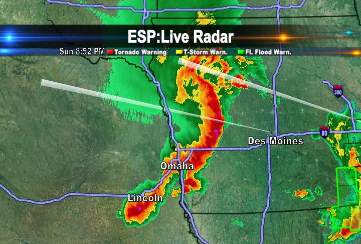
The National Weather Service has issued a severe thunderstorm watch until 6am for all the counties shaded in blue. The storms are moving to the Northeast rather slowly so they will produce heavy rain over a short period of time. Watch out for flash flooding and podding on the roadways. Large hail and strong winds are also possible with these storms.

Because of the heavy rain potential the National Weather Service has also issued a Flash Flood Watch. Details from the NWS are below:

THE NATIONAL WEATHER SERVICE IN QUAD CITIES HAS ISSUED A

* FLASH FLOOD WATCH FOR PORTIONS OF ILLINOIS...SOUTHEAST IOWA
AND NORTHEAST MISSOURI...INCLUDING THE FOLLOWING AREAS...IN
ILLINOIS...HANCOCK...HENDERSON...MCDONOUGH...MERCER AND
WARREN. IN SOUTHEAST IOWA...DES MOINES...HENRY IA...
JEFFERSON...KEOKUK...LEE...LOUISA...VAN BUREN AND WASHINGTON.
IN NORTHEAST MISSOURI...CLARK AND SCOTLAND.

* THROUGH MONDAY AFTERNOON

* THUNDERSTORMS WITH HEAVY RAINFALL OF 1 TO LOCALLY AS MUCH AS 4
INCHES IS LIKELY OVERNIGHT AND MONDAY MORNING. HEAVY RAIN
FALLING ON ALREADY SATURATED SOILS COULD LEAD TO RAPID RUNOFF
AND FLASH FLOODING.

* SIGNIFICANT TO POTENTIALLY MAJOR FLASH FLOODING IS A RISK FOR
SOME LOCATIONS IN FAR SOUTHEAST IOWA...WEST CENTRAL ILLINOIS
AND NORTHEAST MISSOURI.

Sunday, June 19, 2011

Chances for Severe Weather Coming Up...


A warm front will push northward on Monday and provide us with the chance for showers and thunderstorms. As the front moves into the QCA, some of the storms could be strong to severe so the Storm Prediction Center has place our area under a slight risk for severe weather on Monday. We remain under a slight risk for severe weather on Tuesday when a cold front moves into the region from the west. The best chance for storms on Tuesday will be in the late afternoon and early evening.

Saturday, June 18, 2011

Lightning Safety Awareness Week...


It's lightning safety awareness week from June 19th through June 25th. On average 55people are killed by lightning each year. If you hear thunder it's best to get inside right away because lightning could strike at any moment shortly after you hear thunder. Be sure to stay away from water, trees, and metal objects. For more information on lightning safety check out the National Weather Service's webpage at: www.lightningsafety.noaa.gov

Friday, June 17, 2011

Chances for Storms


A warm front is pushing through the area and the front is not going to move very much over the next few days. Unfortunately the threat of showers and storms will continue for much of the weekend. However, the weekend is not going to be a complete wash out as storms will be scattered and isolated across the area. So while some areas may experience wet weather others may remain dry!

Monday, June 13, 2011

Showers SW of QC...For Now


Rain continues tonight in places like Bloomfield and Fort Madison, Iowa (Well Southwest of the Quad Cities.) Our chance for rain is late tonight, after midnight in fact, as showers and storms are now developing well off to the West...

Sunday, June 12, 2011

Heavy Rainfall in our Future?

There are several chances for showers and thunderstorms over the next few days. Late Monday evening, there is the possibility that some storms that develop could be strong to severe and produce periods of very heavy rain. In fact, forecasters are suggesting that between Monday and Tuesday night some towns around the QCA could pick up over an inch of rain.


Additionally, over the next 6-10 days, the Climate Predicion Center is projecting that our region will see above normal precipitation. This is not good news especially after last week's storms that moved through the area and caused flash flooding in several areas.


Saturday, June 11, 2011

A Stop in the Tropics...

Hurricane season is upon us and so far all is quiet in the Atlantic Ocean. However, there is one storm in the Pacific Ocean right now. As of Saturday evening, Tropical Storm Adrian is moving to the west at 12 mph with winds of 50 mph. In order for a storm to be considered a hurricane it must have winds of 74mph or greater. Tropical Storm Adrian is not forecasted to reach hurricane strenght, but weaken into a tropical depression by Monday. Below is a table of the Saffir-Simpson Hurricane Scale.


Thursday, June 9, 2011

WOW! Heat Burst!


A few places have seen major "Heat Bursts" in the Midwest lately. This is not a reference to the warm days we had earlier in the week, rather a specific meteorological happening that sends the temperature soaring, in the middle of the night! Last night after midnight the temp went from the lower 80s to over 100° in Wichita, KS...and in a matter of minutes! Check out this link from the NWS in Wichita for a cool read!

http://www.crh.noaa.gov/news/display_cmsstory.php?wfo=ict&storyid=69444&source=0

More Rain Tonight


With more showers and t-storms West of the QC right now rain is likely again tonight. Some of the rain could be heavy so there's a Flash Flood Watch in effect for most of the area. The rain that falls tonight could quickly overcome already saturated soils from this morning's heavy rain!


Monday, June 6, 2011

Why is it so Hot?


The hot temperatures are coming into the QCA because there is a high pressure system to our southeast and a low pressure system to our northwest. This setup allows for strong winds to come from the south and those winds are bringing up warm, moist air from the Gulf of Mexico.

The Heat Is On...


A heat advisory is in effect for all of the counties shaded in yellow until Wednesday evening. Temperatures will climb into the 90s, but it will feel like it is 100° or better over the next few days. On Monday, all of us made it into the low to mid 90s. Our record high for Tuesday is 99°. I am forecasting a high of 96° on Tuesday so it looks like we might just miss on breaking any records!

Sunday, June 5, 2011

Weather Related Deaths


Over the next three days temperatures are going to be sitting in the low to mid 90s in the QCA. So it is important to check on the elderly, pets, and kids. Make sure you're wearing light colored clothing and that you drink plenty of water to stay cool and hydrated. Most think that hurricanes and tornadoes kill the most people each year. However, heat was the number one cause of weather related deaths in the U.S. last year and heat is one death behind hurricanes over a 10 year period. So be sure to stay cool and be sure to check on your elderly neighbors!

Saturday, June 4, 2011

Big Storms East of the QCA


Saturday was pretty uneventful for the QCA. Just a few light passing showers and some thunderstorms south of the QCA. However, the weather was pretty active in parts of Indiana and in Ohio for Saturday afternoon and Saturday evening. Check out the infrared satellite picture (1st image) from 830 pm Saturday evening. You can see massive clouds all over Indiana and stretching into Ohio. You can tell that these are very tall thunderstorm clouds because the darker, brighter colors indicate areas of high cloud tops. And the radar picture (2nd image) shows the nasty storms associated with those clouds.


One of the storms was responsible for a tornado in Northwest Indiana late Saturday afternoon near a campground in Vanmeeter Park. There were no reports of injuries or damage with this tornado. There were also several reports of strong wind in these areas as well (shown below).

Severe Thunderstorm Watch


A Severe Thunderstorm Watch is in effect until 12 AM for Knox, Stark, Des Moines, Henderson, Henry, Jefferson, and Warren Counties. I'll have a full update on your weather at 6 on CBS4 News.

Wednesday, June 1, 2011

Tornado Video

Have you seen the tornado video from today in Springfield, MA? It was captured by the local CBS station's Skycam as it crosses over a river there! I have it on my Andy McCray WHBF Facebook page, if you want to see it look me up!

Nice Start to June!


What a nice day across the QCA! We're seeing plenty of sunshine with temps near 80! The chance for showers/storms returns late tonight...